 MineArchive
Coal Measures
| Also known as | Pennine Coal Measures Group, Coal Measures Group, Westphalian |
|---|---|
| Category | Prospecting & Exploration |
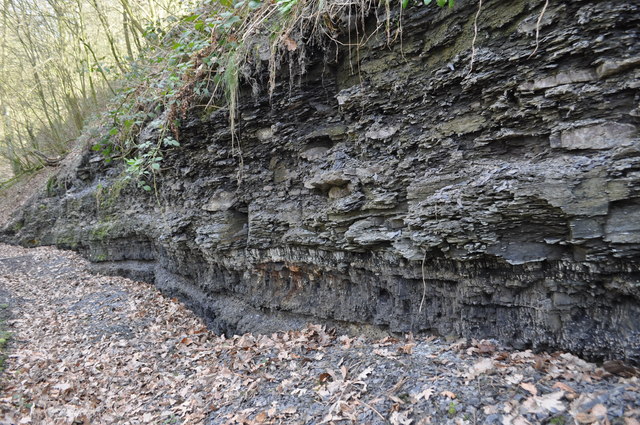
The coal-bearing strata of the Upper Carboniferous, Westphalian in age, in which almost every British coalfield lies: repeated cycles of mudstone, siltstone and sandstone, each capped by a seatearth and a seam of coal.
Historical usage
Coal Measures was for a century the name of a span of time as much as of a rock: everything Westphalian and Stephanian, lying above the Millstone Grit and below the Permian. The British Geological Survey now uses it for the rock itself, the Pennine Coal Measures Group of the Pennine Basin, divided into Lower, Middle and Upper Coal Measures on the scheme of 1957 and redefined as a lithostratigraphical group in 2000; South Wales has its own Coal Measures Group, and the barren red beds that follow in the Midlands are the Warwickshire Group. The seams the archive's collieries worked, Barnsley and Silkstone, Hutton and Low Main, Arley and Trencherbone, are beds within it, and the shales between them carried the clay ironstone that fed the ironworks and the seatearths that made fireclay and ganister.
How it worked
The Coal Measures were laid down on a vast delta plain in the Pennine Basin, then on the equator, where rivers from the north and east brought sand and mud onto a waterlogged plain that sank as fast as it filled. Each cycle, commonly up to fifteen metres thick, runs upward from mudstone through siltstone to sandstone, then a seatearth full of Stigmaria rootlets, the soil of the forest that grew on it, and the coal that forest became; at least forty such cycles are known in County Durham. Coal is a minor part of the thickness: a seam up to about two metres thick stands for peat perhaps ten times as deep. Thin marine bands, laid down when the sea flooded the plain, run across whole coalfields and are the means of correlating one pit's seams with another's, and the three main ones divide the Westphalian into its Langsettian, Duckmantian and Bolsovian stages. The best coals lie in the middle, from the later Langsettian to the mid Duckmantian. The measures were deposited as one sheet; Variscan folding and the erosion that followed left them only in the downwarps, which is why Britain has separate coalfields, exposed where the measures crop out and concealed where Permian and Triassic rocks cover them.
Why it was used
A collier's whole world is a column of Coal Measures. Knowing the order of the cycles, and which marine band lies above which seam, is how a sinking is planned, how a seam is followed across a fault, and how a borehole in one district is read against a shaft in the next.
Risks & limitations
The measures are not uniform. A sandstone body may stand where a seam should be, seams split and thin across a coalfield, and coal rank varies with burial and the heat of the rocks beneath: the highest-rank coals of Durham lie in the west, above the granite of the North Pennine batholith. Where the measures lie close beneath the Permian unconformity they are reddened and oxidised to a depth of a hundred metres and more. The same mudstones that hold the ironstone make a weak roof.
Regional variation
The Pennine Coal Measures Group covers the Midlands and the North from the Warwickshire coalfield to Northumberland and Cumbria; South Wales, Scotland and the smaller southern coalfields carry their own group names, and 'measures' is used loosely in every coalfield for the beds between the seams.
Related terminology
Anthracite, Blackband Ironstone, Borehole, Cannel Coal, Carboniferous Limestone, Coal, Fireclay, Ganister, Ironstone
Mines associated with this term
5 examples chosen from 310 linked records — the term page is not an index.
- Addiewell Oil Works — West Lothian (well documented example)
Named in this record’s geology: “…shale bands sit within an otherwise ordinary Carboniferous coal-measures sequence, and were worked much as coal was — by shaft and mine — but…” - Auchenharvie Colliery — North Ayrshire (well documented example)
Named in this record’s geology: “…is cut by a whin dyke — an intrusion of igneous rock through the coal measures — known as the Capon Craig Gaw. It formed the boundary between…” - Bullcroft Colliery — South Yorkshire (well documented example)
Named twice in this record, first in the history: “…in the shafts, and this succeeded; sinking resumed and reached the coal measures in December 1911 at 657 yards. The colliery was sunk to the Barnsley…” - Chisnall Hall Colliery — Lancashire (well documented example)
Named in this record’s geology: “The colliery worked the coal measures of the Lancashire coalfield on Coppull Moor, at its northern end…” - Cortonwood Colliery — South Yorkshire (well documented example)
Named in this record’s geology: “Cortonwood worked the classic Coal Measures sequence of the South Yorkshire coalfield: a stack of workable seams…”
Sources
- (primary) BGS Lexicon of Named Rock Units: Pennine Coal Measures Group — British Geological Survey
- (primary) Pennine Coal Measures Group, Carboniferous, Northern England — BGS Earthwise
- (secondary) Coal measures — Wikipedia
Record created: 16 October 2026 · Last researched: 16 October 2026