 MineArchive
Rookhope (Boltsburn Mine)
| Location | Rookhope, County Durham — 54.7797, -2.0994 (approximate) |
|---|---|
| Commodities | Lead, Fluorspar |
| Type | Metal |
| Worked | early 19th century–1931 |
| Maximum depth | Unknown. |
| Operators | Weardale Lead Company (?–1931) |
Overview
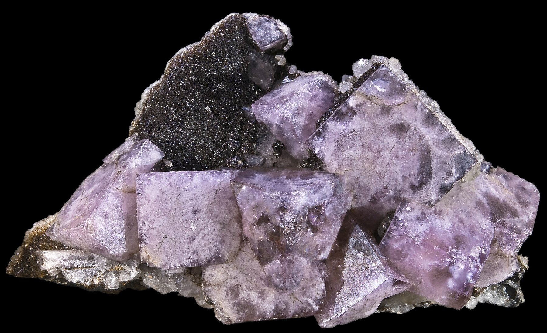
Boltsburn Mine, on the edge of Rookhope village in Weardale, was worked from the early 19th century by the Weardale Lead Company. Its vein was always fairly poor in lead ore, but a chance 1892 discovery of rich mineralised ground beside it made Boltsburn briefly one of the most productive mines in England — and a source of exceptionally fine fluorite, some of it good enough to be sold to German optical manufacturers such as Zeiss.
History
Boltsburn was developed in the early 19th century to work a vein at the junction of the Boltsburn and Red veins, west of Rookhope village, its dressing floors inherited from the Beaumont Company. The vein itself was never especially rich in galena, but in 1892 miners broke into mineralised 'flats' — near-horizontal, replacement-style ore bodies — adjacent to the vein, which proved extraordinarily productive and made Boltsburn, for a time, one of the richest mines in England. The Weardale Lead Company's own figures give Boltsburn East 100,000 tons of lead concentrates and 7,299 tons of fluorspar concentrate before it closed in 1931; the company employed about four hundred men across its mines in 1913.
Rookhope was awkward to get out of. The Weardale Iron Company closed its railway between Rookhope and Parkhead Depot, leaving the village and its mines with nothing but road transport, and the Weardale Lead Company answered that in 1923 by opening a three-mile aerial ropeway from Boltsburn to the railway at Eastgate. A narrow 1 ft 10 in gauge line had run from Boltsburn Mill Mine to the Lintzgarth smelter from 1913 until the ropeway replaced it.
The mine closed in 1931, but not quite finally: a Boltsburn West working produced about 5,000 tons, opening in 1930 and closing with the rest in 1931, then reopening from 1935 until 1941. Mary's, on the Red Vein, had its own runs from 1884 to about 1891 and from 1918 to about 1930.
Geology
The mine worked the north-east trending Boltsburn Vein and the 'flats' found alongside it in 1892 — near-horizontal replacement bodies in the Great Limestone, where the limestone has been replaced from the vein outwards. The vein itself was comparatively poor in galena but the ground was unusually rich in fluorspar, and the flats were world famous for the magnificent fluorite cubes found in their cavities, some of optical quality. Boltsburn sits in the fluorite-rich central zone of the Northern Pennine Orefield, whose mineral zonation is read as the record of fluids cooling as they moved outwards from 'emanative centres' above high points on the concealed Weardale Granite — the granite that the Rookhope Borehole, drilled beside this very shaft in 1960-61, was the first to prove.
Geological setting: Iron Replacement Deposits (well documented example), Veins and Lodes (well documented example)
Workings
Underground workings eventually extended around 3.5 km from the main shaft. The dressing floors, inherited from the Beaumont Company, were extensively rebuilt in 1903-4 to take five jigs, a Record table, round buddles, Brunton belts and hand dolly tubs, and rearranged again in 1948-9 to receive the jigs from Sipton Mill; a flotation plant was installed in 1955 and a Wemco heavy-media separator in 1960. Ore left by the three-mile aerial ropeway to Eastgate from 1923.
Closure
The mine closed in 1931, undone by labour costs and the expense of hauling ore from workings by then far from the main shaft, though ore reserves remained. Boltsburn West worked again from 1935 to 1941. The mill outlasted the mine entirely: Boltsburn Mill remained the Weardale Lead Company's central dressing plant into the 1970s, taking ore by lorry from the Redburn and Burtree Pasture fluorspar mines, and some 50,000 tonnes of 'Black Dump' jig tailings from the old Boltsburn workings were reprocessed for fluorspar in those years.
What remains
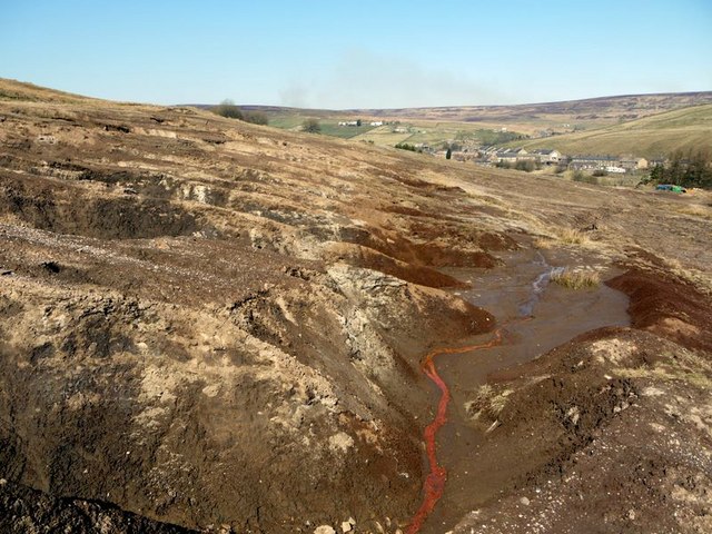
The mine is closed and the site reclaimed. Its main shaft stood on the south bank of Rookhope Burn, opposite the village school, and the British Geological Survey's excursion guide records that apart from the shaft collar and remnants of the waterwheel mountings little remains there today; other mines that worked near the village until recent years have had their sites landscaped. The tailings ground below, the Boltsburn Washings, has been bulldozed and landscaped but the crushed lead and fluorspar waste is toxic and little grows on it. The site is not open for access.
The shaft collar and remnants of the waterwheel mountings, and the landscaped tailings of the Boltsburn Washings below the village. Several of the mine's buildings were put to other uses rather than cleared: the Weardale Lead Company's Rookhope offices were converted from the old Boltsburn compressor and fan houses, and the Boltsburn manager's house was converted for office accommodation in 1975.
Redevelopment
None of the mine. Beside the shaft, though, is the Rookhope Borehole of 1960-61: its core was drilled to 806 m and the bulk of it is kept in an old mine building at Burnside Cottages, immediately west of the village.
Related mines
- Burtree Pasture Mine — Both Weardale Lead Company mines; ore from the 1970s Burtree Pasture reopening was taken to the company's Boltsburn mill at Rookhope.
- Coalcleugh — Both were Weardale Lead Company mines in the North Pennine orefield.
- Greenlaws Mine — Both were Weardale Lead Company mines in the North Pennine orefield.
- Groverake Mine — Both were Weardale Lead Company mines in Rookhope, a few kilometres apart on the same fluorspar-rich ground; the British Geological Survey's excursion guide treats them as consecutive stops.
- Killhope Lead Mine — Both were Weardale Lead Company mines in the same Durham dales.
- Lintzgarth Mine — Both worked in Rookhope under the Weardale Lead Company, and the ore of both was smelted at the company's mill at Lintzgarth until it closed in 1919. Boltsburn, a mile up the valley, was the last major lead mine in the dale and closed in 1931, the year after Lintzgarth's development was suspended.
- Wolfcleugh Mine — Both were Weardale Lead Company mines in the North Pennine orefield.
Nearby mines
- Redburn Mine — 0.6 miles (1.0 km) W
- Lintzgarth Mine — 1.0 miles (1.5 km) W
- Stotsfield Burn Mine — 1.2 miles (2.0 km) S
- Wolfcleugh Mine — 1.8 miles (2.8 km) W
- Brandon Walls Mine — 1.8 miles (2.9 km) SW
Straight-line distance, within 9 miles (15 km). Show on the map.
What's uncertain
Points where sources disagree or the record could not be settled; both accounts are kept. All open questions in the archive.
- The record's original source says the finest fluorite was sold to German microscope manufacturers such as Zeiss; the British Geological Survey's excursion guide says exceptionally clear crystals were exported to Austria for the manufacture of specialised lenses. (disputed) 3
Recorded claims
Individual factual claims, each attached to the source(s) that support it below. Where sources disagree, both are kept.
- A chance 1892 discovery of mineralised 'flats' adjacent to the main vein made Boltsburn briefly one of the richest mines in England. 1,2
- Boltsburn's fluorite was of sufficiently high optical quality that some was sold to German microscope manufacturers, including Zeiss. 2
- A three-mile aerial ropeway, built in 1923, carried ore from Boltsburn to the railway at Eastgate. 1
- The mine closed in 1931 due to labour problems and the rising cost of hauling ore from a working face by then around 3.5 km from the main shaft. 2
- Boltsburn worked the north-east trending Boltsburn Vein and associated 'flats' in the Great Limestone, and was world famous for the magnificent fluorite cubes found in cavities in the flats. 3
- The record's original source says the finest fluorite was sold to German microscope manufacturers such as Zeiss; the British Geological Survey's excursion guide says exceptionally clear crystals were exported to Austria for the manufacture of specialised lenses. (disputed) 3
- The Rookhope Borehole was drilled close to the Boltsburn shaft in 1960-61 and proved the pre-Carboniferous Weardale Granite at a depth of 390.5 m, believed to be one of its shallowest points beneath the orefield; the granite was continuously cored to the bottom of the hole at 806 m, and most of the core is stored in an old mine building at Burnside Cottages west of the village. 3
- Apart from the shaft collar and remnants of the waterwheel mountings, little remains at the mine today. 3
- The Weardale Lead Company's own figures give Boltsburn East 100,000 tons of lead concentrates and 7,299 tons of fluorspar concentrate to its closure in 1931, and Boltsburn West about 5,000 tons, opened 1930 and closed 1931, reopened 1935 and closed 1941. 4
- The Weardale Iron Company closed its railway between Rookhope and Parkhead Depot, isolating the village and its mines except by road; the Weardale Lead Company answered by opening a three-mile aerial ropeway between Boltsburn and Eastgate station in 1923. 4
- Boltsburn Mill remained the company's central dressing plant long after the mine closed, taking ore by lorry from the Redburn and Burtree Pasture mines, and about 50,000 tonnes of 'Black Dump' jig tailings from the old Boltsburn workings were reprocessed for fluorspar. 4
- The dressing floors, inherited from the Beaumont Company, were rebuilt in 1903-4 with five jigs, a Record table, round buddles, Brunton belts and hand dolly tubs, rearranged in 1948-9 to take the jigs from Sipton Mill, and given a flotation plant in 1955 and a Wemco heavy-media separator in 1960. 4
Photographs & further reading
The Survey's field guide, whose Rookhope stop covers the Boltsburn vein and flats, the fluorite, what survives at the shaft, and the Rookhope Borehole that proved the Weardale Granite beside it.
View sourceThe Northern Mine Research Society's account of the company, with a table of output by mine, the history of the Boltsburn dressing floors and mill, and the railways and ropeways that served Rookhope.
View sourceSources
- (secondary) Boltsburn Mine, Rookhope, Stanhope, County Durham, England, UK — Mindat.org
- (secondary) Fluorite Mines in the North Pennines - Rookhope — fluor-spar.com
- (primary) Northern Pennine Orefield: Weardale and Nenthead — an excursion — Brian Young, British Geological Survey, in Northumbrian Rocks and Landscape (Yorkshire Geological Society)
- (secondary) BRITISH MINING No.5: Weardale — Northern Mine Research Society
Record created: 20 August 2026 · Last researched: 9 September 2026