 MineArchive
Coalcleugh
| Location | West Allen, near Alston, Northumberland — 54.8016, -2.3116 (approximate) |
|---|---|
| Commodities | Lead, Fluorspar, Zinc |
| Type | Metal |
| Worked | 17th century–1878 |
| Maximum depth | Unknown. |
| Operators | Blackett-Beaumont family (1729–1878), Weardale Lead Company (1878–1899), Vieille Montagne Zinc Company (1899–1921), Allendale Metalliferous Mining Company (1950–?) |
Overview
Coalcleugh, high in the West Allen valley, was one of the oldest and most important lead mines of the Blackett and Beaumont family's vast Weardale and Allendale mining empire, worked continuously under one dynasty or its successors for close to two centuries.
History
The Blackett family, Tyneside coal owners who diversified into lead, began leasing land in the West Allen from the Bishop of Durham in the 1670s-80s and built up Coalcleugh into one of the principal mines of their growing lead empire; through marriage, the Blackett mining interests passed to the Beaumont family around 1830. The earliest workings followed the Low Coalcleugh Vein from shallow shafts, and a prospecting level, Coalcleugh Level, was later driven to intersect the deeper High Coalcleugh Vein some 2,500 feet from its portal. From around 1760 the Barneycraig Horse Level was driven over a mile into the hillside to reach the separate Barneycraig Vein, which came into full production between 1808 and 1823. Several other veins were worked across the Coalcleugh and Barneycraig ground, and among them a number of flats.
The numbers are those of a major mine. The Beaumont Company worked the two mines from 1729 until 1878 and raised 187,924 tons of lead concentrates in that time, with 311 tons of zinc concentrates between 1874 and 1880 as the trade turned. Falling lead prices in the 1870s forced the closure of the Beaumont family's Weardale and Allendale mines in 1878, and their leases passed to the Weardale Lead Company.
In 1899 the ground was taken over by the Vieille Montagne Zinc Company, the Belgian firm that had bought the Alston Moor leases in 1896 and at one point produced 60 per cent of the United Kingdom's zinc. Between 1899 and 1920 Coalcleugh and Barneycraig gave it 6,687 tons of lead concentrates and 52,566 tons of zinc concentrates - nearly eight times as much zinc as lead, from ground the lead miners had left - with silver running at about 8 ounces to the ton of lead. The company's ore was not smelted here but sorted, crushed and cleaned at Rampgill Mill in Nenthead and shipped to Belgium.
There was one more commodity in the same rock. Around 1950 Coalcleugh was reopened for fluorspar, and the Allendale Metalliferous Mining Company was formed both to work it and to explore 9,000 acres of moorland besides. Lead, then zinc, then spar: three industries out of one hillside, each one using what the last had thrown away.
Geology
The mine worked lead- and zinc-bearing veins in the Carboniferous rocks of the Alston Block, part of the northern Pennine orefield also worked at nearby Nenthead, Allenheads and Killhope. Two veins carry the name: the Low Coalcleugh Vein, taken first from shallow shafts, and the High Coalcleugh Vein, reached by driving. The Barneycraig Horse Level begins beneath the Great Limestone, which is the bed the district's richest ground lies in, and the level's flats were found in the Great Limestone belt on its western side. Fluorspar occurs in the same veins and became the last commodity worked here; the zinc, as sphalerite, sat alongside the galena all along and was waste to the lead miners.
Geological setting: Hydrothermal Deposits (well documented example), Veins and Lodes (well documented example)
Workings
Coalcleugh Level was driven to intersect the High Coalcleugh Vein some 2,500 feet from its portal, while the Barneycraig Horse Level, begun around 1760, ran for over a mile. That level starts under the Great Limestone, runs straight for more than 1,110 metres and then branches west to the Low Coalcleugh Vein by the Flank Level, carrying on another 880 metres to the Whitewood Vein on the east and the Barneycraig Vein on the west, which connects through to Rampgill Mine. An internal level, the Galloway Level, was driven in the shale above the Great Limestone and followed both veins to near the county boundary. The first workings were from three surface shafts, the Low, Middle and High Whimseys. All of Coalcleugh's lead ore was smelted at the Beaumont family's Allenheads Mill at Dirtpot; the Vieille Montagne company's ore went instead to Rampgill Mill at Nenthead.
Closure
The Beaumont Company's Weardale and Allendale mines, including Coalcleugh, closed in 1878 amid collapsing lead prices. The Vieille Montagne Zinc Company reworked the ground for zinc from 1899, its recorded output running to 1920, and around 1950 the Allendale Metalliferous Mining Company reopened the mine again for fluorspar. The Barneycraig Level is blocked today and no longer reaches the Barneycraig Vein, though it runs in for a considerable distance; a serious attempt to dig through near the Flank Level junction was defeated by air too low in oxygen and too high in carbon dioxide.
What remains
Earthwork remains of the shallow shaft workings on the Low Coalcleugh Vein survive as a scheduled monument, Coalcleugh lead rake (list entry 1015833), alongside dressing areas and spoil heaps thought to represent the earliest phase of mining here. Underground, the Barneycraig Level is blocked and the air beyond the Flank Level junction is foul.
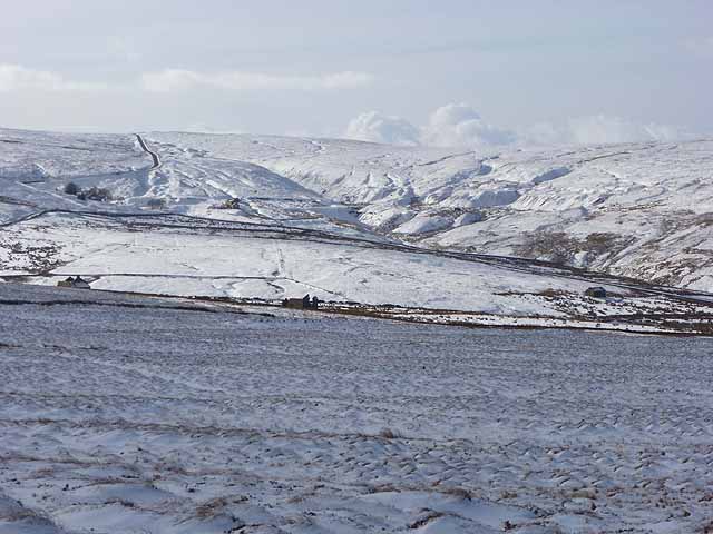
The scheduled Coalcleugh lead rake, with its shaft earthworks, dressing areas and spoil heaps, and the line of the mile-long Barneycraig Horse Level running north towards Carrshield. The head of the West Allen valley carries the spoil of three centuries' working.
Related mines
- Carshield Mine — Two mines of one sett, worked together by the Beaumont Company from 1729 to 1878 and by Vieille Montagne from 1899, and physically joined: the Barneycraig Horse Level, driven from the Carrshield end about 1760, branches west by the Flank Level to the Low Coalcleugh Vein. The 1952 trade-journal survey gives their output as one figure.
- Rampgill Mine — Both were worked by the same operator, the Vieille Montagne Zinc Company.
- Rookhope (Boltsburn Mine) — Both were Weardale Lead Company mines in the North Pennine orefield.
- Swinhope Mine — Neighbouring Beaumont lead mines at the head of the Allen valleys, later both reworked for zinc by Vieille Montagne.
Nearby mines
- Carshield Mine — 0.9 miles (1.5 km) N
- Rampgill Mine — 1.1 miles (1.8 km) SW, Cumbria
- Scraithole Mine — 1.1 miles (1.8 km) N
- Dowgang Mine — 1.3 miles (2.1 km) SW, Cumbria
- Longcleugh Mine — 1.3 miles (2.1 km) SW, Cumbria
Straight-line distance, within 9 miles (15 km). Show on the map.
Recorded claims
Individual factual claims, each attached to the source(s) that support it below. Where sources disagree, both are kept.
- The Beaumont Company worked Coalcleugh and its associated mines from 1729 to 1878, raising 187,924 tons of lead concentrate, besides 311 tons of zinc concentrate between 1874 and 1880. 1
- The Barneycraig Horse Level, begun around 1760, was driven for over a mile to reach the Barneycraig Vein, which came into full production between 1808 and 1823. 1
- Coalcleugh's workings included the Shieldridge Bridge Level alongside the Barneycraig and Coalcleugh Levels already on record; the mine was reopened in the early 20th century for fluorspar under a new concern, the Allendale Metalliferous Mining Company, formed to explore some 9,000 acres of the surrounding moorland. 1
- Coalcleugh had its own on-site mine steward, based at the mine and paid around £60 a year in the 1760s-90s, responsible for developing and operating the workings, employing miners and setting bargain rates, overseeing ore washing and quality, and keeping accounts submitted to the chief steward at Allenheads; William Crawhall, son of a previous Allenheads steward, held the post from 1802 to 1812. 2
- The Vieille Montagne Zinc Company took the Coalcleugh and Barneycraig mines over in 1899 and between then and 1920 produced 6,687 tons of lead concentrates and 52,566 tons of zinc concentrates, with a silver yield averaging 8 ounces per ton of lead. 3
- The Beaumont Company worked Coalcleugh and Barneycraig from 1729 to 1878, raising 187,924 tons of lead concentrates, and 311 tons of zinc concentrates between 1874 and 1880. 3
- Coalcleugh was reopened for fluorspar around 1950, the Allendale Metalliferous Mining Company being formed both for that purpose and to explore 9,000 acres of moorland. 3,4
- The Barneycraig Horse Level starts beneath the Great Limestone and runs straight for over 1,110 metres before branching west towards the Low Coalcleugh Vein by the Flank Level. The main level carries on a further 880 metres, reaching the Whitewood Vein on the east side - the continuation of the Rampgill Vein - and the Barneycraig Vein on the west, which connects with Rampgill Mine. Eastward the Barneycraig Vein connects with the Swinhope Low Level, where it is called Williams Vein. An internal level, the Galloway Level, was driven in the shale above the Great Limestone and followed both the Barneycraig and Whitewood veins to near the county boundary. 5
- Barneycraig's first workings were from three surface shafts, the Low, Middle and High Whimseys, which reached the Barneycraig Vein before the horse level was driven; short surface levels at Mowbray's and Whetstone Mea tested higher horizons without finding anything of importance, and Whetstone Mea was worked for coal. 5
- The earthworks of the shallow shaft workings on the Low Coalcleugh Vein are protected as a scheduled monument, Coalcleugh lead rake, West Allen, list entry 1015833. 4
- The Durham Mining Museum places Coalcleugh at NY 80070 45240, in the head of the West Allen valley at about 514 metres above sea level, with Barney Crag a mile to the north. 4,6
- The mine's record trail includes an award by John Smeaton settling the boundary between Rampgill and Coalcleugh, transcribed in 2011 from the Wallace papers - the same engineer who designed the Nent Force Level on the Cumberland side of the watershed. 4
- The Barneycraig Level is blocked, with no link now to the Barneycraig Vein, though it continues inward for a considerable distance; a substantial attempt at digging near the Flank Level junction was defeated by very bad air, low in oxygen and high in carbon dioxide. 5
Photographs & further reading
The society's account of the Barneycraig Horse Level, its branches to the Low Coalcleugh Vein and Rampgill, the internal Galloway Level, and the level's blocked state today.
View sourceThe museum's site entry, giving the grid reference and listing the lead mines and smelting mills within five miles.
View sourceA reproduction of two 1952 trade-journal articles surveying the North Pennine lead field mine by mine, with production tonnages for Coalcleugh and Barneycraig under both the Beaumont and Vieille Montagne companies.
View sourceSources
- (secondary) Coalcleugh — Wikipedia
- (secondary) Business structure of the Blackett and Beaumonts lead businesses — Dukesfield Smelters and Carriers Project
- (secondary) Lateral Science: A Couple of North Pennines Lead Mine Articles from Mine & Quarry Engineering — Lateral Science
- (secondary) Coalcleugh — Buddlepit Mine Database — Buddlepit Mine Database
- (observational) Barneycraig Level — Mine Explorer Society — Mine Explorer Society
- (primary) Coalcleugh (Lead Ore) — Durham Mining Museum — Durham Mining Museum
- (primary) Coalcleugh Mine Plan (BGS Mine Plans Catalogue) — British Geological Survey
- (secondary) Vieille Montagne History — Alston Moor Historical Society
Record created: 22 August 2026 · Last researched: 28 September 2026