 MineArchive
Scraithole Mine
| Also known as | Scraith Hole, Scrathole Mine, Scathole Mine |
|---|---|
| Location | Carrshield, West Allendale, Northumberland — 54.8177, -2.3084 (approximate) |
| Commodities | Lead, Witherite, Zinc |
| Type | Metal |
| Worked | By the 19th century–1981 |
| Maximum depth | Three levels driven into the valley side rather than a shaft: the Top, Middle and Low Levels, the Low Level lying at about 401 m above sea level. |
| Operators | Vieille Montagne Zinc Company (?–1940), Beaumont Company (?–1896) |
Overview
The second of the two mines of the scheduled Carrshield complex in the West Allen, worked for lead through the nineteenth century by the Beaumont Company and reopened twice in the twentieth, the last attempt closing in 1981 when separating sphalerite from witherite proved uneconomic.
History
Scraithole stands on the west bank of the River West Allen at Carrshield, part of a mining landscape that represents over three centuries of work on one site. The earliest known activity there was a level opened in the 1760s which continued in use throughout the nineteenth century, and whose arched entrance is still visible; Scraithole is the second of the complex's two mines, worked in the nineteenth century by the Beaumont Company, whose interests ran across the North Pennine orefield. The mine consists of three levels — Top, Middle and Low — driven into the valley side, and its later owner was the Vieille Montagne Zinc Company, recorded there in 1940, the same Belgian firm that took over the Nenthead mines and turned the district from lead to zinc.
The mine was reopened in the 1950s and worked again in the 1970s by a Mr E. Richardson, who put up a small gravity dressing plant at the adit. The ore was a mixture of sphalerite, the zinc sulphide, and witherite, the barium carbonate for which the West Allen and Allendale mines were unusually well known; separating the two by chemical means proved uneconomic and the operation shut down in 1981, by which time the mineral rights lay with Allendale Settled Estates Ltd. The workings are among the two whose drainage still carries metals into the River West Allen, and the complex as a whole is a scheduled monument.
Geology
The mine worked the lead and zinc veins of the North Pennine orefield in the West Allen, where the ore carries sphalerite alongside witherite — a barium carbonate for which the Allendale mines are unusually noted, and which is uncommon enough in quantity elsewhere to have shaped the mine's last working. The 1970s venture failed on the chemistry: sphalerite and witherite could not be separated at a price that paid.
Geological setting: Hydrothermal Deposits (historical documentary reference), Veins and Lodes (well documented example)
Workings
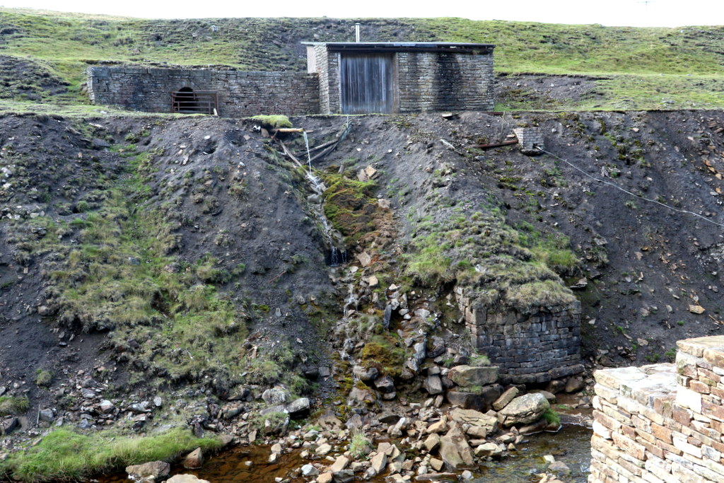
Three levels driven horizontally into the west side of the West Allen valley — Scraithole Top, Middle and Low Levels — rather than a shaft mine. The Low Level adit stands on the west bank of the river beside a small building; the adit portal in the complex is of roughly squared rubble with a round-arched tunnel and is listed. A small gravity dressing plant was erected at the adit for the 1970s working. Around the complex are at least two hushes, a set of bouse teams, a washing floor whose extension was carried on stone revetment walls along the river, the remains of a railway line and tracks giving access to the waste heaps.
Closure
The 1970s reopening under Mr E. Richardson closed in 1981, when the chemical separation of sphalerite from witherite proved economically unviable. The mineral rights were held by Allendale Settled Estates Ltd in 1980-81.
What remains
Standing remains rather than a working mine. The adit and the small building beside it survive on the west bank of the West Allen, and the complex is a scheduled monument. Water draining from Scraithole and from Barney Craig is one of the two sources carrying metals into the River West Allen, and the Mining Remediation Authority treats the two mines together for that reason.
The Low Level adit and the small building next to it; the complex's arched eighteenth-century mine entrance; the two-storey lodging shop, the largest in the North Pennines, with a series of culverts inside and around it, some of which may have drained the mines; at least two hushes; a set of bouse teams and a washing floor; stone revetment walls along the river that once carried an extension of the washing floor; and the remains of a railway line and access tracks to the waste heaps.
Redevelopment
None. The site is a scheduled monument, and the surviving mine shop has been brought back into use as a camping barn.
Related mines
- Carshield Mine — The two mines of the same scheduled complex at Carrshield, sharing its lodging shop, washing floor and hushes; Scraithole is the second of the two and outlasted the other by a century.
Nearby mines
- Carshield Mine — 0.3 km S
- Coalcleugh — 1.8 km S
- Swinhope Mine — 2.3 km E
- Brownley Hill Mine — 3.2 km SW, Cumbria
- St Peter's Mine — 3.2 km NE
Straight-line distance, within 15 km. Show on the map.
Recorded claims
Individual factual claims, each attached to the source(s) that support it below. Where sources disagree, both are kept.
- Scraithole is the second of the two mines of the Carrshield complex, worked in the nineteenth century by the Beaumont Company and reopened in the 1950s. 1
- The earliest known mining at Carrshield was a level opened in the 1760s which continued in use throughout the nineteenth century, and whose entrance arches are still visible. 1
- The mine consists of three levels, the Top, Middle and Low, the published grid reference NY 8028 4703 being that of the Low Level at about 401 m. 2
- The mine was owned initially by the Beaumonts and later by the Vieille Montagne Zinc Company, recorded there in 1940; the mineral rights lay with Allendale Settled Estates Ltd in 1980-81. 2
- The mine was reopened in the 1970s by Mr E. Richardson, who installed a small gravity dressing plant; the separation of sphalerite and witherite by chemical means proved economically unviable, and the operation closed in 1981. 3,2
- The complex includes a two-storey lodging shop, the largest in the North Pennines, with a series of culverts inside and around it some of which may have drained the mines, at least two hushes, a set of bouse teams and a washing floor. 1
- The River West Allen runs through the centre of the complex, revetted with stone walls which once supported an extension of the washing floor; the complex also holds the remains of a railway line and tracks giving access to the waste heaps. 1
- A small building on the west bank of the River West Allen stands next to the adit of Scraithole Mine, photographed there in 2023. 4
- Water draining from Scraithole and from Barney Craig is treated by the Mining Remediation Authority as the two sources whose discharge carries metals into the River West Allen. 5
- The British Geological Survey's mine plan catalogue holds a plan of Scraithole Mine. 6
- The Carrshield lead mines and ore works, including Scraithole, are a scheduled monument, the remains representing over three centuries of mining on one site. 1
Photographs & further reading
The database entry for the mine, giving its three levels, its grid reference, its owners and the failure of the 1970s dressing plant, with eleven published references.
View sourceNewcastle University's page for the scheduled complex, quoting the Northumberland Historic Environment Record's description of the two mines, the lodging shop, the hushes and the washing floor.
View sourceThe authority's project page for the two West Allen mines whose drainage carries metals into the river, treating Scraithole alongside Barney Craig.
View sourceSources
- (primary) Carrshield Lead Mines (West Allen), quoting the Northumberland Historic Environment Record entry N7089 for the scheduled monument — Co-Curate, Newcastle University
- (observational) Scraith Hole, Carrshield — Buddlepit Mine Database
- (secondary) Carrshield mine shop history — Carrshield Camping Barn
- (observational) Scraithole Mine, Carrshield (Geograph 7292549) — Geograph Britain and Ireland
- (primary) Barney Craig — Water and Abandoned Metal Mines Programme — Mining Remediation Authority
- (primary) Scraithole Mine plan — British Geological Survey
Record created: 28 September 2026 · Last researched: 28 September 2026