 MineArchive
Brownley Hill Mine
| Location | Nenthead, Alston Moor, Cumbria — 54.7990, -2.3460 (approximate) |
|---|---|
| Commodities | Lead, Silver, Zinc |
| Type | Metal |
| Worked | worked from the early 1700s–1966 |
| Operators | Vieille Montagne Zinc Company (1914–1936), London Lead Company |
Overview
Brownley Hill, one of the extensive network of mines beneath Alston Moor, was worked first for lead and silver from the early 1700s, then, once high-grade lead ore ran short, for zinc — its underground workings still passable today all the way through to the neighbouring Nentsberry Haggs mine.
History
Brownley Hill Mine was first worked for lead, with silver also recovered, from the early 1700s, initially via surface shafts sunk on the Brownley Hill Vein; the mine passed through various ownerships over the following two centuries, including a period under the London Lead Company. As high-grade lead ore became scarce, the Vieille Montagne Zinc Company took over the lease in 1914 and shifted the mine's focus to zinc ore, working it under that name until 1936. The mine was last worked in 1966. Brownley Hill is also a locality of real mineralogical significance: the rare mineral alstonite was first discovered here in the 1830s, and the mine has since produced notable specimens of galena, fluorite, millerite, sphalerite and rarer supergene minerals.
Geology
The mine worked the Brownley Hill Vein, part of the northern Pennine orefield's hydrothermal, non-magmatic mineralised system, yielding lead and silver in its earlier working and zinc ore in its later phase under Vieille Montagne.
Geological setting: Hydrothermal Deposits (well documented example), Veins and Lodes (well documented example)
Workings
The mine was developed from two main levels, the Bloomsberry Horse Level (also known as Brownley Hill Low Level) and Brownley Hill High Level; many of its workings cross the county boundary into Northumberland and remain connected underground to the neighbouring Nentsberry Haggs mine.
Closure
The mine was last worked in 1966, after more than two and a half centuries of intermittent working under a succession of owners.
What remains
A 2022 underground trip report describes the workings as wet throughout, with rusting pipework and deteriorating wooden supports and ladders; the connection through to the neighbouring Nentsberry Haggs Mine remains passable, exiting via a portal close to a property in Northumberland.
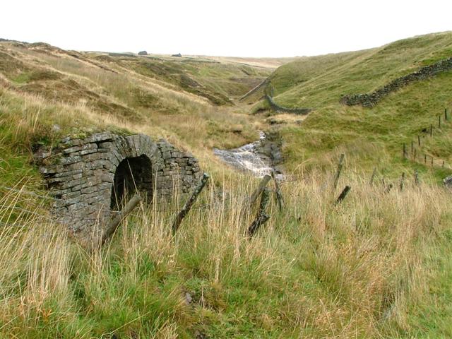
The entrance to the High Level, in Gudham Gill, survives, along with the Low Level entrance further down the gill toward the River Nent.
Related mines
- Nentsberry Haggs Mine — The two mines' underground workings remain connected and passable to each other, crossing the Cumberland/Northumberland county boundary.
Nearby mines
- Nenthead Mines — 0.7 miles (1.1 km) S
- Nentsberry Haggs Mine — 0.8 miles (1.2 km) W
- Dowgang Mine — 0.8 miles (1.3 km) SE
- Longcleugh Mine — 0.9 miles (1.4 km) SE
- Smallcleugh Mine — 0.9 miles (1.4 km) S
Straight-line distance, within 9 miles (15 km). Show on the map.
Underground workings are wet, unstable in places, and extend several kilometres to a connection with Nentsberry Haggs Mine — a serious, committing underground trip, not a casual visit.
Recorded claims
Individual factual claims, each attached to the source(s) that support it below. Where sources disagree, both are kept.
- The rare mineral alstonite was first discovered at Brownley Hill in the 1830s; the mine has also produced notable specimens of galena, fluorite, millerite and sphalerite. 1
- The Vieille Montagne Zinc Company took over the lease in 1914, shifting the mine's focus to zinc ore, and worked it under that name until 1936; the mine was last worked in 1966. 2,1
- Wikimedia Commons holds a dedicated collection of specimen photographs from Brownley Hill Mine, including several alstonite examples (paired with baryte and with witherite) alongside witherite and galena specimens, reflecting the mine's status as a locality of real mineralogical interest. 3
- A 2022 underground trip report shows Brownley Hill's workings as wet throughout, with rusting pipework and deteriorating wooden supports and ladders; the through-connection to the neighbouring Nentsberry Haggs Mine, noted in earlier accounts as blocked by a collapse, remains passable, exiting via a portal close to a property just over the county boundary in Northumberland. 4
Sources
- (secondary) Brownley Hill Mine (Bloomsberry Horse Level), Nenthead, Alston Moor — Mindat
- (secondary) Brownley Hill Mine — Northern Mine Research Society
- (secondary) Category:Brownley Hill Mine — Wikimedia Commons
- (observational) Brownley Hill & Nentsberry Hagg's Mine (through trip) — Cumbria — 2022 — 28DaysLater Urban Exploring Forums
- (primary) Brownley Hill Mine mine plan — British Geological Survey / Geological Survey of Great Britain
Record created: 24 August 2026 · Last researched: 28 August 2026