 MineArchive
Nentsberry Haggs Mine
| Also known as | Haggs Mine |
|---|---|
| Location | Nentsberry, Alston Moor, Cumbria — 54.7995, -2.3650 (approximate) |
| Commodities | Lead, Witherite, Zinc |
| Type | Metal |
| Worked | 19th century–1938 |
| Maximum depth | Wellhope Shaft, sunk 1925, met the horse level at 416 feet |
| Operators | Alston Moor Mining Company (1821–1893), Nentsbury Mining Company (1894–1913), Alston Lead and Blende Mines (1901–1902), Lugdale Chemical Company (1909–1911), Vieille Montagne Zinc Company (1913–1938) |
Overview
A Nent Force Level-connected lead, zinc and witherite mine on Alston Moor, one of the last mines in the district still working after the First World War and, under Vieille Montagne, still receiving ore from new workings as late as the Second World War.
History
Nentsberry Haggs worked numerous veins for lead, zinc and the barium mineral witherite, its portal gated on the north side of the Nenthead-Alston road just west of Nentsberry Bridge. The mine sits directly on the course of the Nent Force Level, the drainage canal begun by John Smeaton in 1776: some three miles from its Alston entrance, the level meets Nentsberry Haggs Shaft via a dramatic 160-foot step before continuing in more normal proportions onward to Brewery Shaft at Nenthead. Many of the veins worked from the Haggs level in fact lie over the county boundary in Northumberland, reachable via Wellhope Shaft.
By 1921, in the difficult years after the First World War, Nentsberry Haggs was one of only a handful of mines still active in the district, alongside a brief resumption at Brownley Hill. Ore dressing was moved from the larger Rampgill Mill to a smaller facility at Nentsberry itself, for convenience to the Haggs mine entrance. When Wellhope Shaft came into production in 1929, its ore too was brought out underground via the Nentsberry Haggs entrance to this smaller dressing mill. The operation was by this period controlled by the Belgian firm Vieille Montagne, with management passing later to Anglo-Austral Mines and then Rampgill Mill Limited. Mining continued in a reduced form into the Second World War: between 1942 and 1945 a flotation plant processed tailings from Nentsberry together with a small output from the neighbouring Rotherhope mine. Tailings are the fine waste left by earlier dressing, and froth flotation is a wet chemical method that lifts the remaining ore particles out of that waste on bubbles — so the plant was not working fresh ground at all, but reworking what the nineteenth-century dressing floors had thrown away.
Geology
Numerous veins on Alston Moor worked for lead, zinc and the barium mineral witherite, cutting the Carboniferous sequence of the Alston Block. The productive ground lies in and below the Great Limestone, and the memoir takes the workings on High Raise Vein here as its typical Alston Moor section of the strata above it: the White Hazle sandstone, shale, a ten-inch coal, the High Coal Sill, shale, a four-inch coal, the Low Coal Sill and eighteen feet of shale. The mine also sits on Carr's Vein, the most important fault of the Nenthead belt, which throws 216 feet north-east where the level crosses it. Barium is what makes the deposit distinctive: witherite occurs with the sphalerite in quantities that defeated the dressing plant, and Alston Moor's witherites are among the finest recorded anywhere.
Workings
Numerous lead, zinc and witherite veins reached at first through the Nentsberry Haggs Horse Level, and from 1925 through Wellhope Shaft, sunk to meet that level at 416 feet, which served veins across the county boundary in Northumberland. Oreshoots averaged six to seven feet wide, with individual widths of twenty and twelve feet. The mine also sits on the course of the Nent Force Level, meeting Nentsberry Haggs Shaft via an unusual vertical step - given as 160 feet on one account and 150 on another - in the level.
Closure
Six companies held the mine between 1821 and 1913, the longest of them the Alston Moor Mining Co. for seventy-two years. Vieille Montagne took over in 1913-14 and kept it a useful lead producer until 1938, which makes it the last substantial lead mine of the district. What followed was not mining: between 1942 and 1945 a flotation plant reworked the tailings, the wartime Ministry of Supply having established 54,000 tons of mixed zinc-and-witherite ore still in place that no dressing plant of the period could separate. The horse level has since collapsed.
What remains
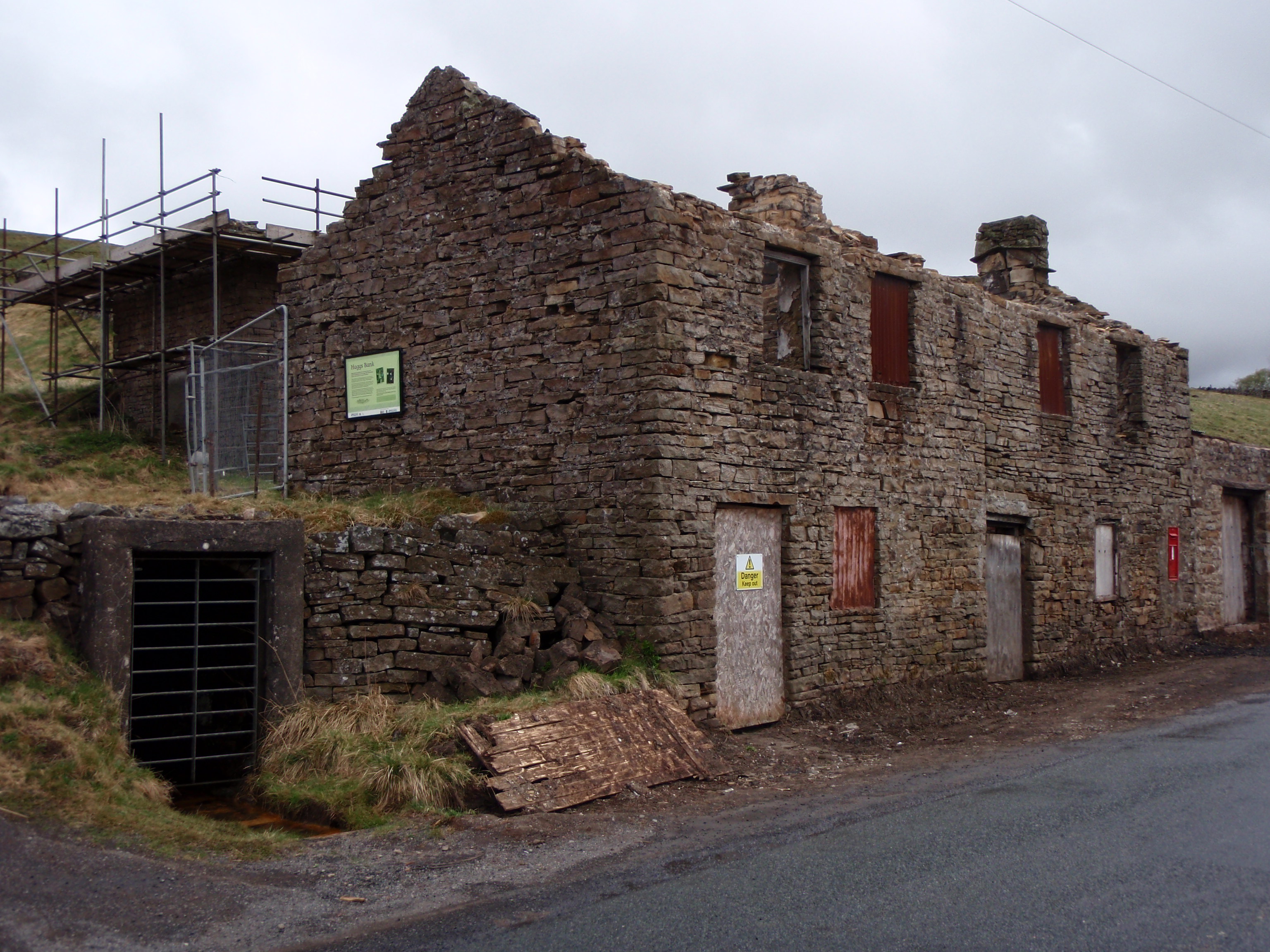
The mine portal survives, gated, beside the former mine shop buildings at Nentsberry, and the horse level behind it has collapsed; the Cumbrian side of the wider system is now reached through Brownley Hill Mine. The Nentsberry shaft into the Nent Force Level is capped and carries a viewing platform. Metal-rich mine water from this ground is one of the sites in the Mining Remediation Authority's Water and Abandoned Metal Mines Programme, which has a Nent Haggs treatment scheme in hand.
The gated portal of the horse level and the former mine shop buildings beside it at Nentsberry, and the capped Nentsberry shaft into the Nent Force Level with its viewing platform. The dressing mill that handled the mine's own ore and, from 1929, Wellhope's, stood at Nentsberry; its site is now a bus garage.
Related mines
- Brownley Hill Mine — The two mines' underground workings remain connected and passable to each other, crossing the Cumberland/Northumberland county boundary.
- Nent Force Level — The level runs through the Nentsberry Haggs ground and the mine's shaft, sunk 1811-17, is the last shaft into the canal level; the Old Cumbria Gazetteer files that shaft under the Nent Force Level's own name.
Nearby mines
- Brownley Hill Mine — 0.8 miles (1.2 km) E
- Hudgill Burn Mine — 0.9 miles (1.5 km) W
- Nenthead Mines — 1.1 miles (1.8 km) SE
- Smallcleugh Mine — 1.2 miles (1.9 km) SE
- Caplecleugh Mine — 1.3 miles (2.1 km) SE
Straight-line distance, within 9 miles (15 km). Show on the map.
Recorded claims
Individual factual claims, each attached to the source(s) that support it below. Where sources disagree, both are kept.
- The mine lies on the course of the Nent Force Level, meeting Nentsberry Haggs Shaft roughly three miles from the level's Alston entrance via a 160-foot vertical step. 1
- By 1921 Nentsberry Haggs was one of only a few mines still active in the district, alongside a brief resumption at Brownley Hill. 1
- When Wellhope Shaft began producing ore in 1929, it was brought out via the Nentsberry Haggs entrance to a dressing mill at Nentsberry; the operation was controlled by Vieille Montagne, later passing to Anglo-Austral Mines and then Rampgill Mill Limited. 1
- Between 1942 and 1945 a flotation plant processed tailings from Nentsberry together with a small output from the neighbouring Rotherhope mine. 1
- The mine's underground workings are documented in surviving mine plans held via the BGS mine plans catalogue, credited to the Cumbria Amenity Trust Mining History Society. 2
- Six tenancies are recorded in succession: the Alston Moor Mining Co. from 1821 to 1893, the Nentsbury Mining Co. Ltd 1894-1900, Alston Lead & Blende Mines Ltd 1901-02, the Nentsbury Mining Co. 1903-08, the Lugdale Chemical Co. Ltd 1909-11 and the Nentsbury Mining Co. again in 1912-13. 3
- Access was originally through the Nentsberry Haggs Horse Level, but a shaft - Wellhope - was sunk in 1925 and met the level at a depth of 416 feet. 4
- The Vieille Montagne Company took the mine over in 1913-14 and developed it heavily, finding rich oreshoots averaging six to seven feet wide with individual widths of twenty and twelve feet. 4
- Between 1923 and 1928 the mine raised 277,657 tons of crude ore, yielding 33,998 tons of lead concentrates at 80 per cent lead, nearly all of it treated at the Nentsberry mill. 4
- Between 1913 and 1938 Nentsberry produced 39,251 tons of lead concentrates and 4,152 tons of zinc concentrates, with 6.5 ounces of silver to the ton of lead - which makes it the district's last substantial lead producer. 4
- The memoir records that Vieille Montagne's underground exploration here had some success and that the mine remained a useful lead producer until 1938, yielding crude ore with up to 13.4 per cent lead sulphide. 5
- Separating blende from witherite proved difficult and ore of that mixed type was left in place. In 1942 the Ministry of Supply's Non-Ferrous Minerals Development Control established 54,000 tons of it, averaging 8.75 per cent zinc, 1.5 per cent lead and 13 per cent barium carbonate, over widths of five and eight feet - which is why a flotation plant came here during the war rather than a mine. 4
- Carr's Vein, the most important fault of the Nenthead belt, throws 216 feet north-east where the Nentsberry Haggs Level crosses it at NY 766 450. 5
- The memoir gives the strata above the Great Limestone on the High Raise Vein workings here as its typical Alston Moor section: the White Hazle sandstone at seven feet, shale, a ten-inch coal, the High Coal Sill at twelve feet, shale, a four-inch coal, the Low Coal Sill at ten feet and eighteen feet of shale. 5
- The Nentsberry shaft, the last sunk into the Nent Force Level, was put down between 1811 and 1817 to 360 feet and about ten feet in diameter, the drive continuing towards Nenthead 150 feet higher up it. It is capped, with a viewing platform. 6
Photographs & further reading
Site record for the mine, with its position, the succession of six companies from 1821 to 1913 and a bibliography of twenty-nine society newsletters, monographs and mine plans.
View sourceDunham's economic memoir of the orefield, online in full, which gives the strata at the High Raise Vein workings, the throw of Carr's Vein at the level and the mine's standing as a lead producer to 1938.
View sourceSources
- (secondary) Wright's Bus Garage - VM Zinc Mill — Alston Moor Historical Society
- (primary) NENTSBERRY HAGGS MINE NENTHEAD CUMBRIA (BGS mine plan catalogue) — British Geological Survey / Cumbrian Amenity Trust Historical Mining Society
- (secondary) Haggs — Buddlepit Mine Database — Buddlepit Mine Database
- (secondary) Lateral Science: A Couple of North Pennines Lead Mine Articles from Mine & Quarry Engineering — Lateral Science
- (primary) Northern Pennine Orefield Volume I: Tyne to Stainmore (Dunham, BGS economic memoir) — British Geological Survey
- (secondary) Old Cumbria Gazetteer: Nentsberry Haggs Shaft, Alston Moor — Old Cumbria Gazetteer
- (secondary) Vieille Montagne History — Alston Moor Historical Society
Record created: 26 August 2026 · Last researched: 28 September 2026