 MineArchive
Hudgill Burn Mine
| Location | Nentsberry, near Alston, Cumbria — 54.8028, -2.3874 (approximate) |
|---|---|
| Commodities | Lead, Zinc |
| Type | Metal |
| Worked | By 1804–1870 |
| Maximum depth | No depth figure has yet been located. |
| Operators | Flow Edge Mining Company (?–1808), John and Jacob Wilson (1812–?), Greenwich Hospital (1735–?) |
Overview
A lead mine on the north side of the Nent above Alston, reckoned the richest ever worked on Alston Moor. Given up in 1808 after four unprofitable years, it was taken on again in 1812 and within two years struck a vein of almost solid lead carbonate twenty feet wide; the duty ore it paid its landlords filled a purpose-built set of stone storage bays beside the road, which still stand.
History
The mineral rights of Alston Moor came to the Greenwich Hospital in 1735, part of the Earl of Derwentwater's estates forfeited to the Crown after the rising of 1715; the Hospital's commissioners leased the mines to companies that paid a proportion of all ore raised as rent. The Flow Edge Mining Company worked Hudgill for four years and abandoned it in 1808, having found only two weak veins. John and Jacob Wilson took the lease in 1812 and in less than two years cut a vein of solid cerussite that was twenty feet wide at one point — a strongly oxidised deposit carrying hydrozincite, smithsonite, aragonite, calcite, galena and siderite with it. The scale of the find shows in what was built for it: the Greenwich Hospital put up a set of six stone storage bays, a walled yard and a count house beside the Nent road about 1817, mainly to hold the duty ore coming from Hudgill, and in 1833 the Hudgill Mill Company was formed to smelt the mine's output, leasing the Hospital's Langley smeltmill in Northumberland and buying the Hospital's duty ore as well. Driving for the vein opened a natural limestone cavern, which a party of gentlemen was taken into in February 1818 and which was described in the Philosophical Magazine four years later: a chasm 320 yards long, three to six feet wide, its walls lined with the black sphalerite the miners called black jack and spangled with crystals. The mine closed in 1870.
Geology
The deposit lies in the Alston block of the Northern Pennine Orefield, where the veins cut the Carboniferous limestones, sandstones and shales. What made Hudgill exceptional was oxidation: the lead came largely as cerussite rather than galena, with the zinc carbonates smithsonite and hydrozincite, aragonite and calcite, and natural cavities dissolved in the limestone beside the workings.
Workings
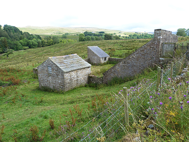
Levels and shafts on the veins north of the Nent, with a low level, a firestone level and a coal pit level among those recorded. The workings connected with a natural cavern of which more than ten kilometres has been surveyed since it was explored around 2010. Above ground the ore-storage range survives: six bays about 5 m by 4.5 m built against and revetting the road embankment, each with a 1 m chute set centrally in the 4.5 m rear wall and ending about 2 m above the floor, the north-western three still roofed with stone slabs. They form one side of a walled courtyard about 16 m square, half of it paved with large slabs; a single-storey building by the only gateway is read as the count house, and a smaller one in the east corner as a tool store.
Closure
The mine closed in 1870, after the carbonate ore that had made its reputation was worked out; no account of a final year's output has been found.
What remains
The bingsteads, courtyard, count house and tool store are a scheduled monument and stand largely complete, three of the six bays keeping their stone-slab roofs and the two small buildings most of their slates. The mine workings themselves are not part of the scheduling.
The storage bays and their chutes, the walled and part-paved courtyard, the count house and tool store, and the grassed-over slabs that cover the chute tops between the bays and the road.
Redevelopment
None. The bays and yard stand as built beside the road.
Nearby mines
- Nentsberry Haggs Mine — 0.4 km N
- Holyfield Mine — 1.9 km W
- Carshield Mine — 2.1 km NE, Northumberland
- Blagill Mine — 2.2 km NW
- Brownley Hill Mine — 2.7 km E
Straight-line distance, within 15 km. Show on the map.
Recorded claims
Individual factual claims, each attached to the source(s) that support it below. Where sources disagree, both are kept.
- The mineral rights of Alston Moor passed to the Greenwich Hospital in 1735 with the Derwentwater estates forfeited after the 1715 rising; its lessees paid a proportion of all ore raised as rent. 1
- The Flow Edge Mining Company abandoned Hudgill Burn in 1808 after working it for four years and finding only two weak veins. 2
- John and Jacob Wilson took the lease in 1812 and in less than two years hit a vein of solid cerussite twenty feet wide at one point. 2
- The bingsteads beside the Nent road were built about 1817 by the Greenwich Hospital, mainly to store the large quantities of duty ore coming from Hudgill Mine. 1
- The Hudgill Mill Company, formed in 1833 to smelt the mine's ore, leased the Greenwich Hospital's Langley smeltmill and also bought the Hospital's duty ore. 1
- A party taken into the mine on 19 February 1818 found a newly opened limestone cavern whose main chasm ran 320 yards, lined with sphalerite and crystalline spar. 3
- The mine closed in 1870. 2
Photographs & further reading
The locality record for the mine, with its mineral list and a reprint of the 1822 Philosophical Magazine account of the cavern found in the workings.
View sourceThe British Geological Survey's catalogue entry for a plan of the mine, one of six catalogue records naming Hudgill.
View sourceSources
- (primary) Hudgill lead mine bingsteads, 200m north east of Hudgill Farm, Alston Moor (List entry 1017449) — Historic England
- (secondary) Alston Moor: mines and minerals — Steetley Minerals
- (secondary) Hudgill Burn Mine, Alston Moor, Eden, Cumbria — Mindat
- (observational) Hudgill Burn Mine Cavern — Council for the Northern Caving Community
- (primary) Abandoned mine plan catalogue entry: PLAN OF HUDGILL BURN LEAD MINE — British Geological Survey
Record created: 22 September 2026 · Last researched: 22 September 2026