 MineArchive
Groverake Mine
| Also known as | Grove Rake, Grove Heads |
|---|---|
| Location | Rookhope, Weardale, County Durham — 54.7926, -2.1586 (approximate) |
| Commodities | Fluorspar, Iron, Lead |
| Type | Mineral |
| Worked | From 1819–1999 |
| Operators | W. B. Lead Company (1819–1883), Weardale Lead Company (1880–1919), Groverake Mining Company (1930–?), British Steel Corporation (1970–1983), Sherburn Minerals (1991–1999) |
Overview
A Weardale mine worked in succession for three different minerals — ironstone, then lead, then fluorspar — closing in 1999 as the last working deep mineral mine in County Durham, and now the site of the last surviving headgear in the North Pennines.
History
Groverake was worked for ironstone from 1819, then for lead, passing through the Beaumont Company from the late 1810s and the Weardale Lead Company from the mid-1880s. As a lead mine it was never a large producer — some 6,498 tons of lead concentrates between 1818 and 1883. Lead working ended around 1919; the mine was reopened in the 1930s, by the Groverake Mining Company, to work fluorspar instead, and changed hands repeatedly over the following decades — Blanchland Fluor Mines, later the British Steel Corporation, then Weardale Minerals and Processing Company from the early 1980s. That parent company's receivership in 1991 passed the mine to Sherburn Minerals, who worked it until closure in the summer of 1999. Under British Steel and its successors the fluorspar proved rich enough to make Groverake the leading commercial producer in Weardale through the 1980s and 1990s, after earlier attempts had been held back by the difficulty of separating silica from the ore.
Geology
Groverake sits in the fluorite-rich inner zone of the Northern Pennine Orefield, on the Alston Block. The veins occupy normal faults cutting Carboniferous strata, and were at their widest and richest where those faults pass through hard limestone — the Great Limestone above all, which also hosts horizontal replacement bodies known locally as flats. The mineral zoning of the orefield, from a fluorite-and-quartz core outwards through lead and zinc to a barium-mineral fringe, reflects fluids cooling as they moved outwards from emanative centres above high points on the concealed Weardale Granite; the granite is generally read as the heat source driving that circulation rather than necessarily the source of the metals themselves.
Geological setting: Hydrothermal Deposits (well documented example), Veins and Lodes (well documented example)
Workings
The mine stands where the Groverake, Greencleugh and Red veins converge, with the Burtree Pasture vein meeting them at the same point. Two shafts were sunk on the Red and Groverake veins by the Beaumont Company, reaching levels in and below the Great Limestone. Under the British Steel Corporation the Rake level was driven northward and the Firestone dib decline developed, though neither ever connected with the shaft-accessed workings. From 1983 Weardale Mining & Processing linked Groverake underground to the neighbouring Frazer's Hush mine by a 2 ft gauge railway worked by battery-electric locomotives.
Closure
The parent company's receivership in 1991 passed the mine to Sherburn Minerals, who worked it until closure in the summer of 1999.
What remains
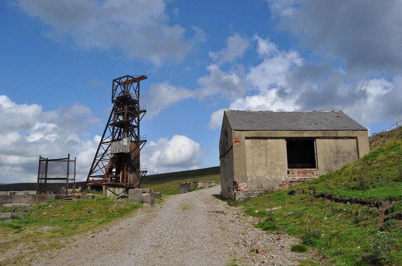
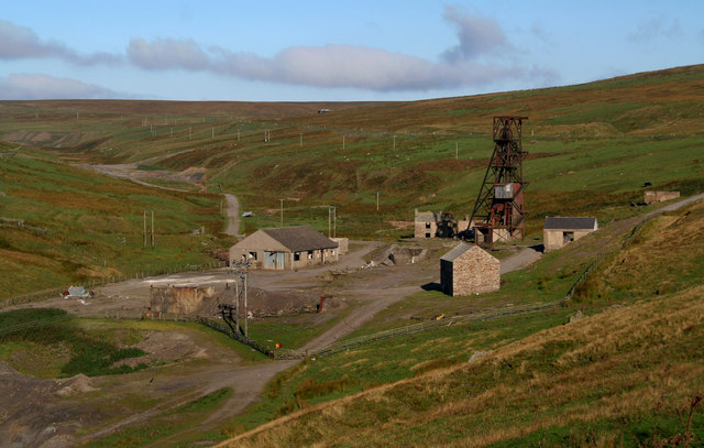
Widely reported as the last working deep mineral mine in County Durham at its 1999 closure. Its steel headgear — brought to the site by the British Steel Corporation from a colliery — is the last surviving example of its kind in the North Pennines. Durham County Council placed a building preservation notice on the winding house in 2013, describing the surviving structures as a unique collection; the site was nonetheless vandalised in 2015 and stripped by scrap thieves before a community campaign secured the remaining headstocks in 2017. A visitor in 2008 described the headgear as ramshackle and audibly deteriorating in the wind, and a June 2020 report found the site much reduced but the headgear still standing over an open shaft.
The headgear and winding house, remains of the processing plant, adit and shaft entrances and extensive spoil heaps, in open moorland between Rookhope and Allenheads.
Related mines
- Blanchland Fluor Mines — Both worked the North Pennine fluorspar zone in the twentieth century after their lead had gone, and both passed through British Steel Corporation ownership; Blanchland is named on the Groverake record.
- Frazer's Hush Mine — Linked underground from 1983 by a battery-electric railway.
- Rookhope (Boltsburn Mine) — Both were Weardale Lead Company mines in Rookhope, a few kilometres apart on the same fluorspar-rich ground; the British Geological Survey's excursion guide treats them as consecutive stops.
- Wolfcleugh Mine — Neighbours in the Rookhope valley — Wolfcleugh lies between Redburn and Groverake — and both were held by the Weardale Lead Company and both were carried by it from lead into fluorspar — it reopened Wolfcleugh in 1901 for exactly the mineral that kept Groverake working long afterwards.
Nearby mines
- Frazer's Hush Mine — 0.9 miles (1.5 km) W
- Lintzgarth Mine — 1.6 miles (2.5 km) SE
- Wolfcleugh Mine — 1.7 miles (2.8 km) SE
- Redburn Mine — 1.9 miles (3.1 km) E
- Allenheads Mines — 2.5 miles (4.0 km) W, Northumberland
Straight-line distance, within 9 miles (15 km). Show on the map.
What's uncertain
Points where sources disagree or the record could not be settled; both accounts are kept. All open questions in the archive.
- Groverake was worked for ironstone from 1819 before later becoming a lead, then fluorspar, mine. (uncertain) 1,2
- As a lead mine Groverake produced only about 6,498 tons of lead concentrates between 1818 and 1883. (uncertain) 4
- From 1983 Groverake was connected underground to Frazer's Hush mine by a 2 ft gauge battery-electric railway. (uncertain) 4,5
- Durham County Council served a building preservation notice on the winding house in 2013; the site was vandalised and stripped by scrap thieves in 2015 before the headstocks were secured by a community campaign in 2017. (uncertain) 6
Recorded claims
Individual factual claims, each attached to the source(s) that support it below. Where sources disagree, both are kept.
- Groverake was worked for ironstone from 1819 before later becoming a lead, then fluorspar, mine. (uncertain) 1,2
- The mine's steel headgear, brought from a colliery by the British Steel Corporation, is the last surviving example of its kind in the North Pennines and was saved from demolition in 2017. 3
- As a lead mine Groverake produced only about 6,498 tons of lead concentrates between 1818 and 1883. (uncertain) 4
- From 1983 Groverake was connected underground to Frazer's Hush mine by a 2 ft gauge battery-electric railway. (uncertain) 4,5
- The mine lies at the junction of the Groverake, Greencleugh and Red veins, worked in and below the Great Limestone. 4,6
- Durham County Council served a building preservation notice on the winding house in 2013; the site was vandalised and stripped by scrap thieves in 2015 before the headstocks were secured by a community campaign in 2017. (uncertain) 6
- Six mine plans and mine-entry plans naming Groverake are catalogued by BGS, including a section of the Groverake shaft and workings and a plan of the Rispey Water Level. 7
- Northern Pennine Orefield mineralisation is zoned outwards from fluorite-rich centres above cupolas on the concealed Weardale Granite, the granite acting principally as a heat source. 8
- The Durham Mining Museum's year-by-year list of the Weardale Lead Mining Company's mines carries 'Grove Heads' in Weardale in 1883, 1885, 1887 and 1888, and 'Groverake' in the same position in the same list from 1894 onwards; no year lists both. 9
- The company's returns record Groverake with 114 men underground and 61 at the surface in 1894, 45 and 30 in 1896, 14 and 13 in 1899, and 12 underground in 1900. 9
Photographs & further reading
Detailed site history with photographs of the headgear and surface plant.
View sourceDated exploration report on the surviving headgear and surface remains.
View sourceSite history with a surface exploration of the remaining structures.
View sourceSources
- (secondary) Groverake Mine, Weardale — Northern Mine Research Society
- (primary) Durham Mining Museum - Weardale Lead Co., Ltd. — Durham Mining Museum
- (observational) Groverake Mine in Rookhope — Atlas Obscura
- (secondary) Grove Rake Fluorspar Mine, County Durham — The View From the North
- (observational) Groverake Mine, Rookhope, Weardale, June 2020 — 28DaysLater
- (observational) Groverake Mine — GooseyGoo
- (primary) Mine plan: SECTION OF GROVERAKE SHAFT AND WORKINGS — BGS / Mining Remediation Authority mine plans catalogue
- (secondary) The Northern Pennine Orefield: Weardale and Nenthead — Yorkshire Geological Society / GeoGuide
- (primary) Weardale Lead Mining Co., Ltd. — collieries and mines owned, by year — Durham Mining Museum
Record created: 25 August 2026 · Last researched: 25 August 2026