 MineArchive
Redburn Mine
| Location | Rookhope, Weardale, County Durham — 54.7828, -2.1136 (approximate) |
|---|---|
| Commodity | Fluorspar |
| Type | Metal |
| Worked | 1930s–1981 |
| Maximum depth | 98 m shaft (levels at 17, 34, 40 and 50 fathoms) |
| Operators | Hogarth, Forster & Hogarth (?–1936), Weardale Lead Company (1964–1981) |
Overview
The first new mine opened in Weardale in the twentieth century: a fluorspar mine driven into an unworked length of the Red Vein at Rookhope in September 1964 on the strength of Sir Kingsley Dunham's surveys, shaft-wound from 1968, and worked out by 1981.
History
Redburn Mine was cut into a section of the Red Vein beginning about a kilometre west of the village of Rookhope in Weardale, and it is one of the very few mines in the dale of entirely modern origin. Surveys by Sir Kingsley Dunham had suggested that commercial-grade fluorspar might lie along an unproven length of the Red Vein between the Groverake and Boltsburn mines, and in September 1964 the Weardale Lead Company drove an inclined drift in to find out. It reached a substantial vein of fluorite at the base of the Great Limestone. It was the first new mine opened in Weardale that century. Two productive ore zones were found. The western one is a complex network of interconnected veins, thirteen separate branches of which were worked, with widths reaching six metres; run-of-mine grades varied between 30 and 60 per cent calcium fluoride and individual stopes could average as much as 80. Lead was present at only about 2.4 per cent and could never have repaid working on its own - the reverse of the old Weardale economy, in which fluorspar had been a useless gangue mineral in the lead veins. A mineralised section was worked for over 300 metres west with levels reaching down to the Five Yard Limestone, and a second section, found 1,200 metres west of the first, was worked a further 610 metres from levels largely in the Great and Little Limestones. In 1967-68 a shaft 98 metres deep was sunk to replace the drift entrance, with levels off at 17, 34, 40 and 50 fathoms. It was wound by a Tinsley double-drum 80-horsepower engine brought over from East Tanfield Colliery, and underground haulage on the 17 and 40 levels was by electric locomotive. The mine was worked by classical shrinkage stoping with sub-levels at twenty-five to thirty metre intervals, and had produced 247,217 tonnes of ore by the end of 1976. It was later taken over by SAMUK. Extraction is reported to have been very thorough. The mine closed in 1981, its economic reserves considered depleted.
Geology
Worked fluorspar from the Red Vein between the Groverake and Boltsburn mines, the vein reached at the base of the Great Limestone. The western ore zone is a network of interconnected veins up to six metres wide across thirteen worked branches, with levels extending down to the Five Yard Limestone; a second zone 1,200 metres further west was worked largely from levels in the Great and Little Limestones. Run-of-mine grades ran from 30 to 60 per cent calcium fluoride, with a lead content of about 2.4 per cent.
Workings
Entered by an inclined drift from September 1964 and from 1967-68 by a shaft 98 metres deep with levels off at 17, 34, 40 and 50 fathoms, wound by a Tinsley double-drum 80-horsepower engine brought from East Tanfield Colliery. Haulage on the 17 and 40 levels was by electric locomotive, and the ground was taken by classical shrinkage stoping with sub-levels at twenty-five to thirty metre intervals.
Closure
The mine closed in 1981, its economic reserves considered depleted after what is reported to have been very thorough extraction.
What remains
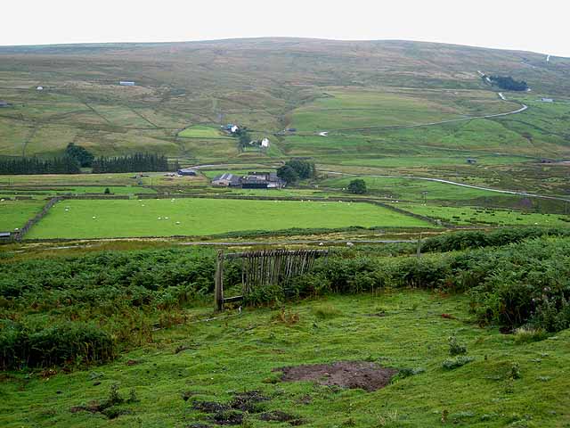
The site lies on the floor of the Rookhope valley.
Buildings stand on the mine site on the floor of the Rookhope valley.
Redevelopment
Unknown.
Nearby mines
- Lintzgarth Mine — 0.6 km W
- Rookhope (Boltsburn Mine) — 1.0 km E
- Wolfcleugh Mine — 2.2 km SW
- Stotsfield Burn Mine — 2.4 km S
- Brandon Walls Mine — 2.8 km S
Straight-line distance, within 15 km. Show on the map.
Recorded claims
Individual factual claims, each attached to the source(s) that support it below. Where sources disagree, both are kept.
- Redburn Mine was reopened by the Weardale Lead Company in September 1964 from an inclined drift on the Red Vein, the first new mine opened in Weardale in the twentieth century. 1
- The Redburn Shaft, ninety-eight metres deep, was sunk in 1967-68, with levels at 17, 34, 40 and 50 fathoms. 1
- Worked fluorspar at run-of-mine grades of about thirty to sixty per cent calcium fluoride, the acid-grade output going chiefly to ICI at Runcorn. 1
- Fluorspar was worked here in the 1930s under Hogarth, Forster & Hogarth, the mine being abandoned in September 1936. 2
- The mine closed in 1981 when its economic reserves were considered worked out. 1
- Surveys by Sir Kingsley Dunham suggested commercial-grade fluorspar along an unproven length of the Red Vein between the Groverake and Boltsburn mines. The Weardale Lead Company began an inclined drift in September 1964 and struck a substantial vein of fluorite at the base of the Great Limestone; it was the first new mine opened in Weardale that century. 1,3
- Two productive ore zones were developed. The western zone is a complex network of interconnected veins, thirteen branches of which were worked, with widths up to six metres, run-of-mine grades of 30 to 60 per cent calcium fluoride and stopes averaging as much as 80. The lead content was about 2.4 per cent and could never have repaid working by itself. 1
- Redburn Shaft, 98 metres deep, was sunk in 1967-68 to replace the drift entrance, with levels off at 17, 34, 40 and 50 fathoms and a Tinsley double-drum 80-horsepower winding engine brought from East Tanfield Colliery. Haulage on the 17 and 40 levels was by electric locomotive and the mine was worked by classical shrinkage stoping with sub-levels every twenty-five to thirty metres. 1
- Total ore production to the end of 1976 was 247,217 tonnes. 1
Photographs & further reading
Owners, output and the roll of those killed at the Redburn fluorspar mine.
View sourceSources
- (secondary) BRITISH MINING No.5: Weardale — Northern Mine Research Society
- (primary) Redburn (Fluorspar) (DMM r914) — Durham Mining Museum
- (secondary) Redburn Mine, Rookhope, Stanhope, County Durham — Mindat
- (primary) Redburn Mine (The Weardale Lead Co. Ltd.) abandonment plans (BGS mine-plans catalogue) — British Geological Survey
Record created: 23 September 2026 · Last researched: 23 September 2026