 MineArchive
Lintzgarth Mine
| Also known as | Lintzgarth |
|---|---|
| Location | Lintzgarth, Rookhope, Weardale, County Durham — 54.7835, -2.1226 (approximate) |
| Commodity | Lead |
| Type | Metal |
| Worked | 1930–June 1930 |
| Maximum depth | Unknown. |
| Operators | Weardale Lead Company (1930–?) |
Overview
Lintzgarth appears in the 1930 List of Mines as a Weardale Lead Company working at Rookhope with six men underground and four at the surface, developing rather than producing, and suspended in June of that year. It sits at the place the company had smelted the ore of the whole dale until 1919 — the Rookhope, or Lintzgarth, smelt mill, the last one working in the North Pennine orefield, whose single surviving flue arch still stands beside the burn.
History
The 1930 List of Mines under the Metalliferous Mines Act enters Lintzgarth at Rookhope, owned by the Weardale Lead Co. Ltd of Wearhead with H. S. Willis as agent, six men underground and four at the surface, working lead ore — and against the working-status column, 'Developing, operations suspended 6/30'. That is the whole of what has been established about the venture itself: a company opening ground, and stopping within the year.
The place is another matter. Lintzgarth is where the lead of Rookhope and Weardale was smelted. The mill stood immediately south of the arch that survives beside the road, and it processed ore from the mines the Weardale Lead Company worked across the dale until 1919 — the last working smelt mill in the whole North Pennine orefield. Like every large Pennine smelter it carried its fumes away up the fell: a horizontal flue ran from the hearths, over the Rookhope to Allenheads road and the Rookhope Burn on a viaduct of six arches, into twin bores and on up the hillside to a chimney on Redburn Common, a mile and a half away. The point was partly the smelters' health and partly money — lead and silver vaporised in the fumes condensed on the flue walls, and the dust was scraped down, flushed out with water, settled in tanks and put back through the mill.
By the time six men were opening ground at Lintzgarth in 1930 the smelting had been over for eleven years and the dale's mining was nearly done with it. Boltsburn, a mile up the valley at Rookhope village and the last major lead mine in the dale, closed in 1931.
Geology
Rookhope lies in the central part of the North Pennine orefield, where the lead occurs in near-vertical veins cutting a Carboniferous sequence of limestones, sandstones and shales, and in 'flats' — replacement bodies spreading out from a vein where it crosses a favourable bed, most productively the Great Limestone. That is the ground Boltsburn worked a mile away, and the flats there were famous for fluorite. The east-west 'Quarter-Point' veins of this district, along which the movement was horizontal rather than vertical, have been the orefield's main source of fluorspar in modern times. No source names the vein Lintzgarth was developing on.
Geological setting: Veins and Lodes (historical documentary reference)
Workings
Unknown. The record gives no more than the return's own figures: six men underground and four at the surface in 1930. A venture recorded as developing had by definition not reached production, and nothing on record describes its shafts or levels.
Closure
Operations were suspended in June 1930, within the year of the return that records them. Nothing on record establishes whether work resumed.
What remains
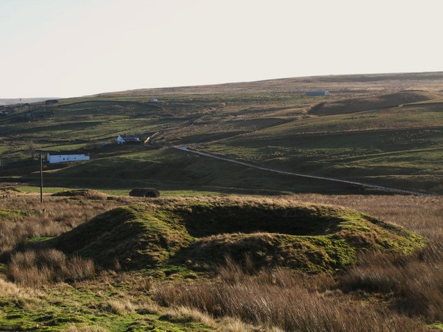
The ground north-west of Lintzgarth carries old shaft workings, the collapsed 'craters' of which are visible on the fellside above the hamlet. The arch of the smelt-mill flue survives beside the Rookhope Burn and is a Grade II listed building, and the line of the flue can still be followed up towards Redburn Common.
The single surviving arch of the smelt mill's flue viaduct — semicircular, about three metres in radius and three metres thick, of sandstone rubble with ashlar dressings, an 1802 addition to the 1737 mill — together with the entrance to the twin flue bores, just. The mill itself stood immediately to the south and has gone. The hollows and spoil rims of old shafts survive on the fell above.
Related mines
- Rookhope (Boltsburn Mine) — Both worked in Rookhope under the Weardale Lead Company, and the ore of both was smelted at the company's mill at Lintzgarth until it closed in 1919. Boltsburn, a mile up the valley, was the last major lead mine in the dale and closed in 1931, the year after Lintzgarth's development was suspended.
Nearby mines
- Redburn Mine — 0.4 miles (0.6 km) E
- Rookhope (Boltsburn Mine) — 1.0 miles (1.5 km) E
- Wolfcleugh Mine — 1.2 miles (1.9 km) SW
- Groverake Mine — 1.6 miles (2.5 km) NW
- Stotsfield Burn Mine — 1.6 miles (2.6 km) SE
Straight-line distance, within 9 miles (15 km). Show on the map.
What's uncertain
Points where sources disagree or the record could not be settled; both accounts are kept. All open questions in the archive.
- The BGS mine-plans catalogue holds a Mining Remediation Authority abandonment plan titled 'Lintzgarth' (catalogue OM11734, Silica And Iron Ore, dated 1930); the catalogue gives no location and the plan's details do not clearly tie it to this working, so it may belong to another of the same name. (uncertain) 5
Recorded claims
Individual factual claims, each attached to the source(s) that support it below. Where sources disagree, both are kept.
- The 1930 List of Mines records Lintzgarth at Rookhope, owned by the Weardale Lead Co., Ltd. of Wearhead with H. S. Willis as agent, six men underground and four at the surface, working lead ore, and 'Developing, operations suspended 6/30'. 1
- The Rookhope, or Lintzgarth, smelt mill stood immediately south of the surviving flue arch and processed lead ores from mines in Rookhope and Weardale operated by the Weardale Lead Company until 1919; it was the last working smelt mill in the orefield. 2
- The surviving arch is an 1802 addition to the 1737 mill: a semicircular arch of about three metres radius in a rubble wall about three metres thick, of sandstone rubble with ashlar dressings, listed Grade II on 5 June 1987. 3
- Six arches carried the flue over the Rookhope to Allenheads road and the Rookhope Burn to twin bores, and the flue ran a mile and a half up the fellside to a chimney on Redburn Common; lead and silver condensed on the flue walls were scraped down, flushed out with water, settled in tanks near the mill and recycled through it. 2,4
- Boltsburn Mine at Rookhope village, the last major lead mine in the valley, worked the Boltsburn Vein and its flats in the Great Limestone and closed in 1931. 2
- The BGS mine-plans catalogue holds a Mining Remediation Authority abandonment plan titled 'Lintzgarth' (catalogue OM11734, Silica And Iron Ore, dated 1930); the catalogue gives no location and the plan's details do not clearly tie it to this working, so it may belong to another of the same name. (uncertain) 5
Photographs & further reading
A field itinerary through the middle of the orefield that stops at Lintzgarth, Rookhope village and Groverake in turn, explaining what is visible at each and how the veins, the flats in the Great Limestone and the Weardale Granite beneath them relate.
View sourceSources
- (primary) 1930 List of Mines under the Metalliferous Mines Act: Durham — Durham Mining Museum
- (primary) Northern Pennine Orefield: Weardale and Nenthead — an excursion — Brian Young, British Geological Survey, in Northumbrian Rocks and Landscape (Yorkshire Geological Society)
- (primary) Arch of former Lintzgarth smelt-mill flue, Stanhope (listed building 1277257) — Historic England, via British Listed Buildings
- (secondary) Running on Fumes — the Rookhope Chimney — Weardale UK
- (primary) BGS / Mining Remediation Authority mine plans: LINTZGARTH — British Geological Survey / Mining Remediation Authority
Record created: 5 September 2026 · Last researched: 6 September 2026