 MineArchive
Burtree Pasture Mine
| Location | Cowshill, Weardale, County Durham — 54.7642, -2.2189 (approximate) |
|---|---|
| Commodities | Lead, Fluorspar |
| Type | Metal |
| Worked | By 1800–c. 1980 |
| Maximum depth | At least 74 m: the Level Head Engine Shaft was secured to Gargett's Level at that depth in the 1970s. |
| Operators | Weardale Lead Company (1883–1887), Weardale Lead Company (1971–?), W. B. Beaumont (?–1883) |
Overview
A lead mine just north of Cowshill at the head of Weardale, one of the dale's great 19th-century producers, which raised about 175,000 tons of lead concentrates on the Burtree Pasture Vein between 1818 and 1890. The Weardale Lead Company reopened it in 1971 to work fluorspar, much of it waste the old lead miners had packed back into their stopes, and it closed for good around 1980.
History
The mine worked the Burtree Pasture Vein on the Blackett-Beaumont leases in Weardale, first granted to Sir William Blackett by the bishops of Durham in 1698. Lead miners were stoping the vein by 1800: waste fluorspar they back-filled into the old stopes between about 1800 and 1825 was dug out again more than 150 years later. J. E. Metcalfe, writing in 1952, gives the mine's output between 1818 and 1890 as about 175,000 tons of concentrates, and by then its workings had been connected with those on the neighbouring Breckonsike Vein. W. B. Beaumont is recorded as owner in the 1880s; the Weardale Lead Company was formed in June 1883 to take over the Beaumont mines and leases in Weardale, and its own record gives Burtree Pasture 904 tons of lead concentrates and a closure in 1887, though the mine returned lead ore in 1888 and 1890 and was standing idle in the 1890s. The company, in which ICI took a majority interest in 1962, began reopening the mine in 1971 in search of fluorspar. The Level Head Engine Shaft was fitted with a 300 hp Robey hoisting engine brought from Kimblesworth Colliery and widened and secured for 74 metres down to Gargett's Level, and the old back-filled fluorspar, running at 30 to 80 per cent calcium fluoride, was drawn off by draw-point loading. The ore went by lorry to the company's Boltsburn mill at Rookhope. Fluorspar and galena were still being raised in 1979 and 1980, and the mine closed around 1980; local accounts say the 1980s.
Geology
The mine worked the Burtree Pasture Vein, a lead vein carrying galena with abundant fluorspar, which the 19th-century lead miners treated as waste; its workings joined those on the Breckonsike Vein. BGS holds plans of the mine showing a proposed trial below the Whin Sill, and a section of the strata at the mine.
Geological setting: Veins and Lodes (well documented example)
Workings
Levels and stopes on the Burtree Pasture Vein, with the Level Head Engine Shaft and levels including Gargett's Level and the Firestone Level. In the 1970s reopening the engine shaft was widened and secured for 74 metres to Gargett's Level and an underground hoisting engine installed, and the old back-filled stopes were worked by draw-point loading.
Closure
The 19th-century lead mine closed in 1887 by the Weardale Lead Company's own record, though it returned ore in 1888 and 1890 before standing idle through the 1890s. After the fluorspar reopening that began in 1971 the mine was still producing in 1979 and 1980 and closed around 1980, which other local accounts give as the 1980s.
What remains
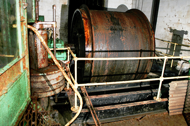
The main entrance adit has collapsed. A 2009 report found the underground winding system still in place, with much of the mine in good condition but a lot of the timber rotten and most of the workings under water; a 2007 photograph shows the winder in its chamber. At the surface the mine's old amenity block is used as a workshop, with a shaft sheave wheel standing beside it, and the fenced shaft is one of the few other signs of the mine in a 2014 photograph.
The former amenity block, now a workshop, a shaft sheave wheel beside it, and the fenced engine shaft.
Redevelopment
The mine's amenity block has been reused as a workshop.
Related mines
- Rookhope (Boltsburn Mine) — Both Weardale Lead Company mines; ore from the 1970s Burtree Pasture reopening was taken to the company's Boltsburn mill at Rookhope.
Nearby mines
- High Sedling Mine — 1.6 km NW
- Blackdene Mine — 2.3 km SE
- Sedling Rake Mine — 2.3 km SW
- Frazer's Hush Mine — 4.1 km NE
- Killhope Lead Mine — 4.1 km NW
Straight-line distance, within 15 km. Show on the map.
People
- W. B. Beaumont · owner, to 1883 — via the operator record
What's uncertain
Points where sources disagree or the record could not be settled; both accounts are kept. All open questions in the archive.
- The Weardale Lead Company closed the mine in 1887, having raised 904 tons of lead concentrates. (disputed) 2
- Lead ore was returned from the mine in 1888 and 1890, and it was standing idle in 1894, 1896 and 1900. (disputed) 1,3
- The mine closed about 1980. (disputed) 3,4
- The mine was in operation until the 1980s. (disputed) 5,6
Recorded claims
Individual factual claims, each attached to the source(s) that support it below. Where sources disagree, both are kept.
- Burtree Pasture Mine principally worked the Burtree Pasture Vein and produced about 175,000 tons of concentrates between 1818 and 1890. 1
- Lead miners back-filled waste fluorspar into the old stopes between about 1800 and 1825. 2
- The Weardale Lead Company closed the mine in 1887, having raised 904 tons of lead concentrates. (disputed) 2
- Lead ore was returned from the mine in 1888 and 1890, and it was standing idle in 1894, 1896 and 1900. (disputed) 1,3
- W. B. Beaumont and then the Weardale Lead Mining Co. Ltd are recorded as owners in the 1880s. 3
- Reopening of the old Burtree Pasture lead mine for fluorspar began in 1971; the Level Head Engine Shaft was re-equipped with a 300 hp Robey hoisting engine from Kimblesworth Colliery and secured for 74 m to Gargett's Level. 2
- Back-filled fluorspar grading 30 to 80 per cent CaF2 was mined by draw-point loading and taken by lorry to Boltsburn mill at Rookhope. 2
- The mine closed about 1980. (disputed) 3,4
- The mine was in operation until the 1980s. (disputed) 5,6
- In 2009 the main entrance had collapsed, the underground winding system was still in place and most of the workings were under water. 5,7
Photographs & further reading
A 1976 journal article on the mine; paywalled, not read for this record.
View sourceSources
- (secondary) Lateral Science: A Couple of North Pennines Lead Mine Articles from Mine & Quarry Engineering — Lateral Science
- (secondary) BRITISH MINING No.5: Weardale — Northern Mine Research Society
- (secondary) Burtree Pasture (Lead Ore) — Durham Mining Museum
- (observational) Workshop at Burtree Pasture (photograph) — Geograph Britain and Ireland
- (observational) Report - Burtree Pasture Mine Weardale (2009) — 28DaysLater
- (observational) Burtree Pasture mine — Heather in Cowshill (blog, 2014)
- (observational) Winder: Burtree Pasture Mine (photograph, 2007) — Geograph Britain and Ireland
- (primary) BGS mine plans: Burtree Pasture Mine — British Geological Survey
Record created: 18 September 2026 · Last researched: 18 September 2026