 MineArchive
Sedling Rake Mine
| Also known as | Sedling Mine |
|---|---|
| Location | Sedling Vein, near Cowshill, County Durham — 54.7642, -2.2196 (exact) |
| Commodities | Lead, Fluorspar |
| Type | Metal |
| Worked | 1818–1948 |
| Maximum depth | Unknown. |
| Operators | W. B. Lead Company (1818–1878), Weardale Lead Company (1900–1948) |
Overview
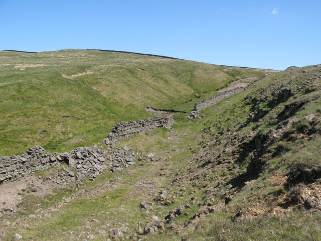
A Weardale lead mine near Cowshill, worked by the Beaumont Company for lead through most of the 19th century and later reopened by the Weardale Lead Company for fluorspar, its old packhorse track still visible today as a green lane across the moor.
History
Sedling Mine, on Sedling Vein near Cowshill in Weardale, was worked by the Beaumont Company from 1818 to 1878, primarily for lead, producing some 10,411 tons of lead concentrates over that sixty-year span. The mine was later reopened by the Weardale Lead Company between 1900 and 1948 to work the ground for fluorspar instead, following the same pattern seen elsewhere in the district of lead workings finding a second life once fluorspar itself became commercially valuable. 'Sedling Rake' itself refers to the old packhorse track that ran through the mining area, still visible today as a green lane crossing the moor. The site today consists mostly of grassed-over spoil dumps.
Geology
The Sedling Vein near Cowshill in Weardale, worked for lead through the 19th century and later for the fluorspar in the same ground.
Workings
Worked via Sedling Vein for lead (1818-1878, 10,411 tons of concentrates) and later fluorspar (1900-1948).
Closure
Lead working under the Beaumont Company ran 1818-1878; the mine was reopened for fluorspar by the Weardale Lead Company from 1900, finally closing in 1948. Mine and Quarry Engineering gives the Weardale Lead Company's lead output for 1889 to 1938, and the Northern Mine Research Society lists the company's tenure from 1896, so the fluorspar years began before 1900 by those accounts.
What remains
Mostly grassed-over spoil dumps survive; the old packhorse track, Sedling Rake itself, remains visible as a green lane across the moor.
Grassed-over spoil dumps and the trackbed of the old packhorse route, Sedling Rake.
Related mines
- High Sedling Mine — Both are workings on the Sedling ground at Cowshill and both were returned in the statutory lists under their own names — Sedling Rake worked by the Beaumont Company for lead from 1818 and reworked for fluorspar by the Weardale Lead Company to 1948, High Sedling held in 1930 by Hinchcliffe Brothers of Sheffield for fluorspar. Whether they worked the same ground at different levels is not established by anything read here.
Nearby mines
- Burtree Pasture Mine — 0.0 miles (0.0 km) E
- High Sedling Mine — 1.0 miles (1.6 km) NW
- Blackdene Mine — 1.4 miles (2.3 km) SE
- Killhope Lead Mine — 2.4 miles (3.8 km) NW
- Frazer's Hush Mine — 2.6 miles (4.2 km) NE
Straight-line distance, within 9 miles (15 km). Show on the map.
Recorded claims
Individual factual claims, each attached to the source(s) that support it below. Where sources disagree, both are kept.
- The Beaumont Company worked Sedling Mine for lead from 1818 to 1878, producing 10,411 tons of concentrates. 1
- 'Sedling Rake' refers to the old packhorse track through the mining area, still visible today as a green lane across the moor. 2
- Mine and Quarry Engineering in January 1952 gave the Beaumont Company's output for 1818 to 1878 as 10,411 tons of concentrates and the Weardale Lead Company's as 6,159 tons between 1889 and 1938; between 1900 and 1916 galena, at 2,708 tons, was only about four per cent of the output against 49,732 tons of fluorspar, and from 1900 to 1940 the fluorspar total was 145,477 tons, treated in a small modern mill. 3
- Northern Mine Research Society data places the mine at NY 8597 4105, 408 metres up beside Sedling Burn below Burtreepasture, with the Weardale Lead Mining Co. Ltd holding it from 1896 to 1913 and the Weardale Lead Co. Ltd from 1914 to 1950, its dumps now mostly grassed over. 4
- The British Geological Survey holds a plan of Sedling Mine catalogued for fluorspar, zinc and lead (MP18749), sections on the line of the Sedling vein and of New Sedling, a section of proposed development below water level and a plan of a proposed incline from the level mouth to the crushing mill. 5
Photographs & further reading
The article's account of Sedling's lead and fluorspar output.
View sourceSources
- (secondary) Sedling Mine, Cowshill, Stanhope, County Durham — Mindat
- (secondary) Burtree Fell, Cowshill mines, Sedling Fell — Boyd Harris (Weardale walking/history site)
- (primary) Mine and Quarry Engineering, January 1952: North Pennine lead mines (Durham Mining Museum transcription) — Durham Mining Museum
- (secondary) Sedling Mine (Buddlepit Mine Database, from Northern Mine Research Society data) — Buddlepit / Mining History Trust
- (primary) Sedling Mine plans and sections, MP18749 and others (BGS mine plans catalogue) — British Geological Survey
Record created: 1 September 2026 · Last researched: 24 September 2026