 MineArchive
Arkwright Colliery
| Location | Arkwright Town, Sutton cum Duckmanton, near Chesterfield, Derbyshire — 53.2280, -1.3588 (approximate) |
|---|---|
| Commodity | Coal |
| Type | Coal |
| Worked | 1938–April 1988 |
| Maximum depth | A drift mine: no shaft was completed. The 1945 Arkwright No. 2 shaft was to reach the Deep Soft at 220 yards but was abandoned after ninety feet of brickwork and filled in 1952. |
| Operators | Arkwright Colliery Company (1938–1947), Staveley Coal and Iron Company (1938–1947), National Coal Board (1947–1987), British Coal Corporation (1987–1988) |
Overview
A late drift mine of the Staveley Company near Chesterfield, driven into the Top Hard seam in 1938 to work coal too remote for the Markham pits, and closed in April 1988 after fifty years and 750,000 tons a year at its peak. Six months after closure methane from the abandoned workings seeped into the terraces of Arkwright Town; the whole village was evacuated, then rebuilt across the road by British Coal, and the old village and pit were opencast away in the 1990s.
History
Arkwright Town was laid out by the Staveley Coal and Iron Company from 1897, five rows of terraces on the Sutton Scarsdale estate of William Arkwright, to house men for the company's collieries; it had a school for 422 children by 1900, a Miners' Welfare, a chapel, a station and the Station Hotel. The colliery that gave it a second life came in 1938, when a company set up under the Staveley umbrella, the Arkwright Colliery Company trading as S. E. Short and Company of Glumangate, Chesterfield, drove drifts of five hundred yards into the Top Hard seam near where the Brimington anticline brings it close to the surface, to work five hundred tons a day from ground too remote for Markham. Miners called it 'Wangum pit', perhaps from the wagons rather than tubs used to move the coal. The drifts were connected within five years to the neighbouring Calow Main workings, and the pit expanded into the Sitwell seam in 1943-44 and then the First Waterloo. In 1945 the Staveley chairman cut the first sod of an Arkwright No. 2 colliery with the silver spade used at Old Springwell ninety-two years before: a twenty-one-foot shaft was to go down 220 yards to the Deep Soft, but after only ninety feet of brickwork it was abandoned, filled in 1952 and its winding engine sent to Leicestershire, the buildings buried under the tip. Under the National Coal Board the Top Hard was exhausted by 1953 and men transferred from the closing Bonds Main to open the First Waterloo; pithead baths came in 1954; output rose to 625,000 tons by 1968 and 750,000 by 1975. A third drift with two surface fans was driven in 1972, the worn-out Calow Main drifts were abandoned, and by then four longwall faces were running in the Second Waterloo, Second Ell and Low Main seams. Derbyshire's men voted against the 1984-85 strike but came out after Yorkshire pickets arrived at Arkwright; the first returned to work in July 1984 and by February 1985 only four village families were still out, a story told in Norma Dolby's Diary. Eighteen more faces were planned to 1991 and a link into Markham's Second Piper workings by 1988, but the plans were dropped, the Calow and Arkwright drifts were sealed and the colliery closed early in April 1988, one of the last six Derbyshire pits to go after the strike. On 9 November 1988 a blue flame in an unlit fireplace revealed methane rising through the strata into the village (see Disasters, below); half the houses were evacuated for a fortnight, a pump was set in the old shaft, and in 1990 British Coal offered to build a new Arkwright Town north of the road in return for planning permission to opencast a thousand acres around both. The new village was finished and the old one demolished in 1995, and the opencasting that began in November 1993 removed the old workings and the colliery site itself, uncovering the buried buildings of the 1940s shaft.
Geology
Worked the Middle Coal Measures seams on the flank of the Brimington anticline, whose uplift brings the Top Hard close to the surface near Arkwright: the drifts were driven in the coal of the Top Hard for that reason, and the pit went on to the Sitwell, First and Second Waterloo, Second Ell and Low Main seams. The Blackshale bassets out nearby, where Calow Main's drifts were driven in it.
Geological setting: Anticlines and Synclines (well documented example), Sedimentary Beds and Seams (well documented example), Strike and Dip (well documented example)
Workings
Drifts rather than shafts: the original pair of five-hundred-yard drifts of 1938 into the Top Hard, later connected to Calow Main's drifts, and a third drift of 1972 with two surface ventilation fans. Longwall faces with machine cutting, four running at once by the 1970s; a surface railway on the former Great Central line, where locomotives were photographed at the colliery in its last years.
Closure
Closed in April 1988, earlier than the planned end of its life in 1991, with a proposed link to Markham abandoned; the men were transferred or given early retirement. Six months later methane from the workings forced the evacuation of the village, and between 1993 and about 2005 the site and the old village were opencast away.
What remains
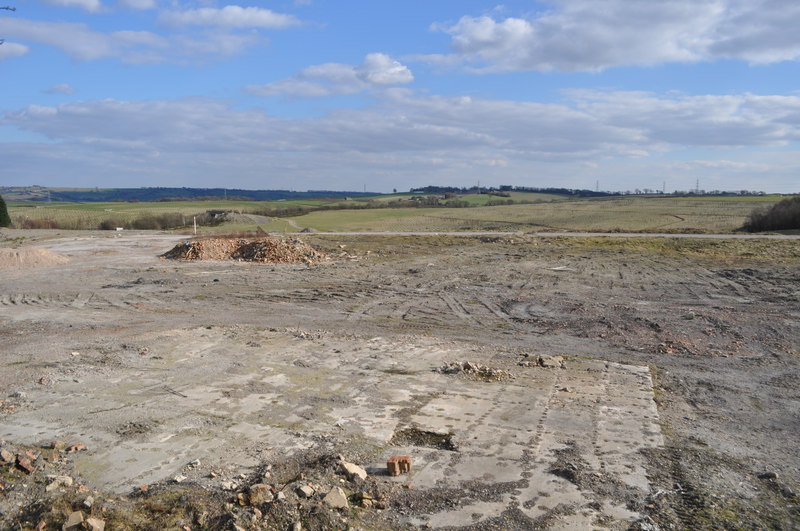
Opencast away and landscaped. The colliery site, its tips and the old village south of the A632 were worked by opencast from November 1993, backfilled and restored; the Derbyshire HER holds a 1991 archaeological appraisal of the reclamation site. New Arkwright Town stands north of the road, a nature walk follows the old railway lines, and a monument to the colliery workforce was unveiled for the thirtieth anniversary of the move.
None; the site was opencast and landscaped in the 1990s.
Redevelopment
Opencast coal site 1993-c.2005, then restored land and nature walk; the village rebuilt on a new site.
Related mines
- Markham Colliery — Both Staveley Company pits: Arkwright was opened in 1938 to work coal too remote for Markham, and an underground link into Markham's Second Piper workings was planned for 1988 but abandoned when Arkwright closed.
Nearby mines
- Markham Colliery — 1.2 miles (1.9 km) N
- Bonds Main Colliery — 1.6 miles (2.5 km) S
- Grassmoor Colliery — 1.9 miles (3.1 km) SW
- Bolsover Colliery — 2.0 miles (3.3 km) E
- Williamthorpe Colliery — 2.2 miles (3.5 km) S
Straight-line distance, within 9 miles (15 km). Show on the map.
Disasters & major incidents
-
Arkwright Town Methane Evacuation, 1988
9 November 1988 · Gas / Asphyxiation · 0 fatalities
Methane rising from the abandoned workings of Arkwright Colliery was found at explosive levels in the terraces of Arkwright Town six months after the pit closed; 110 people from 56 homes were evacuated for a fortnight, a pump was set in the old shaft, and British Coal eventually rebuilt the entire village on a new site and opencast the old one away.
Recorded claims
Individual factual claims, each attached to the source(s) that support it below. Where sources disagree, both are kept.
- The Arkwright drifts were sunk in 1938 into the Top Hard seam, near where the Brimington anticline brings it to the surface, by the Arkwright Colliery Company trading as S. E. Short and Company under the Staveley Company. 1,2
- A 21-foot shaft to the Deep Soft at 220 yards, begun in 1945 as Arkwright No. 2, was abandoned after ninety feet of brickwork and filled in 1952. 1
- The pit worked the Top Hard (exhausted 1953), Sitwell (from 1943-44), First and Second Waterloo, Second Ell and Low Main seams. 1
- Output rose to 625,000 tons by 1968 and 750,000 tons by 1975; a third drift with two surface fans was driven in 1972. 1
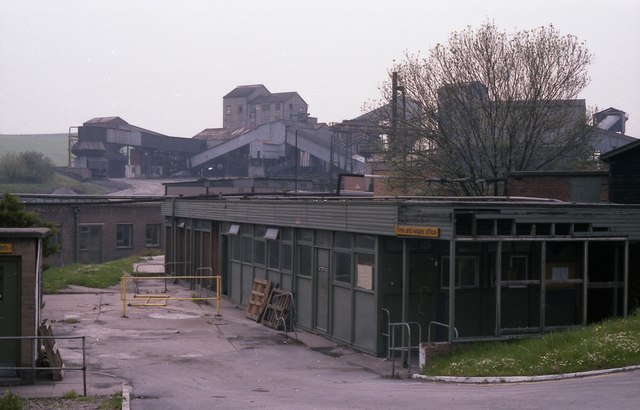
- The colliery closed in April 1988 with a planned link to Markham abandoned; Wikipedia gives 1988 and the wages office was photographed shortly after closure in May 1988. 1,3,4
- Derbyshire miners voted against the 1984-85 strike but joined after Yorkshire pickets came to Arkwright; the first returned to work in July 1984 and by February 1985 only four families in the village remained on strike. 3
- On 9 November 1988 a state of emergency was declared when methane escaping from underground workings was found in the village; 110 people from 56 homes were evacuated for two weeks. 2,5
- British Coal built a new village of 56 properties north of the A632 and moved all 400 residents; construction was complete by 1995, when old Arkwright Town was demolished, and a 100-acre opencast site was worked from November 1993 until about 2005. 5,3,6
- Arkwright Town was laid out by the Staveley Company from 1897, five rows totalling 160 houses, with a school for 422 children built in 1900. 2
- An archaeological appraisal of the Arkwright Colliery reclamation site was commissioned from the Creswell Heritage Trust in 1991 before development. 7
- The BGS mine-plans catalogue holds a Mining Remediation Authority abandonment plan titled 'Arkwright' (catalogue EMST36, Spoil Tip (Ref Nos. 11/003 And 11/116), dated 1988). 8
Photographs & further reading
Brian Spray's photographs of the old village before demolition and the Independent's 1994 account of the methane and the move.
View sourceAndrew Bridgewater's detailed history of the drifts, seams, the abandoned 1945 shaft and closure, with mining plans.
View sourceSources
- (secondary) Arkwright Colliery, 1938-1988 (oldminer.co.uk) — oldminer.co.uk (Andrew Bridgewater)
- (secondary) Arkwright Town, 1897-1995 (oldminer.co.uk) — oldminer.co.uk (Andrew Bridgewater)
- (secondary) Arkwright Town (Wikipedia) — Wikipedia
- (observational) Arkwright colliery wages office, shortly after closure (Geograph photograph, May 1988) — Geograph / Dave Bevis
- (secondary) Why will the village cross the road? (Simon Beckett, The Independent on Sunday, 17 April 1994; transcribed on oldminer.co.uk) — The Independent on Sunday
- (secondary) Arkwright Town (Wikishire) — Wikishire
- (primary) Derbyshire HER source SDR22461: Arkwright Colliery reclamation site, archaeological appraisal (Creswell Heritage Trust, 1991) — Derbyshire Historic Environment Record
- (primary) BGS / Mining Remediation Authority mine plans: ARKWRIGHT — British Geological Survey / Mining Remediation Authority
- (observational) Site of Arkwright Town Colliery (Geograph photograph, 19 March 2011) — Geograph / Ashley Dace
Record created: 9 September 2026 · Last researched: 9 September 2026