 MineArchive
Anticlines and Synclines
| Also known as | Folds, Folding |
|---|---|
| Category | Structural Controls |
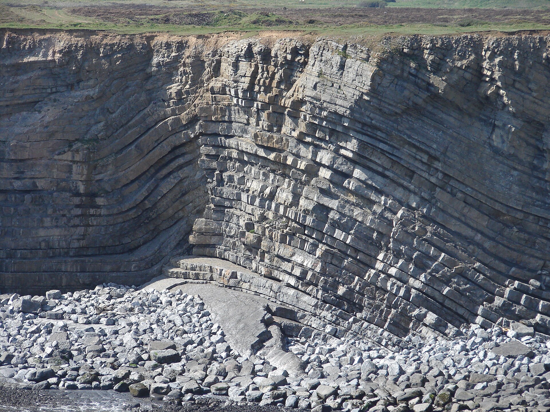
Folds are bends in layered rock. An anticline is an arch, with the oldest beds in its core; a syncline is a trough, with the youngest beds in its core. Folding creates no mineral, but it decides where a seam or bed lies shallow, where it lies deep, how steeply it dips and whether it has survived erosion at all, and it gives a coalfield its shape.
How it forms
Folds form mostly where layers of rock are shortened, and a set of folds on a regional scale makes a fold belt, a normal feature of mountain-building zones. Each fold has two limbs that meet at a hinge. Folds range from gentle, where the limbs lie at more than 120 degrees to each other, through open and close to tight, where the angle is under 30 degrees, and many are asymmetrical, with one limb steeper than the other. The Coal Measures of South Wales were folded in the Hercynian mountain-building at the end of the Carboniferous, and the syncline of the South Wales coalfield is the outstanding structure of that age: it runs from St Bride's Bay in Pembrokeshire through Carmarthenshire and Glamorgan into Monmouthshire.
Why minerals concentrate here
A fold preserves and exposes. In the trough of a syncline the younger beds are carried down out of reach of erosion, which is why a coalfield is so often a basin: the Coal Measures survive in the downfold and have been stripped from the arches on either side. South of the South Wales coalfield the synclines are deep enough to keep the Namurian beds that lie just below the Coal Measures, but not the Coal Measures themselves, and within the coalfield the very highest measures survive only as outliers in its minor synclines. An anticline does the opposite and brings older beds up: the lowest Coal Measures shales come to the surface in the core of the Maesteg anticline. An arch can also hold what rises into it. Oil and natural gas were obtained by boring on the crest of the D'Arcy–Cousland Anticline in Midlothian.
Typical shape of the deposit
Folds come at every scale and are seldom tidy. The South Wales syncline is not one trough but a string of elongated basins and domes arranged en echelon, each dying out along its length, with a central arch, the Pontypridd anticline, dividing the eastern part into two lesser synclines. Smaller folds are commonest in the weaker shales of the Lower and Middle Coal Measures. Dips vary accordingly. Along parts of the north crop of South Wales they are little more than five degrees. The Midlothian syncline is asymmetrical, with gentle dips on its eastern side, a flatter centre and very steep dips on the west.
What this means for mining
Where a pit sits on a fold decides how it must be worked. On the steep western limb of the Midlothian syncline the coals were known as edge coals, and the group of rocks that holds them was first named the Edge Coal Group; in North Staffordshire seams that climb steeply back to the surface were rearers, and at Apedale the seams lay at about forty degrees. In the trough the seams flatten but lie deep: Bilston Glen's shafts were placed to meet the Midlothian seams where they level out. An anticline brings coal within reach, as the Brimington anticline does for the Top Hard at Arkwright, which was worked by drifts. Sharp folding can lose a seam altogether, as at Eastern United in the Forest of Dean, where the seams were recovered only by long cross dipples, and tightly folded fields such as Somerset were awkward and expensive throughout. Folds matter to metal mines too: at Dolaucothi the gold lies in quartz veins along the Cothi Anticline, the richest of them a saddle reef.
Associated commodities
Coal (Coalfields are preserved in synclines, and the fold sets the dip of every seam.)
Related geology
Concealed Coalfields, Faults and Fractures, Sedimentary Beds and Seams, Strike and Dip
Images
MineArchive examples
Included only where MineArchive's own research gives a reasonable evidential basis — not every mine where this geology might plausibly apply. Showing the 10 strongest examples of 17 linked mines.
- Eastern United Colliery — Forest of Dean (well documented example)
Monoclinal folding lost the seams in the main headings, and they were recovered only by driving long cross dipples. - Arkwright Colliery — Derbyshire (well documented example)
Drifts were driven into the Top Hard near where the Brimington anticline brings it close to the surface. - Bilston Glen Colliery — Midlothian (well documented example)
The shafts were placed to meet the seams where they flatten out in the trough of the Midlothian syncline, below the steep dips of its flanks. - Dolaucothi Gold Mines — Carmarthenshire (well documented example)
Gold occurs in quartz veins along the Cothi Anticline; the richest deposit was the 'Roman Lode' saddle reef. - Foxyards Colliery — West Midlands (well documented example)
The Dudley and Sedgley anticline throws the measures up steeply; beside the Wren's Nest the Thick Coal is nearly vertical. - Pensford Colliery — Somerset (well documented example)
Sunk in 1909 to work the deeper seams of the Pensford syncline. - Burrow Farm Mine — Somerset (historical documentary reference)
The lodes lie in Morte Slates folded into the Brendon anticline and syncline. - Longannet Colliery — Fife (historical documentary reference)
The seams occupy the Leven Syncline, which extends south beneath the Firth of Forth. - Minnie Pit — Staffordshire (historical documentary reference)
An old shaft at Miles Green was sunk into the Bullhurst rearers, where the seam climbs steeply back to the surface. - Apedale Colliery — Staffordshire (historical documentary reference)
The seams lay at around forty degrees in the folded North Staffordshire coalfield.
See all 17 linked mines.
Sources
- (primary) British Regional Geology: South Wales — British Geological Survey
- (primary) The Geology of the Midlothian Coalfield — British Geological Survey
- (secondary) Anticline — Wikipedia
- (secondary) Fold (geology) — Wikipedia
Record created: 1 October 2026 · Last researched: 1 October 2026