 MineArchive
Faults and Fractures
| Category | Structural Controls |
|---|
A break in rock along which the two sides have moved relative to each other (a fault) or simply cracked without necessarily moving (a fracture or joint) — not itself a source of valuable material, but one of the most important controls on where mineral deposits form, and, separately, a hazard capable of displacing or destroying an orebody miners were actively working.
How it forms
Faults and fractures form wherever rock is put under enough stress — from tectonic plate movement, the weight of overlying rock, or the cooling and contraction of igneous rock — to break rather than simply bend. Once formed, a fault or fracture creates a genuine weakness and, often, an open pathway through otherwise solid rock, one that can persist and be reactivated repeatedly over geological time.
Why minerals concentrate here
Faults and fractures matter to mineralisation in two distinct ways. First: they provide the open pathway a hydrothermal fluid needs to move through the crust at all, and a fracture with the right orientation and enough repeated movement can channel a very large volume of metal-bearing fluid through one relatively narrow zone over time, concentrating dissolved metal that would otherwise have been spread through an enormous volume of rock — see Hydrothermal Deposits. Second, faults can act after a deposit has already formed, displacing an existing vein or bed — sometimes by centimetres, sometimes by kilometres — and cutting it off from view, forcing miners to relocate the missing section before they could carry on working it.
Typical shape of the deposit
Faults and fractures are themselves planar or near-planar features — essentially cracks — rather than deposits with a shape of their own; what matters for mining is the mineral body that may fill them (see Veins and Lodes) or the offset they've imposed on a deposit formed some other way.
What this means for mining
Where a fault or fracture hosts mineralisation, it directly dictates a vein's orientation and course, exactly as described under Veins and Lodes. Where a fault instead displaces an already-formed deposit, it creates a genuine and sometimes very costly problem: at Alderley Edge, a major fault struck around 1862 cut the mineralised ground the mine had been working, and further exploratory levels had to be driven specifically to relocate it on the other side. Recognising and correctly reading fault displacement — working out which way and how far a cut-off vein has moved — was a genuinely difficult, high-stakes piece of underground geology, since guessing wrong meant driving expensive development work in entirely the wrong direction.
Related geology
Anticlines and Synclines, Dykes and Sills, Hydrothermal Deposits, Iron Replacement Deposits, Veins and Lodes
Related Mining Terms & Methods
Crosscut (Sometimes driven specifically to relocate a fault-displaced vein.), Lode (The Cornish/Devon term for the same feature.), Mine Tremors (Mining-induced tremors are generated by movement along fracture planes as ground settles into a mined-out void — fault reactivation in miniature.), Vein (A fault or fracture is what a vein fills.)
Diagrams
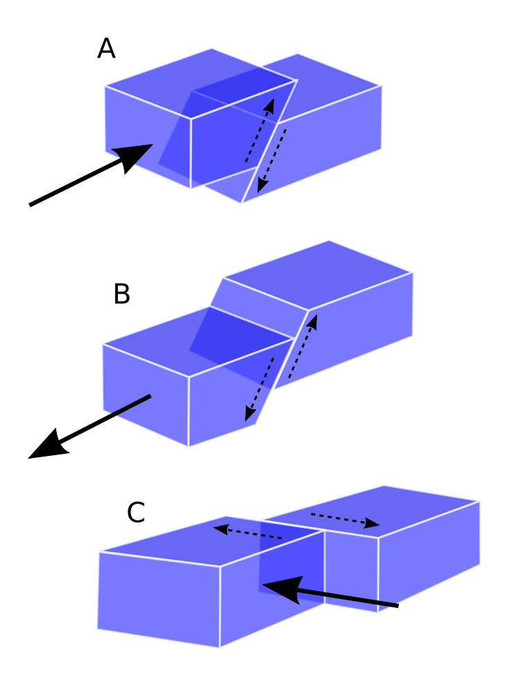
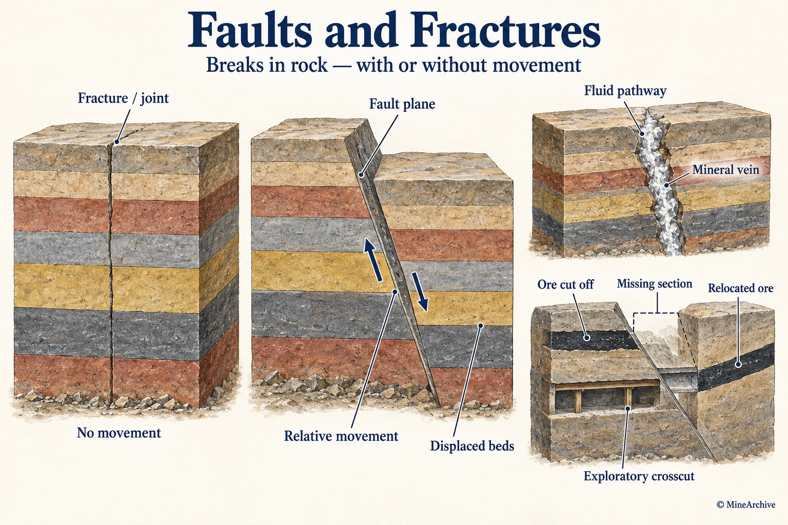
MineArchive examples
Included only where MineArchive's own research gives a reasonable evidential basis — not every mine where this geology might plausibly apply. Showing the 10 strongest examples of 51 linked mines.
- Ladysmith Pit — Cumbria (notable incident)
Two faults cut the ground where the shaft side collapsed during sinking in 1901, one crossing the shaft at about 60 degrees. - Auchenharvie Colliery — North Ayrshire (well documented example)
The Capon Craig Gaw, a whin dyke, was the colliery's eastern boundary and its safeguard — a wall of igneous rock holding back flooded workings, which both leases forbade anyone to cut. - Eastern United Colliery — Forest of Dean (well documented example)
Monoclinal folding of the strata was the colliery's defining problem: it lost the seams in the main headings, and in 1914 made the western portion of the gale unworkable altogether. - Minnie Pit — Staffordshire (well documented example)
The Seven Feet was undulating and cut by many faults, which forced pillar and stall working in one section. - Peak Alum Works — North Yorkshire (well documented example)
The Peak Fault is the reason the works stands here: the fracture brought the alum-bearing shale to the surface, where it could be quarried from the hillside rather than mined. - Torr Works — Somerset (well documented example)
The quarry cuts the southern flank of the Beacon Hill Pericline, the fold whose opposite flank is worked by Whatley Quarry. - Whatley Quarry — Somerset (well documented example)
The quarry cuts one flank of the Beacon Hill Pericline, a fold structure, and the BGS account records that minor faulting within the worked ground is significant. - Aberbeeg Colliery — Blaenau Gwent (well documented example)
The Llanhilleth fault dropped the Brithdir seam about ninety metres at Aberbeeg and thinned its section, which is the reason this pit was sunk rather than the seam being taken from levels as it was to the north. - Alderley Edge Mines — Cheshire (well documented example)
Exploratory levels were driven to relocate mineralised ground after a major fault was struck around 1862. - Alum Bay Sand and Copperas Workings — Isle of Wight (well documented example)
Alpine folding turned the Palaeocene and Eocene beds on end, which is why a long stratigraphic sequence is readable across a few hundred metres of cliff — and why the bay looks the way it does.
See all 51 linked mines.
Sources
- (secondary) Faults and Fractures: Key Influencers in Ore Formation — Christophe Garon
- (secondary) Structural Controls on Gold Deposits: A Geologist's Guide — Discovery Alert
Record created: 22 August 2026 · Last researched: 22 August 2026