 MineArchive
Dykes and Sills
| Also known as | Igneous Intrusions, Whin Dykes (northern coalfields) |
|---|---|
| Category | Structural Controls |
A dyke is a sheet of igneous rock that cuts across older beds; a sill is a sheet forced in between them, parallel to the bedding. Both began as molten rock that filled a crack and froze there. Neither is an ore deposit. To a miner they are a wall or a floor of hard rock set through softer ground: they burn and cut off coal seams, they make good walls for mineral veins, and where they reach the surface they are a stone worth quarrying for its own sake.
How it forms
Magma rising through the crust fills a fracture and solidifies as a sheet. Where the sheet cuts across the layering it is a dyke, usually steep, with roughly parallel walls and a thickness that is small beside its length; swarms of dykes form where the crust is being pulled apart. Where the magma spreads sideways between beds it makes a sill, and sills are fed by dykes. A large sill does not keep to one level: it steps up and down through the sequence, and many have an overall saucer shape. In northern England the Whin Sill and its dykes were intruded in the earliest Permian, about 297 million years ago, and the sill-swarm underlies some 4,500 square kilometres. The word itself comes from there: northern quarrymen called a flat-lying body of rock a 'sill' and any hard dark rock 'whin', and geologists adopted 'sill' once the Whin Sill was recognised as an intrusion.
Why minerals concentrate here
An intrusion matters to mining through its heat, its strength and its own substance. Heat first: the rank of coal rises sharply towards an intrusion until, at the contact, the coal has become a natural coke, the cindered coal of the Durham pits. Beside the Brandon Dyke in the Hutton seam there were 45 feet of cindered coal and a further 210 feet of 'bad' coal beyond it, and the Ludworth Dyke is flanked near Easington and Horden by belts of low-volatile coal three-quarters of a mile wide. Strength second: in the North Pennines the mineral veins cut the Whin Sill and its dykes, and the dolerite, like limestone and massive sandstone, is a competent wall rock and a favourable host for ore. And the rock itself: dolerite, the quarryman's whinstone, has a high polished stone value, which makes it ideal as roadstone.
Typical shape of the deposit
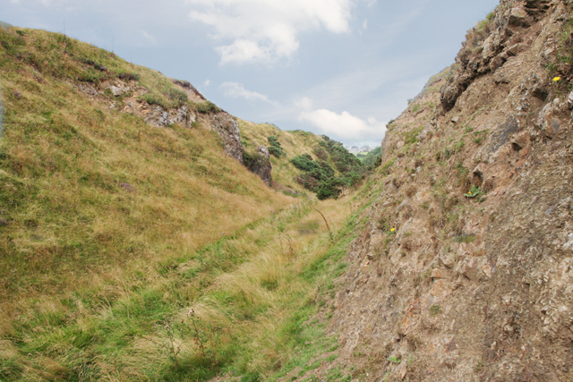
A dyke is a near-vertical wall. Most are from about a metre to a few tens of metres thick and can run for tens of kilometres, often as a line of short overlapping segments. The dykes that go with the Whin Sill are typically 3 to 10 metres wide; the Hett Dyke of the Durham coalfield is 10 to 12 feet across, while the Ludworth Dyke measures between 32 and 90 feet where workings have crossed it. They hold their line with depth: the Hett Dyke in the Brockwell seam lies almost directly beneath its outcrop some 700 feet above. A sill is a sheet. The Great Whin Sill averages about 30 metres thick and reaches 81 metres in a boring in West Allendale, while sills only a foot or two thick lie within the Busty seam beside the Ludworth Dyke.
What this means for mining
In a coalfield a dyke is a boundary. The coal beside it is spoiled, the dyke itself is hard dolerite, and workings commonly stop against it: the Ludworth Dyke forms the southern limit of the Sherburn Hill workings, and where neighbouring collieries were joined, as Shotton and Haswell were through 63 feet of it, the connection was a deliberate drivage through the stone. Blenkinsopp Colliery in Northumberland closed in 2002 with a whin dyke standing between it and eight million tons of reserves. In an orefield the same rock is welcome, because it is a favourable host for veins. At the surface the intrusion becomes the product. The Hett Dyke was quarried along its outcrop and worked from six shafts at Hett; the Cleveland Dyke was taken for roadstone at Cockfield Fell and Bolam; and the Whin Sill has long been quarried at many places, with large quarries at Barrasford, Swinburne, Divethill, Longhoughton and Belford in Northumberland and near High Force in Teesdale.
Associated commodities
Coal (Seams are cut off by dykes and the coal beside them is cindered.), Whinstone (The dolerite of dykes and sills, quarried as whinstone.)
Related geology
Coal Formation and Rank, Concealed Coalfields, Faults and Fractures, Sedimentary Beds and Seams, Veins and Lodes
Related Mining Terms & Methods
Roadstone (The main product of the quarries on the Whin Sill and the Cleveland Dyke.), Whinstone (The quarryman's name for the dolerite and basalt of dykes and sills.)
Images
MineArchive examples
Included only where MineArchive's own research gives a reasonable evidential basis — not every mine where this geology might plausibly apply. Showing the 10 strongest examples of 15 linked mines.
- Auchenharvie Colliery — North Ayrshire (notable incident)
A heading driven through the Capon Craig Gaw, a whin dyke through the coal measures, let in the water that drowned nine people in 1895. - Barrasford Quarry — Northumberland (surviving physical example)
A working whinstone quarry on the Whin Sill in the North Tyne valley. - Divethill Quarry — Northumberland (surviving physical example)
A working whinstone quarry on the Great Whin Sill in Northumberland. - Force Garth Quarry — County Durham (surviving physical example)
Works the Great Whin Sill in Upper Teesdale for roadstone. - Egton Quarry — North Yorkshire (well documented example)
Quarried the Cleveland Dyke where it crosses the Esk valley near Grosmont. - Fairykirk Quarry — Fife (well documented example)
Quarried the quartz-dolerite of the Midland Valley Sill-complex. - Tudhoe Whinstone Mine — County Durham (well documented example)
Worked the Hett Dyke itself, first in an open trench along the outcrop and by 1882 underground from shafts. - Coronation Pit, Walbottle — Tyne and Wear (historical documentary reference)
Two basalt or whin dykes cross the Walbottle royalty. - Minto Pit — Fife (historical documentary reference)
An intrusive whinstone sill 32 fathoms thick lay above the Five Foot coal. - Roachburn Colliery — Cumbria (historical documentary reference)
A whin dyke eleven yards thick crossed the workings between Roachburn and Byron.
See all 15 linked mines.
Sources
- (primary) Early Permian magmatism, Northern England — British Geological Survey (Earthwise)
- (primary) Industrial minerals, geology and man, Northern England (British regional geology: Northern England, 5th edition, 2010) — British Geological Survey
- (primary) Smith, D. B. and Francis, E. A. (1967). Geology of the country between Durham and West Hartlepool (Memoir for Sheet 27), Chapter 4: Intrusive igneous rocks - the Hett Dyke — British Geological Survey
- (secondary) Dike (geology) — Wikipedia
- (secondary) Sill (geology) — Wikipedia
- (secondary) Whin Sill — Wikipedia
Record created: 1 October 2026 · Last researched: 1 October 2026