 MineArchive
Fairykirk Quarry
| Also known as | Fairy Kirk Quarry |
|---|---|
| Location | Fairykirk, Inverkeithing, Fife — 56.0240, -3.3950 (approximate, low confidence) |
| Commodity | Whinstone |
| Type | Quarry |
| Worked | from Working by the mid-19th century |
| Maximum depth | Unknown. |
Overview
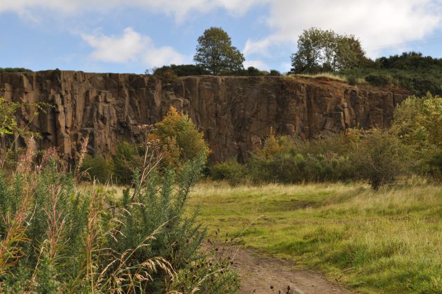
Fairykirk Quarry is a small disused opencast stone quarry at Fairykirk, a wooded hill above Inverkeithing in Fife. The name is older than the quarry: Fairykirk first appears on an Ordnance Survey map of 1856, and the OS Name Book explains it as a small cliff on the top of a steep brow, supposed by some to be a resort of fairies. The quarry is one of the five separate locations that make up the Ferry Hills Site of Special Scientific Interest, and its faces are now used by rock climbers.
History
Fairykirk is first documented on an Ordnance Survey map of 1856. According to the OS Name Book the name refers to a small cliff on the top of a steep brow, supposed by some to be a resort of fairies; Fairy Kirk road in neighbouring Rosyth takes its name from it in turn. A small opencast stone quarry, Fairykirk quarry, once operated there.
That is very nearly the whole of the industrial record. Nothing on record names an owner, a date of opening or closing, a workforce or an output — the quarry survives in the record chiefly because of what was left behind rather than what came out. On 22 February 1992, 1.72 hectares of Fairykirk was designated as part of the Ferry Hills Site of Special Scientific Interest. NatureScot's management statement describes the SSSI as made up of five separate locations in the North Queensferry area — extensive road cuttings, a railway cutting, a small disused quarry to the north, which is this one, and a grassland hilltop to the south. The site is notified for two features, lowland calcareous grassland and Carboniferous-Permian igneous geology, both of which were found to be in unfavourable and declining condition when monitored in June 2006; the igneous feature was judged so partly because the rock faces were being obscured by metal netting and vegetation.
Geology
The Ferry Hills SSSI is notified for its Carboniferous-Permian igneous geology, and the interest is the Midland Valley Sill-complex of Late Carboniferous age — a body of intruded quartz-dolerite, the hard rock that Scotland calls whinstone and quarried wherever it broke surface, for roadstone and setts. NatureScot's statement notes that the extensive road cuttings along the A90 north of the Forth Road Bridge provide by far the best and most comprehensive fresh exposures of that sill complex. It should be said plainly that no source states outright what rock the face of Fairykirk quarry itself is cut in. What is documented is that the quarry is one of the five locations of an SSSI whose geological feature is the sill complex, and that its faces are sound enough to be climbed; the identification as whinstone follows from that rather than from a direct statement, and is recorded here with that qualification.
Geological setting: Dykes and Sills (well documented example), Faults and Fractures (historical documentary reference)
Workings
A small opencast stone quarry on the hill at Fairykirk, north of the main Ferry Hills ground. Its notified area is 1.72 hectares. Nothing on record describes its plant, its method of working or how the stone was taken away.
Closure
The closure date is not known. The quarry was disused well before the 1992 designation and nothing on record narrows it further.
What remains
Disused, wooded and climbed. Fairykirk is now scrubland and wooded hilltops, and according to Fife Council it is a popular area with walkers, dog walkers, mountain bikers and climbers; NatureScot records that Fairy Kirk Quarry is popular with rock climbers and features in the local Scottish Mountaineering Club guide. Nature is reclaiming the workings, and that is a designation problem as well as a picturesque one: the igneous feature was assessed as unfavourable and declining in June 2006 partly because vegetation and metal netting were obscuring the rock faces.
The quarry faces themselves, partly obscured by vegetation and by metal netting, within woodland and scrub. Nothing on record describes a surviving quarry structure.
Nearby mines
- Prestonhill Quarry — 0.4 miles (0.7 km) NE
- Dalmeny No. 2 and 3 Pits — 3.2 miles (5.1 km) S, West Lothian
- Duddingston No. 1 and 2 Mines — 3.4 miles (5.5 km) SW, West Lothian
- Charlestown Limeworks — 4.1 miles (6.7 km) W
- Halbeath Colliery — 4.4 miles (7.0 km) N
Straight-line distance, within 9 miles (15 km). Show on the map.
Recorded claims
Individual factual claims, each attached to the source(s) that support it below. Where sources disagree, both are kept.
- Fairykirk is first documented on an 1856 Ordnance Survey map, and according to the OS Name Book the name refers to a small cliff on the top of a steep brow, supposed by some to be a resort of fairies; Fairy Kirk road in neighbouring Rosyth takes its name from Fairykirk. 1
- A small open cast stone quarry, Fairykirk quarry, once operated at Fairykirk. 1
- On 22 February 1992, 1.72 hectares of Fairykirk was designated as part of the Ferry Hills Site of Special Scientific Interest. 1
- Ferry Hills SSSI is made up of five separate locations in the North Queensferry area — extensive road cuttings, a railway cutting, a small disused quarry to the north (Fairy Kirk Quarry) and a grassland hilltop to the south — and is notified for lowland calcareous grassland and Carboniferous-Permian igneous features; the road cuttings along the A90 north of the Forth Road Bridge provide by far the best and most comprehensive fresh exposures of the Late Carboniferous age Midland Valley Sill-complex. 2
- Site condition monitoring in June 2006 found the Carboniferous-Permian igneous feature to be in unfavourable declining condition due to some obscuring of the rock faces by metal netting and vegetation. 2
- Fairy Kirk Quarry is popular with rock climbers and features in the local Scottish Mountaineering Club guide. 2,3
Photographs & further reading
NatureScot's own statement for the designated site, which places this quarry as one of the SSSI's five locations, identifies the geological interest as the Midland Valley Sill-complex, and records the condition of the rock faces.
View sourceSources
- (secondary) Fairykirk — Wikipedia
- (primary) Ferry Hills Site of Special Scientific Interest: Site Management Statement — NatureScot
- (observational) Fairykirk Quarry, Inverkeithing (photograph) — Geograph Britain and Ireland
Record created: 4 September 2026 · Last researched: 5 September 2026