 MineArchive
Charlestown Limeworks
| Also known as | Charlestown Limekilns |
|---|---|
| Location | Charlestown, on the Forth shore west of Limekilns, Fife — 56.0367, -3.5000 (approximate) |
| Commodity | Limestone |
| Type | Quarry |
| Worked | 1756–1956 |
| Maximum depth | Surface quarrying and kiln working; no depth figure applies. Canmore records an associated limestone mine as well as the quarry. |
| Operators | Earl of Elgin (1756–?) |
Overview
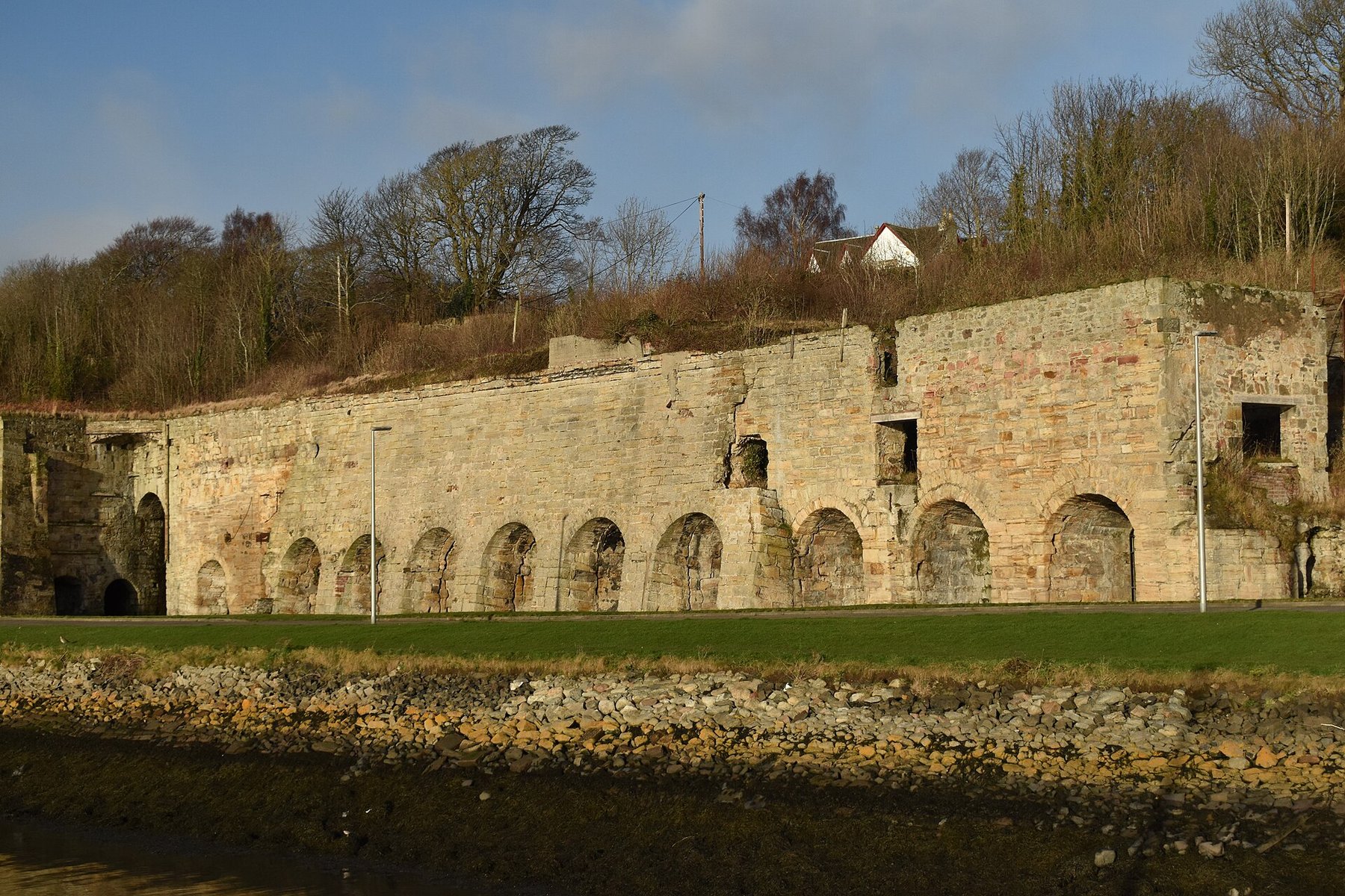
The limestone quarries and kilns built on the Forth shore by Charles Bruce, 5th Earl of Elgin, from 1756 — the largest group of limekilns in Scotland, a range of fourteen in dressed stone, said to have produced a third of all Scottish lime. The Earl laid out a planned village to work them, its streets arranged as a C and an E for his own name, and a harbour so that ships could load as close to the kilns as possible.
History
Charlestown was founded in 1756 by Charles Bruce, 5th Earl of Elgin, as a harbour town for shipping coal from his Fife estates and for making lime. It was the first model village in Scotland, predating New Lanark, and its Georgian terraces are laid out in the shape of the letters C and E.
The kilns followed. Building began around 1761, and the first nine of the surviving range were raised in 1777–78 with five more added in 1792; the majority were built between 1761 and 1799, with further kilns added in the nineteenth century. They were served by Charlestown harbour and by the Elgin Railway, a horse tramway, and later by a North British Railway branch since lifted. The harbour's outer basin was built around 1840.
Through the late eighteenth and nineteenth centuries the kilns formed part of a major industrial complex that also took in coal mining, ironworking and salt extraction, with coal and limestone brought in from the Earl's own quarries. The lime went to agriculture for soil improvement and to building work for mortar and plaster.
The works ran down from the 1930s. Most of the complex closed in 1935, and lime production finished in the mid-1950s. In the twentieth century a limestone-crushing plant was installed within the four easternmost kilns; excavation has since found its concrete plinths and the decayed timber sleepers of the light railways that carried the processed lime away.
Geology
The works drew on the Carboniferous limestones of west Fife, quarried on the Earl of Elgin's own ground immediately behind and above the kilns — Canmore records a West Quarry limestone quarry and mine as part of the same complex. Burning that limestone drove off carbon dioxide to leave quicklime, the product the whole enterprise existed to make and ship.
Geological setting: Sedimentary Beds and Seams (well documented example)
Workings
Quarries above and behind the kiln range, with the kilns themselves cut into the face of the slope so that limestone and fuel could be barrowed in at the top and burnt lime drawn out at the bottom, straight down to the harbour. The range is fourteen kilns long, of some complexity, all in dressed stone. Charlestown harbour was built so that vessels could get as close to the kilns as possible; the Elgin Railway, a horse tramway, and later a North British Railway branch served the site, and light railways ran along the kiln fronts to take the processed lime away.
Closure
Sources differ on the ending. Most of the works closed in 1935 as the operation ran down from the 1930s; Wikipedia gives final closure in 1956, while Canmore's excavation report refers to the limeworks being abandoned in 1957 and one account gives the kilns and quarry as in use until 1935. The most consistent reading is that the bulk of the complex went in 1935 and lime burning finally ceased in the mid-1950s.
What remains
The kilns survive as massive remains on the north side of East Harbour Road, a Scheduled Monument and Category A listed. The site has been consolidated and opened to visitors: Kiln 11 has been excavated and displayed, an interpretation centre built at the eastern kilnhead, and the Scottish Lime Centre Trust runs workshops from the Charlestown site. Almost all the ancillary buildings around the kilns have gone. The planned village survives with its houses B listed within a conservation area, and the site remains in the ownership of the Broomhall Estate.
The fourteen-kiln range in dressed stone, the harbour built to serve it, the line of the Elgin Railway, and the excavated remains of the twentieth-century crushing plant set within the four easternmost kilns.
Redevelopment
Consolidated and interpreted as industrial heritage: an interpretation centre at the east kilnhead, Kiln 11 excavated and displayed, and the Scottish Lime Centre Trust's workshops on the site.
Nearby mines
- Isle of Canty Colliery — 3.1 miles (5.0 km) N
- Bridgeness Colliery — 3.3 miles (5.4 km) SW, Falkirk
- Rosebank Colliery, Dunfermline — 3.6 miles (5.8 km) N
- Elgin and Wellwood Colliery — 3.8 miles (6.1 km) N
- Carriden Colliery — 3.9 miles (6.2 km) W, Falkirk
Straight-line distance, within 9 miles (15 km). Show on the map.
What's uncertain
Points where sources disagree or the record could not be settled; both accounts are kept. All open questions in the archive.
- Sources disagree on the end of the works: most of the complex closed in 1935 as the operation ran down from the 1930s, Wikipedia gives final closure in 1956, and Canmore's excavation report refers to the limeworks having been abandoned in 1957. (disputed) 2,1
Recorded claims
Individual factual claims, each attached to the source(s) that support it below. Where sources disagree, both are kept.
- Charlestown was established in 1756 by Charles Bruce, 5th Earl of Elgin, as a harbour town for shipping coal from his Fife estates and for lime production; it was the first model village in Scotland, laid out in the shape of the letters C and E. 1
- The range is fourteen kilns long, of some complexity, all built of dressed stone, and is the largest group of limekilns in Scotland. 2,3
- Kilns were built from about 1761; the first nine of the range date from 1777–78 and a further five from 1792, the majority being built between 1761 and 1799. 2,3
- The kilns are said to have produced a third of all lime production in Scotland, supplying agriculture for soil improvement and building work for mortar and plaster. 3
- The kilns were served by Charlestown harbour, built so that ships could load as close to them as possible, by the Elgin Railway horse tramway and later by a North British Railway branch since lifted; the harbour's outer basin was added around 1840. 2,1
- Sources disagree on the end of the works: most of the complex closed in 1935 as the operation ran down from the 1930s, Wikipedia gives final closure in 1956, and Canmore's excavation report refers to the limeworks having been abandoned in 1957. (disputed) 2,1
- A limestone-crushing plant was installed in the twentieth century within the four easternmost kilns; excavation has recovered its concrete plinths and the decayed timber sleepers of the light railways that carried the processed lime away. 2
- The site is a Scheduled Monument and the kilns are Category A listed. 3
Photographs & further reading
The national record for the kiln range, gathering the descriptive accounts and the successive excavation reports that document what survives and what the twentieth-century crushing plant left behind.
View sourceAn account of the kilns' place in the industrialisation of the Forth, and of the conservation work done on them.
View sourceSources
- (secondary) Charlestown, Fife — Wikipedia
- (primary) Charlestown, Harbour Road, Limekilns (Canmore / NRHE 49497) — Historic Environment Scotland
- (primary) Charlestown, limekilns and associated features (Scheduled Monument) — Historic Environment Scotland
- (secondary) The Charlestown Limekilns — Inner Forth Landscape Initiative
Record created: 3 September 2026 · Last researched: 3 September 2026