 MineArchive
Strike and Dip
| Category | Structural Controls |
|---|
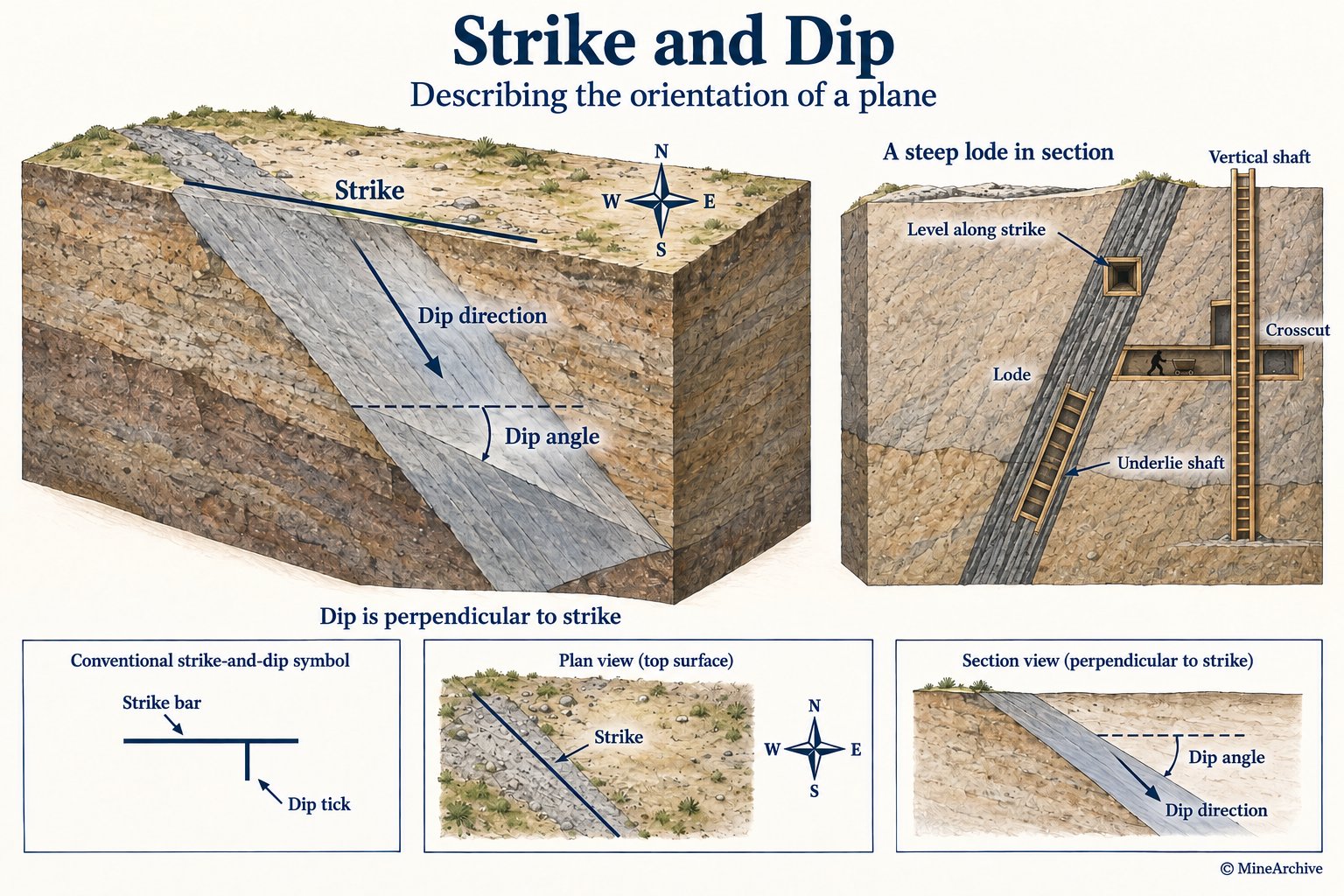
Strike is the compass bearing of the horizontal line formed where a tilted rock layer, mineral vein or fault plane intersects a horizontal surface; dip is the angle that same plane inclines downward away from the strike line, measured at right angles to it. Together the two figures describe, precisely and repeatably, which way a sloping geological feature runs and how steeply it descends.
How it forms
Strike and dip are not something that forms in their own right -- they are simply the geometry left behind by whatever tilted or fractured the rock. Sedimentary beds laid down flat can be folded and faulted by later tectonic movement, ending up dipping at an angle; mineral veins are even less likely to be perfectly vertical or horizontal to begin with, since they form by filling fractures whose orientation is controlled by the regional stresses acting on the rock at the time. Either way, once a layer or vein is anything other than flat, it has a definable strike and dip.
Why minerals concentrate here
Strike and dip do not themselves explain why ore concentrates -- that is a question about mineralisation, not orientation -- but they explain why economic deposits are so rarely worked as simple flat sheets. A vein fills a fracture that is inclined almost by definition, and a once-flat sedimentary seam is often tilted by the same tectonic activity that helped mineralise it in the first place. Knowing a deposit's strike and dip is what lets a mine follow it reliably, rather than rediscovering it by chance at every new working.
Typical shape of the deposit
Applies to planar or roughly planar bodies -- a vein or lode, a bedded seam, a fault plane -- rather than to a pipe, disseminated deposit or placer, none of which have a single strike and dip to measure.
What this means for mining
Once a lode's strike and dip are known, they directly shape how a mine is laid out. Levels are driven along the strike to stay within the ore as far as possible; crosscuts are driven across the strike, through barren ground, specifically to intersect a lode (or a fault) at a known point. Dip decides how a shaft reaches the ore: a shallow-dipping lode is usually reached by a vertical shaft with levels driven sideways to meet it, while a steeply dipping lode can instead be followed directly by an 'underlie shaft' sunk on an incline that matches the lode's own angle -- both approaches are recorded side by side in 19th-century Cornish mines. Traditional British mining practice measured dip not in degrees but as an 'underlie' expressed in feet per fathom of depth -- an 1856 survey recorded Dolcoath's main lode as running close to east-west and dipping 2 feet south in the fathom, and Condurrow's as running 5 degrees north of east and dipping 18 inches in the fathom -- the same strike-and-dip information geologists record today, in a distinctly Cornish form of words.
Related geology
Diagrams
MineArchive examples
Included only where MineArchive's own research gives a reasonable evidential basis — not every mine where this geology might plausibly apply. Showing the 10 strongest examples of 15 linked mines.
- Hyde Colliery — Greater Manchester (well documented example)
The inspector's report turns on the dip: the strata lie at about 28 degrees, roughly 1 in 1.88 to the north-west, which set the layout of the engine brow and the metal brow and meant the same seam lay at very different depths across the take. - Wheal Mary Ann — Cornwall (well documented example)
The mine's own recorded workings give a precise strike and underlie for the worked lode -- running 20-25 degrees west of south, with an average underlie east of about 15 inches per fathom -- the exact same Cornish strike-and-dip convention this article describes. - Arcow Quarry — North Yorkshire (well documented example)
The record describes beds of the Austwick Formation dipping steeply south on the north limb of the Studrigg-Studfold Syncline, truncated by an unconformity beneath the horizontal limestones of the Great Scar Limestone Group — the structure is what the quarry face exposes. - Arkwright Colliery — Derbyshire (well documented example)
The drifts were sited where the Brimington anticline's uplift brings the Top Hard seam close to the surface, so they could be driven in coal rather than rock. - Bog Mine — Shropshire (well documented example)
The mine's own recorded geology explicitly gives both strike and dip for the Bog Vein: running broadly east-west and dipping around 45 degrees to the south. - Brackley Colliery — Greater Manchester (well documented example)
The colliery's dip is recorded specifically as varying from 1 in 5.5 to 1 in 20 and averaging 1 in 14, markedly gentler than the rest of the coalfield, and is given as the reason it had relatively few geological problems. - Castletown Mine — Argyll and Bute (well documented example)
The mine's own recorded geology explicitly describes a north-east-trending vein dipping steeply west at 70 degrees. - Creggan Silver-Lead Mines — County Armagh (well documented example)
The mine's own recorded geology explicitly describes the worked lode's strike within the Longford-Down Inlier's Silurian rocks. - Greenside Mine — Cumbria (well documented example)
The mine's own recorded geology explicitly describes a north-south fault dipping steeply east, averaging 70 degrees but varying between 58 and higher, directly illustrating how a real vein's strike and dip were surveyed and worked. - Hafotty Manganese Mine — Gwynedd (well documented example)
The mine's own recorded geology explicitly describes a narrow manganese bed dipping steeply at roughly 70 degrees, a difficult geometry directly shaped by its dip.
See all 15 linked mines.
Sources
- (secondary) 1856 Mines in Devon and Cornwall — Grace's Guide
- (secondary) Strike and dip — Wikipedia
Record created: 1 September 2026 · Last researched: 1 September 2026