 MineArchive
Greenside Mine
| Also known as | Greenside Lead Mine |
|---|---|
| Location | Glenridding, Cumbria — 54.5480, -2.9840 (exact) |
| Commodities | Lead, Silver |
| Type | Metal |
| Worked | 1825–1962 |
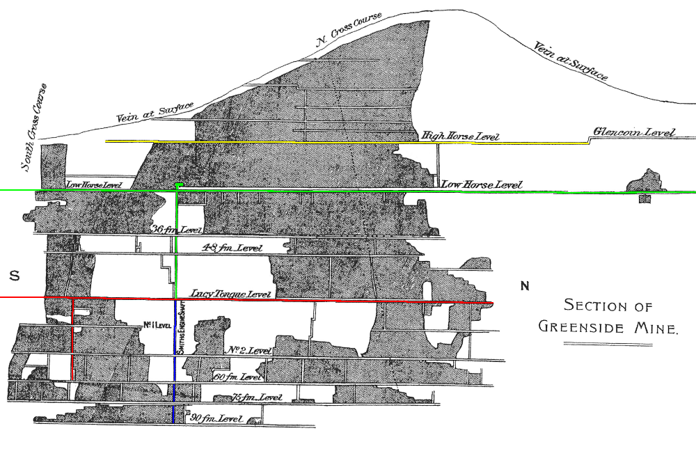
| Maximum depth | 237 fathoms (approx. 433 m) below Lucy Tongue Level |
| Operators | Greenside Mining Company (1825–1889), Greenside Mining Company Ltd (1889–1920), New Greenside Mining Company Ltd (1923–1935), Basinghall Mining Syndicate Ltd (1936–1954), Greenside Mines Ltd (1954–1962) |
Overview
Greenside was the largest lead mine in the Lake District and, during the Second World War, briefly the largest single producer of lead ore in the UK. Worked from 1825 to 1962 above the village of Glenridding, it drove an extensive network of levels under Helvellyn, Sheffield Pike and Glencoynedale, and in 1893 became the first metal mine in Britain to use electric underground haulage, powered by its own hydroelectric plant.
History
Lead-bearing veins on the fellside above Glenridding were almost certainly worked in a small way before formal record-keeping began — the earliest confirmed documentary reference is a legal brief from 1799, and claims of activity as early as 1690 have never been backed by documentary evidence. Organised mining began in 1825, when the newly formed Greenside Mining Company took over the site; after a difficult first decade, the arrival of the Kendal banker George Head Head as principal shareholder from 1835 put the company on a firmer footing.
Ownership changed hands repeatedly over the following century: the company was reconstituted as a limited company in 1889, refinanced in 1923, taken over by the Basinghall Mining Syndicate (a partnership of British Metal Corporation and Associated Lead Manufacturers) in 1936, and reorganised again as Greenside Mines Ltd in 1954. Output peaked during the Second World War, when the mine employed around 220 people and, in 1941, produced over 5,000 tons of lead — making it, briefly, the largest lead producer in the country.
By the late 1950s the workable ore was running out. A decision to wind down development work was taken in 1958, but closure was delayed when the Atomic Weapons Research Establishment used the deep workings for underground seismic trials — Operation Orpheus — extending the mine's life into 1962, by which point all recoverable ore had been drawn and the plant sold off.
Geology
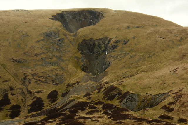
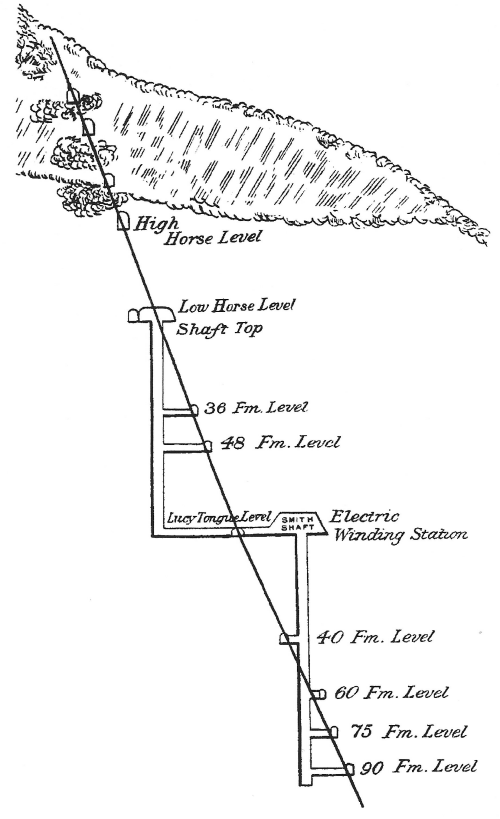
Greenside worked a single mineral vein filling a north-south fault running through the east ridge of the Green Side mountain, hosted in andesite of the Ordovician-age Borrowdale Volcanic Group, which itself rests on the older Skiddaw Group shales encountered in the mine's lowest levels, over 100m below sea level. The fault dips steeply east, averaging 70 degrees but varying between 58 degrees and vertical, and was traced for some 3,900 feet (1,200m) along its length and 2,900 feet (880m) in depth. Ore occurred in four discrete 'shoots' concentrated where the fault dip exceeded 70 degrees, ranging from 6 to 50 feet wide against barren sections of 5 to 7 feet; the ore itself was chiefly argentiferous galena (lead sulphide carrying a little silver), with baryte more common in upper workings and minor sphalerite and chalcopyrite appearing at depth, deposited by hydrothermal fluids at 110-130 degrees Celsius during the Carboniferous period, with the metal content likely sourced from the Skiddaw Group or a buried granite beneath it. Contemporary medical reports also noted that miners here suffered unusually high rates of pneumoconiosis (miners' phthisis), attributed at the time to silica dust thrown up by the quartzite and andesite host rock.
Geological setting: Faults and Fractures (well documented example), Hydrothermal Deposits (well documented example), Strike and Dip (well documented example)
Workings
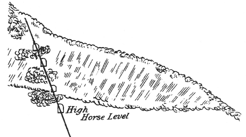
The mine was worked from a series of levels driven progressively deeper into the fellside, reaching a maximum depth of 237 fathoms (about 433 m) below Lucy Tongue Level by the mid-1950s. Underground haulage was originally by hand and horse, but in 1893 Greenside became the first metal mine in Britain to use electric underground locomotives and winding gear, powered by a hydroelectric station built near Red Tarn on the slopes of Helvellyn. The workings eventually extended for miles beneath Helvellyn, Sheffield Pike and Glencoynedale. An escape route created in 1954, running through the Alma workings, Low Horse Level, High Horse Level and Glencoyne Level, later became the route by which mine explorers re-entered the old workings.
Closure
Formal closure came in January 1962, once the Atomic Weapons Research Establishment's trials had finished and the last of the mine's equipment had been sold. Most of the surface plant was demolished shortly afterwards.
What remains
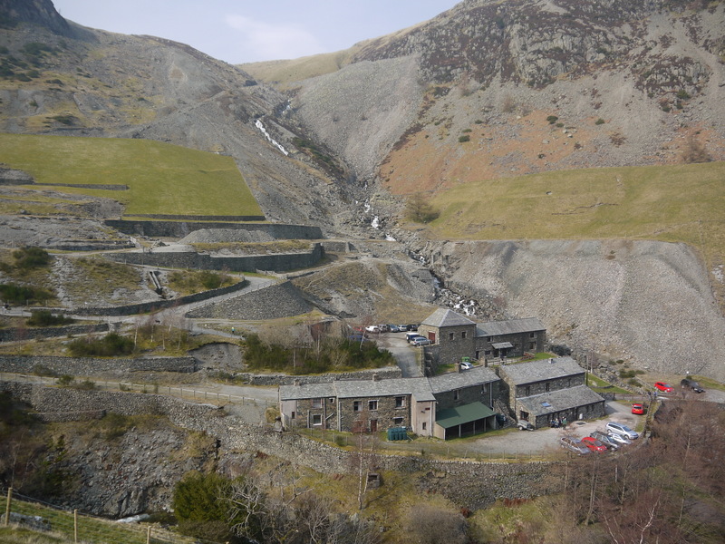
Little of the mine's industrial plant survives above ground; most buildings were demolished during the 1960s. Spoil heaps, collapsed adit entrances and the stanchion of a former aerial ropeway remain scattered across the fellside, and a blocked mine level is visible from the approach path. Mine explorers have used the 1954 escape route to reach parts of the underground workings since the late 1970s.
Two large spoil heaps survive close to the former mine buildings, one close enough to the youth hostel to have needed engineering attention. According to a 2009 site-visit report, the former workers' barracks now form the Helvellyn Youth Hostel, and the former mine office building is used as an Outward Bound centre.
Redevelopment
Following Storm Desmond in December 2015 and further heavy rainfall in the years after, concerns grew about runoff eroding the site's contaminated mine waste into Glenridding Beck. In 2016 the Lake District National Park Authority, the Coal Authority and the Environment Agency, working with an Army engineer regiment, relined roughly 200 m of the channel above the tailings dam. The lining was tested by exceptionally heavy rainfall in October 2021 and reportedly held without erosion.
Related mines
- Hartsop Hall Mine — The Greenside Mining Company, Greenside's operator, reopened Hartsop Hall in August 1888.
- Wheal Friendship — The same manager who made his name at Wheal Friendship went on to manage Greenside Mine, Magpie Mine and Coniston Copper Mines.
Nearby mines
- Eagle Crag Mine — 2.0 miles (3.3 km) S
- Wythburn Mine — 2.7 miles (4.4 km) SW
- Bramcrag Quarry — 3.9 miles (6.3 km) NW
- Hartsop Hall Mine — 3.9 miles (6.3 km) SE
- Myers Head Mine — 4.4 miles (7.0 km) SE
Straight-line distance, within 9 miles (15 km). Show on the map.
Disasters & major incidents
-
Keppel Cove dam burst, 1927
night of 28–29 October 1927 · Flooding / Inundation · 0 fatalities
After a night of exceptional rainfall and gale-force winds, the earth dam supplying Greenside Mine's hydro-electric power at Keppel Cove was overtopped and burst, sending a flood down into Glenridding village that wrecked shops, bridges and a hotel — four hotel staff were rescued from a flooding basement. -
Greenside Mine fire, 1952
7 July 1952 · Fire · 4 fatalities
A fire that broke out over a weekend in the North Shaft workings released carbon monoxide through the mine when the day shift restarted the air compressor, killing four miners — the worst single loss of life in Greenside's history. -
Greenside Mine gas exposure, 1960
14-15 January 1960 · Gas / Asphyxiation · 2 fatalities
Two surface workers at Greenside Mine, William Sinkinson and Alex Santamara, died from gas exposure after entering abandoned stopes without authorisation, searching for mineral specimens, on the night before the mine's second Operation Orpheus test explosion. A rescue attempt by two colleagues left both men briefly overcome by the same gas, and earned them the Queen's Commendation for Brave Conduct; an inquest attached no blame to the Atomic Weapons Research Establishment scientists then working at the mine.
What's uncertain
Points where sources disagree or the record could not be settled; both accounts are kept. All open questions in the archive.
- Some accounts place mining at Greenside as early as 1690, but no documentary evidence for a working this early has been produced; the earliest confirmed reference is a legal brief from 1799. (uncertain) 1
Recorded claims
Individual factual claims, each attached to the source(s) that support it below. Where sources disagree, both are kept.
- The Greenside Mining Company began formal operations in 1825, though the vein had almost certainly been worked in a smaller way before this. 1,2
- Some accounts place mining at Greenside as early as 1690, but no documentary evidence for a working this early has been produced; the earliest confirmed reference is a legal brief from 1799. (uncertain) 1
- The mine's deepest workings reached 237 fathoms (about 433 m) below Lucy Tongue Level by the mid-1950s. 3
- Ore extraction effectively ended in 1961; the mine stayed open into January 1962 while equipment was sold and the site cleared, partly because the Atomic Weapons Research Establishment was using the workings for underground seismic trials (Operation Orpheus). 1,2
- Four miners died of carbon monoxide poisoning after a fire broke out in the North Shaft on 7 July 1952; their bodies were not recovered until 16 July, and the mine reopened on 1 September that year. 1
- The Keppel Cove dam, built to supply water power to the mine, burst during a storm on 29 October 1927, sending floodwater through Glenridding village; there were no deaths, but compensation paid out exceeded £4,500. 1,2
- A 2009 site-visit report states that the former workers' barracks now form the Helvellyn Youth Hostel and the former mine office building is used as an Outward Bound centre. 4
- In 2016 the Lake District National Park Authority, the Coal Authority and the Environment Agency lined roughly 200 m of the channel above the tailings dam to stop runoff eroding contaminated mine waste in heavy rain; the lining held through the exceptionally wet week of October 2021. 5
- The Greenside vein filled a north-south fault dipping steeply east (58 degrees to vertical, averaging 70), traced 3,900ft along strike and 2,900ft in depth, hosted in Ordovician Borrowdale Volcanic Group andesite resting on Skiddaw Group shales; ore (chiefly argentiferous galena) formed in four shoots from hydrothermal fluids at 110-130C during the Carboniferous. 1
- The BGS holds 76 catalogued Greenside plan records, many with publicly viewable scans. They include the Basinghall Mining Syndicate's geological plan and mine section, a section of the mine drawn by John Gill in 1864, and a plan dated 1929 — an unusually complete run for a Lake District metal mine, and one that spans most of the company changes the mine went through. 6
- Located at about 54.548 N, 2.984 W. 1
Photographs & further reading
A site-visit report with photos of the surviving surface remains — the aerial ropeway stanchion, spoil heaps, blocked level and the youth hostel's own museum display of historic mine photographs.
View sourceSources
- (secondary) Greenside Mine — Wikipedia
- (secondary) Fortunes at Greenside 1825-1962 — Friends of the Ullswater Way
- (secondary) Greenside Lead Mine — Northern Mine Research Society
- (observational) Greenside Lead Mine (Pic Heavy) — Derelict Places forum
- (secondary) Channel Lining at Greenside Mine — Concrete Canvas Ltd
- (primary) Greenside Mine plans (BGS catalogue) — British Geological Survey
Record created: 19 August 2026 · Last researched: 28 August 2026