 MineArchive
Myers Head Mine
| Also known as | Low Hartsop Mine, Myer Head Mine |
|---|---|
| Location | Pasture Bottom, at the foot of Hayeswater Gill, near Hartsop, Patterdale, Cumbria — 54.5057, -2.9031 (approximate) |
| Commodities | Lead, Zinc |
| Type | Metal |
| Worked | c. 1866–Late 1870s |
| Maximum depth | About 60 m in the shaft by the end of 1867 |
| Operators | Low Hartsop Mining Company (1866–1869), Patterdale Mining Company (1870–?) |
Overview
A short-lived lead mine where Hayeswater Gill meets Pasture Beck, about 800 metres south-east of Hartsop in the Patterdale valley. A shaft was sunk in the late 1860s, and a 30-foot waterwheel fed by a launder on eleven stone piers worked a Cornish pump against the water, but the porous vein flooded the workings and the mine was given up within a few years. Its wheelpit and launder piers are among the best-preserved in the Lake District and are protected as a scheduled monument.
History
There were old pits on the site before the 19th century, working ore beneath Pasture Beck, and there were workings on the northern face of Hartsop Dodd where the veins came to surface; three main veins are recorded here. The main working began in the 1860s, when the Low Hartsop Mining Company was formed and in about 1866 started a shaft on the west side of Pasture Beck, beside the old pits. By the end of 1867 the shaft was about 60 metres deep with a crosscut of 24 metres, but water seeped in badly, and the ground was so rotten that the miners had to cement the walls to hold the bedrock. To keep the water down a 30-foot waterwheel was set up beside Hayeswater Gill to work a Cornish pump through driving rods carried across Pasture Beck, fed by water brought from the gill along a launder on eleven stone piers. By one account the project was stopped in 1869, and the mine is usually said to have been worked for lead between 1867 and 1870 and to have been a commercial failure. Historic England's account instead has the Patterdale Mining Company beginning to sink the shaft in about 1870 and raising galena, some zinc and a little chalcopyrite until, in the late 1870s, the miners broke unexpectedly into a large cavity in the vein, the shaft flooded and the mine was abandoned after less than ten years; the two accounts may describe successive attempts, but the sources read do not say so.
Geology
The vein carried galena with some zinc blende, a little pyrite and a little chalcopyrite. It was porous, which made the workings hard to keep dry, and it held at least one large natural cavity. Three main veins are recorded in Pasture Bottom, exposed at surface on the northern face of Hartsop Dodd.
Geological setting: Veins and Lodes (well documented example)
Workings
A shaft on the west side of Pasture Beck opposite its junction with Hayeswater Gill, about 60 metres deep by the end of 1867 with a 24-metre crosscut, and levels on the vein; two adits about 150 metres to the south-east on the east side of the beck; and older filled pits thought to mark pre-19th-century workings under the beck. Ore was raised by a horse gin, and a 30-foot waterwheel worked the Cornish pump, its tail race running underground into Pasture Beck 37 metres below the confluence.
Closure
Flooding closed the mine. One account has the Low Hartsop Mining Company stopping in 1869 after failing to control the water; others give working between 1867 and 1870, or about twelve years in the late 19th century. Historic England dates the end to the late 1870s, when miners broke into a large cavity in the vein and the shaft flooded, after less than ten years' production.
What remains
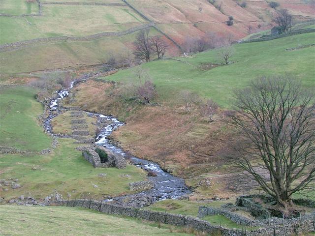
The site is a scheduled monument, scheduled on 24 October 1997, on National Trust land. The wheelpit survives well with walls up to 3.5 metres high, the eleven launder piers stand in a line along the gill, and the lower courses of the two pump-rod pillars remain either side of Pasture Beck. The shaft is largely infilled, and spoil heaps, dressing waste and the stone spread of the gin circle lie around it. Photographs from 2006 and 2016 show the wheelpit and launder piers as the most obvious remains.
The wheelpit, eleven stone launder piers, two pump-rod pillars, the infilled shaft, the gin circle, spoil heaps and dressing waste, leats, two adits and a buried stone-lined tail race.
Redevelopment
None: the remains are a scheduled monument on National Trust land.
Nearby mines
- Hartsop Hall Mine — 2.3 km W
- Kirkstone Slate Quarry — 4.3 km S
- Greenside Mine — 5.4 km NW
- Eagle Crag Mine — 6.0 km W
- Troutbeck Park Green Slate Works — 6.2 km S
Straight-line distance, within 15 km. Show on the map.
What's uncertain
Points where sources disagree or the record could not be settled; both accounts are kept. All open questions in the archive.
- The mine was worked for lead between 1867 and 1870 and proved a commercial failure. (disputed) 1,3
- The Patterdale Mining Company began sinking the shaft about 1870; in the late 1870s the miners broke into a large cavity, the shaft flooded and the mine was abandoned after less than ten years. (disputed) 4
Recorded claims
Individual factual claims, each attached to the source(s) that support it below. Where sources disagree, both are kept.
- Low Hartsop Mine is also called Myers Head Mine. 1
- The Low Hartsop Mining Company started a shaft on the west side of Pasture Beck in about 1866; by the end of 1867 it was 60 m deep with a 24 m crosscut, but water seepage was severe. 2
- The mine was worked for lead between 1867 and 1870 and proved a commercial failure. (disputed) 1,3
- The Patterdale Mining Company began sinking the shaft about 1870; in the late 1870s the miners broke into a large cavity, the shaft flooded and the mine was abandoned after less than ten years. (disputed) 4
- A 30-foot waterwheel beside Hayeswater Gill worked a Cornish pump, fed by a launder on 11 stone-built supports. 4,5,3
- Myers Head lead mine was scheduled on 24 October 1997 (list entry 1015652). 4,5
Photographs & further reading
The full description of the shaft, wheelpit, launder piers, gin circle and adits, with the mine's history.
View sourceThe Low Hartsop and Myers Head workings, with the 1867 shaft depth and the struggle against water.
View sourceSources
- (secondary) Hartsop Dodd — Wikipedia
- (secondary) Mines and Quarries in the Ullswater Valley — Friends of the Ullswater Way
- (observational) Former Myers Head Lead Mine (photograph, 2006) — Geograph Britain and Ireland
- (primary) Myers Head lead mine (list entry 1015652) — Historic England scheduling text, reproduced by ancientmonuments.uk
- (primary) Myers Head lead mine shaft alongside Hayeswater Gill, Howe Green Farm, Ullswater (MNA121341) — National Trust Heritage Records Online
- (observational) Myers Head Mine (photograph, 2016) — Geograph Britain and Ireland
- (secondary) Myers Head Mine, Hartsop — Old Cumbria Gazetteer (quoting Postlethwaite, 1877)
Record created: 18 September 2026 · Last researched: 18 September 2026