 MineArchive
Hartsop Hall Mine
| Location | Low Wood, above Brothers Water, Hartsop, Patterdale, Cumbria — 54.4989, -2.9367 (approximate) |
|---|---|
| Commodities | Lead, Silver |
| Type | Metal |
| Worked | By 1684–1942 |
| Maximum depth | Unknown. |
| Operators | Lowther family (1684–?), Kennedy, Whiteside, Head, Jameson and Company (1866–1871), Greenside Mining Company (1888–1888), Hartsop Mines Limited (1941–1954) |
Overview
A small, very old lead mine in the woods above Brothers Water, at the foot of Hartsop above How, named after the manor house of Hartsop Hall and probably the oldest mine in the Ullswater valley. Leased from the Lowthers from the 1680s and worked only now and then, it was reopened by a Shaw family syndicate in 1931 and closed by the war in 1942; the National Trust, which acquired the land, would not let it restart.
History
Leases between Sir John Lowther of Whitehaven and various parties survive for 1684 to 1696, when the vein was worked from bell pits and open casts before blasting powder came into use; a 21-year lease was signed in 1696, and successive leases involving the Lowthers, the Lonsdales and others kept the mine in being for two and a half centuries. Thomas Dodd took a lease in 1802, ending a period of abandonment, but gave up on 4 June 1804. Kennedy, Whiteside, Head, Jameson and Company worked it from November 1866, and by March 1867 No. 4 adit had been driven 40 fathoms, though the miners complained of low wages and there was too little water to run the machinery. From November 1868 the company was in dispute with the tenant of Hartsop Hall, Mr Backhouse, over dressing waste run into the streams, which was killing fish and livestock; by November 1870 the quarrel had stopped work, and the mine was abandoned in 1871. The Greenside Mining Company reopened it in August 1888, but it then lay idle until 1931, when a syndicate of W. T. Shaw, T. Shaw and J. Myles began again, only for lead prices to close it; they restarted in 1934 on limited capital. In April 1941 J. H. Clay of Caldbeck Mine Ltd joined them and the syndicate became Hartsop Mines Limited, but wartime conditions closed the mine in 1942. On the death of the Earl of Lonsdale the National Trust acquired the land, and the conditions it imposed made profitable working impossible; the company went into voluntary liquidation in 1954.
Geology
The Hartsop Hall Vein runs north-east to south-west and hades west at about one fathom in three. It was generally about three feet wide, carrying argentiferous galena in a matrix of quartz and smashed country rock with a good deal of baryte; the National Trust's record gives 35 ounces of silver to the ton of lead, and the Friends of the Ullswater Way up to 30 ounces to the tonne. Zinc blende, fluorspar, wulfenite and copper also occur, and modern panners have found specks of gold nearby.
Geological setting: Hydrothermal Deposits (well documented example), Veins and Lodes (well documented example)
Workings
Four levels driven northward into the fellside of Hartsop above How, with extensive excavations above and between them; Level 3 shows gunpowder blast holes and may be an older level later widened. A leat about a mile long brought water from Dovedale Beck to a waterwheel, and the mine had a smithy, a joiner's shop and offices. Two collapsed shafts follow the course of the vein. A Cumbrian Amenity Trust plan held by the BGS shows a section of the mine with proposed development.
Closure
Wartime conditions stopped work in 1942. The owners meant to restart, but after the Earl of Lonsdale's death the National Trust acquired the land and its conditions made working unprofitable; Hartsop Mines Limited went into voluntary liquidation in 1954. The Mining Remediation Authority's abandonment plan is dated 27 August 1949, and one account says the leases ran to 1947.
What remains
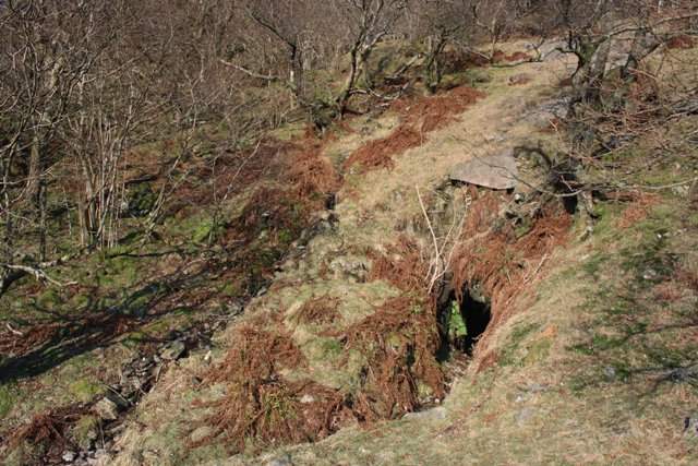
The adits lie in Low Wood, a stand of native woodland above Brothers Water on National Trust land; a 2008 photograph shows the main adit mouth half hidden in bracken among the trees. The surface buildings went about 1860, their stones built into a new barn at Hartsop Hall and an extension of the Brotherswater Hotel, and the waterwheel was moved to Stock Beck in Ambleside. The plant was cleared after 1942, leaving the site much as it was in 1931, and a 1977 photograph published by the Friends of the Ullswater Way shows the mine's headrace.
Adit mouths, collapsed shafts on the vein, the course of the mile-long leat from Dovedale Beck, and spoil in Low Wood.
Redevelopment
The land has belonged to the National Trust since the 1940s; the surface buildings' stone went into a barn at Hartsop Hall and an extension of the Brotherswater Hotel.
Related mines
- Greenside Mine — The Greenside Mining Company, Greenside's operator, reopened Hartsop Hall in August 1888.
Nearby mines
- Kirkstone Slate Quarry — 3.4 km S
- Greenside Mine — 5.3 km N
- Greenhead Gill Mine — 5.5 km SW
- Troutbeck Park Green Slate Works — 6.2 km SE
- Applethwaite Fell Slate Works — 9.0 km S
Straight-line distance, within 15 km. Show on the map.
People
- J. H. Clay · partner, 1941–1942 — Of Caldbeck Mine Ltd; joined the Shaw syndicate in April 1941 to form Hartsop Mines Limited.
- Thomas Dodd · lessee, 1802–1804 — Took a lease in 1802 that ended a period of abandonment; he gave up on 4 June 1804.
- Sir John Lowther · landowner, 1684–1696 — Of Whitehaven; leases between him and various parties for the mine survive from 1684 to 1696.
- J. Myles · partner, 1931–1942 — Member of the 1931 syndicate that reopened the mine.
- T. Shaw · partner, 1931–1942 — One of the Shaw family syndicate that reopened the mine in 1931.
- W. T. Shaw · partner, 1931–1942 — One of the Shaw family syndicate that reopened the mine in 1931 and again in 1934.
What's uncertain
Points where sources disagree or the record could not be settled; both accounts are kept. All open questions in the archive.
- Considerable quantities of lead ore were raised from excavations above and between the adit levels. (disputed) 5
- Four levels were driven into the fellside but the production of ore was never significant. (disputed) 4
- The ore carried about 35 ounces of silver per ton of lead. (disputed) 1
- The lead yielded up to 30 ounces of silver per tonne. (disputed) 2
Recorded claims
Individual factual claims, each attached to the source(s) that support it below. Where sources disagree, both are kept.
- Leases between Sir John Lowther of Whitehaven and various parties cover 1684 to 1696, when bell pits and open-cast working preceded the use of blasting powder. 1
- A 21-year lease to work the mine was signed in 1696, and it is probably the oldest mine in the Ullswater valley. 2,3
- From November 1868 the company was in dispute with the tenant Mr Backhouse over dressing waste in the streams killing fish and livestock; the quarrel had stopped work by November 1870 and the mine was abandoned in 1871. 1
- A Shaw family syndicate reopened the mine in 1931; with J. H. Clay it became Hartsop Mines Limited in 1941, and wartime conditions closed the mine in 1942. 1,4
- Considerable quantities of lead ore were raised from excavations above and between the adit levels. (disputed) 5
- Four levels were driven into the fellside but the production of ore was never significant. (disputed) 4
- The ore carried about 35 ounces of silver per ton of lead. (disputed) 1
- The lead yielded up to 30 ounces of silver per tonne. (disputed) 2
- After the Earl of Lonsdale's death the National Trust acquired the land and its conditions made working unprofitable; the company went into voluntary liquidation in 1954. 1,6
Photographs & further reading
The fullest history: the Lowther leases, the 1860s company and the pollution dispute, and the Shaw syndicate of 1931-42.
View sourcePlaces Hartsop Hall among the valley's other mines, with the silver content and associated minerals.
View sourceSources
- (primary) Large adit level at Hartsop Hall lead mine (Level 3), Hartsop Hall Farm (MNA115715) — National Trust Heritage Records Online
- (secondary) Mines and Quarries in the Ullswater Valley — Friends of the Ullswater Way
- (secondary) Mines and Mills 1680 - 1962 (Emma Bray) — Friends of the Ullswater Way
- (secondary) Hartsop above How — Wikipedia
- (secondary) Hartsop Hall Mine, Patterdale — Old Cumbria Gazetteer (quoting Postlethwaite, Mines and Mining in the English Lake District, 1877)
- (observational) Hartsop Hall Mine, the main adit (photograph, 2008) — Geograph Britain and Ireland, via Wikimedia Commons
- (primary) Abandonment plan OM14515, HARTSOP HALL (lead ore), abandoned 27 August 1949 — BGS / Mining Remediation Authority mine plans catalogue
- (primary) Mine plan CT279, HARTSOP HALL MINE: section showing proposed development — BGS / Cumbrian Amenity Trust Historical Mining Society mine plans

Record created: 18 September 2026 · Last researched: 18 September 2026