 MineArchive
Bog Mine
| Location | The Bog, Stiperstones, Shropshire — 52.5730, -2.9430 (approximate) |
|---|---|
| Commodities | Lead, Barite, Silver, Zinc |
| Type | Metal |
| Worked | 1730s–1924 |
| Maximum depth | 175 fathoms (about 320 m), reached in the 1870s |
| Operators | Stiperstones Company (1864–1871), Bog Mining Company (1871–?), Shropshire Mines Ltd (1917–1924) |
Overview
The Bog, on the edge of the Stiperstones, was one of Shropshire's oldest and longest-worked lead mines, growing from open moorland into a full mining village over nearly two centuries before falling silent in the 1920s — its former school now the area's visitor centre.
History
Mining at The Bog began in the 1730s, working the Bog Vein alongside the neighbouring Mytons Beach and Perkins Beach workings, and continued for close to two hundred years. The Shropshire Historic Environment Record gives the first reference to the mine as 1729, when Matthew Dore and partners were working it, though one account it quotes has 1739. In 1777 the owners, John Scott and Jonathan Edwards, bought a Boulton and Watt engine from Birmingham to pump out the water, and by 1797 the Bog was being worked with Pennerley and other mines and drained by the Boat Level, an adit driven 1.75 miles south from the Minsterley Brook valley to reach it 312 feet below the surface; around the turn of the 19th century it gained its reputation for richness. By 1793 around a hundred miners and their families already lived at the site, and the settlement grew through the 19th century into a proper mining village with rows of cottages, a pub and a school alongside the mine buildings themselves; major phases of work are recorded through the 1830s-40s, 1850s and 1860s-80s. By 1835 the engine shaft was 50 fathoms below the Boat Level, 612 feet deep; a Cornish engine was bought to drain it and the mine was deepened to 163 fathoms by 1844, but profits did not follow, the mines and smelt mills were put up for sale that year, and the Bog flooded once its equipment was sold. The Stiperstones Company took the lease in 1864 and had the mine fitted out, with another engine, by 1870; the Bog Mining Company took over in 1871, but the mine was not dry until 1873 and output stayed low even as it was extended to 175 fathoms, and a contour dam some 300 yards long was completed in 1872 to store water for engine condensing and ore dressing. As lead output declined toward the end of the 19th century, the mine turned to barytes instead, worked on into the early 20th century; in 1917, with the country short of workers during the First World War, Shropshire Mines Ltd drove a new 123-metre level — known ever since as the Somme Tunnel — specifically to provide employment for miners otherwise out of work, and in the same year installed a five-mile aerial ropeway, built with the help of German prisoners of war, to carry barytes for treatment at Minsterley. The HER credits the barytes working during and after the war to Sir James Ramsden, whose shaft was sunk in 1915, and puts the ropeway to the crushing mill at Minsterley in operation from 1916; gas engines drove the pumping and winding, with a small gasworks built on the site because no mains supply was available. The mine finally fell silent in 1922-24, and most of its buildings were subsequently demolished.
Geology
The mine worked the Bog Vein and associated lodes, running broadly east-west and dipping around 45 degrees to the south, within the Shropshire lead-mining district's Ordovician rocks around the Stiperstones. The HER names the host rock as the Mytton Flags; the vein mineral lay in soft country rock that was easy to work, which made the mine popular with local miners, and it yielded lead ore with small amounts of zinc and silver, and later barytes.
Geological setting: Hydrothermal Deposits (well documented example), Strike and Dip (well documented example), Veins and Lodes (well documented example)
Workings
Three shafts — Weston's, Bunting's and Engine — were sunk in succession along the Bog Vein from east to west. The 1917 Somme Tunnel, a 123-metre level, was driven specifically to provide work for otherwise unemployed miners during the First World War, and the same year's five-mile aerial ropeway, built with German prisoner-of-war labour, carried the mine's barytes output to Minsterley for processing. The Bog Vein ground was worked in four main areas, the southernmost including surface workings for barytes, all connected underground by the Boat Level; other shafts on the sett included Hoskins, Tews Nos. 1 and 2, Swag, an incline shaft, and Ramsden's Shaft of 1915, with the Nipstone Adit leading to a stope. The engine shaft reached 612 feet by 1835, 163 fathoms by 1844 and 175 fathoms in the 1870s. The surface buildings were never extensive and the ore was dressed at Minsterley; the 1872 contour dam was later crossed by a tramway taking barytes from Ramsden's Shaft to the head of the ropeway.
Closure
Lead gave way to barytes production in the early 20th century, and the mine finally closed in 1922-24; most of its buildings were later demolished, leaving the former school as the site's principal surviving structure. J. S. Heathcote's survey of the south Shropshire metal mines gives abandonment dates of 1913 and 1925. The earlier collapse came in 1844, when the mine was sold up and left to flood.
What remains
The former village school, a gas-lit Victorian building, survives as the Bog Visitor Centre — one of the few original buildings remaining from the lost mining village. The Somme Tunnel survives. Of the mine itself, the powder magazine survives intact beside the gated Somme Tunnel, along with the 1872 contour dam and a 20th-century adit portal, and a headstock has stood over Ramsden's shaft. Safety works in 1983 examined nine shafts and three adits and uncovered the top of Engine Shaft with the probable remains of two pumping engines, and in 2014 the Shropshire Caving and Mining Club and Shropshire Mines Trust recorded several concrete machine bases and a driving-wheel pit at the ropeway terminus. The site is owned by the County Council, which has put up interpretation boards.
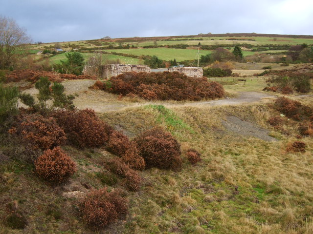
Traces of the aerial ropeway's footings, the powder house and other mine features survive across the site, now part of the Stiperstones National Nature Reserve. Among them are the 300-yard contour dam of 1872, the gated Somme Tunnel beside the intact powder magazine, a 20th-century adit portal, and the machine bases and wheel pit of the ropeway terminus.
Redevelopment
Most of the tips were removed for road metal in the 1970s, the shafts were made safe in 1983 and much of the site was reclaimed in the 1980s, with most remaining buildings cleared for conifer planting; the former school is now the Bog Visitor Centre.
Related mines
- Potter's Pit — Combined with Pennerley and Tankerville into the Tankerville Great Consols company, 1879-80.
Nearby mines
- Pennerley Mine — 0.9 miles (1.4 km) NW
- Tankerville Mine — 1.2 miles (1.9 km) NW
- Burgham Mine — 1.3 miles (2.0 km) N
- Potter's Pit — 1.6 miles (2.6 km) N
- Sallies Mine — 1.6 miles (2.6 km) E
Straight-line distance, within 9 miles (15 km). Show on the map.
What's uncertain
Points where sources disagree or the record could not be settled; both accounts are kept. All open questions in the archive.
- The first reference to the Bog Mine is in 1729, when it was operated by Matthew Dore and partners. (disputed) 2
- The first reference to the Bog Mine is in 1739. (disputed) 2
- The aerial ropeway to Minsterley is suggested to have operated from 1916, according to a 2014 investigation of its terminus. (disputed) 2
- A survey of the south Shropshire metal mines gives abandonment dates of 1913 and 1925. (disputed) 2
Recorded claims
Individual factual claims, each attached to the source(s) that support it below. Where sources disagree, both are kept.
- By 1793 around a hundred miners and their families lived at the mine; by the 1850s the settlement had grown to include rows of cottages, a pub and a school. 1
- The 1917 Somme Tunnel is a 123-metre level driven by Shropshire Mines Ltd specifically to provide work for unemployed miners, and the same year's aerial ropeway, built with German prisoner-of-war labour, carried barytes five miles to Minsterley for treatment. 1
- The first reference to the Bog Mine is in 1729, when it was operated by Matthew Dore and partners. (disputed) 2
- The first reference to the Bog Mine is in 1739. (disputed) 2
- In 1777 the owners John Scott and Jonathan Edwards bought a Boulton and Watt engine from Birmingham to pump out the mine. 2
- By 1797 the Bog was worked with Pennerley and other mines and drained by the Boat Level, which runs 1.75 miles south from the Minsterley Brook valley and reaches the Bog 312 feet below the surface. 2
- By 1835 the engine shaft was 612 feet deep; with a Cornish engine the mine was deepened to 163 fathoms by 1844, when it was put up for sale and flooded. 2
- The Stiperstones Company took the lease in 1864; the Bog Mining Company took over in 1871, but the mine was not dry until 1873 and output stayed low despite reaching 175 fathoms. 2
- Sir James Ramsden worked the mine for barytes during and after the First World War, with gas engines for pumping and winding and a small gasworks on the site. 2
- The aerial ropeway to Minsterley is suggested to have operated from 1916, according to a 2014 investigation of its terminus. (disputed) 2
- A survey of the south Shropshire metal mines gives abandonment dates of 1913 and 1925. (disputed) 2
- Safety works in 1983 uncovered the top of Engine Shaft and the probable remains of two pumping engines. 2
Photographs & further reading
The fullest account of the mine: its owners from 1729, the engines and the Boat Level, the depths, the barytes era under Sir James Ramsden, and surveys of the remains from 1979 to 2014.
View sourceSources
- (secondary) The Bog and Pennerley Mines — Stiperstones and Corndon Hill Country Landscape Partnership
- (primary) The Bog Mine (Shropshire HER MSA1012) — Shropshire Historic Environment Record, via Heritage Gateway
- (primary) Bog Mine Plan (BGS Mine Plans Catalogue) — British Geological Survey
- (secondary) HISTORY & INFORMATION — Bog Visitor Centre
Record created: 22 August 2026 · Last researched: 18 September 2026