 MineArchive
Tankerville Mine
| Location | Shelve, near Worthen, Shropshire — 52.5890, -2.9542 (exact) |
|---|---|
| Commodities | Lead, Barite, Silver, Zinc |
| Type | Metal |
| Worked | From early 19th century–1911-13 |
| Maximum depth | 1,690 feet (deepest shaft in the Shropshire orefield) |
| Operators | Tankerville Mining Company (1870–1884), Shropshire Mines Trust (1996–?) |
Overview
Tankerville, in the Shelve orefield, sank the deepest shaft in the whole Shropshire lead field — 1,690 feet — chasing what turned out to be the richest lead vein in the county, before a collapsing lead price brought the whole venture to a loss-making close within twenty years.
History
Lead mining at Tankerville began on a small scale in the early 19th century, working a small pipe vein reached by a crosscut and a shaft sunk in the 1850s, known as the Oven Pipe. The mine's real development came after 1864, when it was leased to Heighway Jones and managed by Arthur Waters, who deepened the shaft and located what proved to be the richest lead vein in Shropshire. In 1870 the Tankerville Mining Company was floated as a joint stock company to raise capital for expansion, and the mine's shaft eventually reached 1,690 feet — the deepest in the Shropshire orefield. The gradual working-out of the lead ore, combined with a collapse in the price of lead from the mid-1870s, left the company operating at a loss after 1878, and the mine finally closed in May 1884. A reopening attempt between 1891 and 1893 by the Shropshire United Mining Co. Ltd is believed to have recovered lead mainly from surface stock and reworked spoil rather than fresh ore, and a further lease to Shropshire Lead Mines Ltd between 1911 and 1913 also proved unsuccessful. Across its working life between 1865 and 1925, Tankerville produced mainly lead but also barite, calcite, silver and zinc. The site passed to the Shropshire Mines Trust, which acquired the freehold in December 1996.
Geology
The mine worked lead veins of the Shelve orefield, a hydrothermal mineralised belt hosted in Ordovician rocks distinct from the granite-related lodes of Cornwall, reaching what proved to be the richest lead vein recorded anywhere in the Shropshire field.
Geological setting: Hydrothermal Deposits (well documented example), Veins and Lodes (well documented example)
Workings
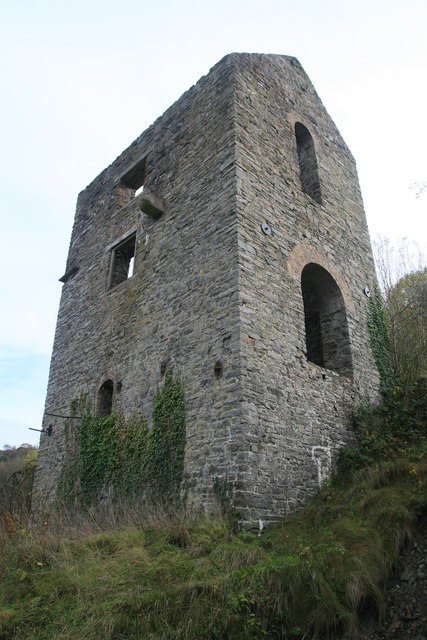
The mine's shaft was deepened from the 1850s Oven Pipe workings to a final depth of 1,690 feet, the deepest in the Shropshire orefield; a small engine house housed a pumping engine on Watson's Shaft, served by an octagonal chimney.
Closure
A collapse in the price of lead from the mid-1870s left the company operating at a loss from 1878, and the mine closed in May 1884; two later reopening attempts, in 1891-93 and 1911-13, both proved unsuccessful.
What remains
The Shropshire Mines Trust acquired the freehold of the site in December 1996 and manages it today, with a recent survey finding a level connecting to both the Ovenpipe and New Shafts.
An engine house on Watson's Shaft and its associated octagonal chimney survive, along with a number of collapsed shafts across the site.
Nearby mines
- Burgham Mine — 0.3 miles (0.4 km) NE
- Pennerley Mine — 0.7 miles (1.1 km) S
- Potter's Pit — 1.0 miles (1.6 km) NE
- Bog Mine — 1.2 miles (1.9 km) SE
- East Roman Gravels Mine — 1.3 miles (2.0 km) W
Straight-line distance, within 9 miles (15 km). Show on the map.
Recorded claims
Individual factual claims, each attached to the source(s) that support it below. Where sources disagree, both are kept.
- The mine's shaft was deepened to a final depth of 1,690 feet, the deepest in the Shropshire orefield, after Heighway Jones and Arthur Waters located the richest lead vein in the county from 1864. 1,2
- A collapse in the price of lead from the mid-1870s left the company operating at a loss from 1878, and the mine closed in May 1884. 1
- The mine was renamed Tankerville in 1870 in honour of Lord Tankerville; production continued into the 1890s, when the machinery was sold off; the lower-level buildings were demolished in the 1950s and 1960s, the shaft made safe in the late twentieth century, and the long wall between the two levels repaired in 2015 by the Shropshire Mines Trust, freeholder since 1996. 2
- The Mining Remediation Authority's abandonment plans catalogue Tankerville with Lewis, Watson's and Engine on the lead and zinc ores at 16 yards to the inch (OM3056) and with Bland's, Lewis, Pennerley and Potter's (OM9465). 3,4
Photographs & further reading
An October 2011 visit to one of the better-preserved lead mines of the Shropshire orefield, just down the road from Snailbeach. Records the shaft as the deepest in the orefield at 1,690 feet — vertical for a short distance, then descending at an angle — the working life of 1865 to 1925 for lead with barytes, calcite, silver and zinc alongside, and photographs of the engine house that held the 40-inch pumping engine, its octagonal chimney, the ore bins and the winding gear.
View sourceSources
- (secondary) Tankerville Lead Mine, Shropshire — Shropshire Caving & Mining Club
- (secondary) Tankerville Mine — Shropshire Mines Trust
- (primary) Tankerville, Bland's, Lewis, Pennerley, Potter's mine plans (BGS Mine Plans Catalogue) — British Geological Survey / The Coal Authority
- (primary) Tankerville, Lewis, Watson's and Engine abandonment plans OM3056 (BGS mine plans catalogue) — British Geological Survey / Mining Remediation Authority
Record created: 24 August 2026 · Last researched: 24 September 2026