 MineArchive
East Roman Gravels Mine
| Also known as | Wood Mine, Hope Valley Mine, Upper Batholes Mine, West Tankerville Mine |
|---|---|
| Location | Hope Valley, near Shelve, Shropshire — 52.5958, -2.9823 (approximate) |
| Commodity | Lead |
| Type | Metal |
| Worked | From 1770s–1883 (final operator liquidated) |
| Maximum depth | Unknown. |
| Operators | Batholes Company Ltd (1847–?), West Tankerville Mining Company Ltd (1870–1882), East Roman Gravels Mining Company Ltd (1882–1883) |
Overview
A lead mine along the Hope Valley in the Shropshire hills, owned by the Earl of Tankerville and worked under a succession of operators from the 1770s to 1883, genuinely distinct from the larger neighbouring Roman Gravels Mine despite the closely similar name.
History
East Roman Gravels Mine, also known as Wood Mine, Hope Valley Mine, Upper Batholes Mine and West Tankerville Mine at various points in its history, was owned throughout by the Earl of Tankerville and stretched for over a mile along the Hope Valley, where the Hope brook had carved out a valley exposing numerous galena veins. Adits were driven into the hillside to exploit these veins from the 18th century, with a drainage tunnel, the Wood Level, delivering good returns in the 1790s. In the 18th century it was part of the Batholes Sett, a group of Hope Valley mines that also took in Batholes Mine. The mine passed through a long succession of operators: John Lawrence and his partners leased the sett in the 1770s and held it until 1831, when Lawrence reluctantly abandoned it to pay the legal debts of his fight with the Leigh Tunnel Company; the Batholes Company Ltd took over in 1847 and concentrated on the Wood Vein, sold the Batholes Mine part of the sett to the newly promoted Hope Valley Company in 1853 after poor returns, and was liquidated in December 1855; Frederick Jones, one of its original partners, held it in a small way from 1855 to 1866; the West Tankerville Mining Company Ltd followed from 1870, with Arthur Waters as mine agent; and finally the East Roman Gravels Mining Company Ltd from 1882. A visitor in 1825 described a horizontal steam engine on site -- a 24-inch cylinder, 4-foot stroke rotary engine used for winding -- as 'one of the most perfect little rotary engines'; a later Cornish beam engine was also installed, alongside an ore crusher house. In 1870 a new 30-inch engine and pumps were installed, but after only a year of pumping the mine was found to be exhausted, and the company turned to new ground at its boundary with Roman Gravels. Accounts of that engine differ: Brook (1977), cited by the Shropshire Historic Environment Record, has the Batholes Company building an engine house for a 30-inch Cornish engine about 1850, which Arthur Waters modified in 1871. A novel 1872 arrangement saw a single engine simultaneously pump and wind ore from three separate shafts -- California, Cornish and the South Boundary -- an unusual technique for the district. By 1874 the company was in trouble and raised £9,000 by issuing preference shares offering 15 per cent dividends. Despite this, the mine's final incarnation as the West Tankerville Mining Company Ltd was liquidated in 1882 and reconstituted as the East Roman Gravels Mining Company Ltd, which itself folded in February 1883, £3,000 in debt, having found no promising ore. The mine is a genuinely distinct operation from the larger, neighbouring Roman Gravels Mine, which had its own separate shaft near the South Boundary vein and its own separate history stretching back to Roman and medieval working.
Geology
The mine worked galena veins exposed where the Hope brook cut down the Hope Valley: from 1847 the Wood Vein, and from 1872 the South Boundary vein it shared with Roman Gravels. The Mining Remediation Authority's abandonment plan records the workings as in lead and zinc ores. The veins lie in the Mytton Flags, according to Heathcote's 1979 survey.
Geological setting: Veins and Lodes (well documented example)
Workings
Adits driven into the hillside from the 18th century to exploit galena veins exposed by the Hope brook, drained by the 1790s Wood Level; later worked via the California, Cornish and South Boundary shafts, the last three eventually served by a single combined pumping-and-winding engine from 1872. Wood's pumping shaft had its own engine house. A 1994 survey by the Shropshire Caving and Mining Club recorded a reservoir, a 19th-century pumping and winding engine house, the collapsed Wood winding shaft and three levels, with Lawrence's Whim Shaft and Black Gin Shaft, both collapsed, nearby.
Closure
The final operating company, East Roman Gravels Mining Company Ltd, was liquidated in February 1883, £3,000 in debt, having found no promising ore. A Mining Remediation Authority abandonment plan of 'Roman Gravels East', whose workings include the California and Cornish shafts, nevertheless gives an abandonment date of 26 April 1901; who worked the ground after 1883 is not recorded. The Shropshire Historic Environment Record describes the main works of 1870 to 1883 as never economically viable, and cites a 1994 Shropshire Caving and Mining Club survey that gives the working life as 1790 to 1930.
What remains
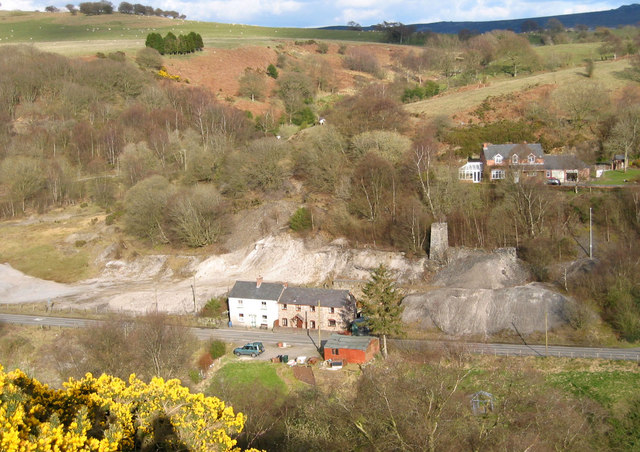
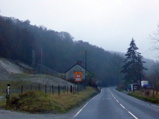
The mine's Cornish beam engine had been demolished by 1985; its horizontal winding engine house was converted into a private dwelling that same year, preserving the structure. The ore crusher house's truncated chimney and foundations remain visible. A photograph of 2014 shows a pale spoil tip of the mine beside the A488, with woodland covering further workings. The Shropshire Historic Environment Record lists one engine house and the chimney of a second engine house or crusher house, with heaps of white spoil beside the A488; in 1999 shafts and adits beside the road were due to be filled as part of road-strengthening works.
A truncated crusher-house chimney and foundations, alongside the former horizontal engine house, now a private dwelling.
Related mines
- Roman Gravels Mine — Genuinely distinct, separately operated mines sharing a closely similar name -- explicitly disambiguated in both records.
Nearby mines
- Roman Gravels Mine — 0.3 miles (0.4 km) SW
- Tankerville Mine — 1.3 miles (2.0 km) E
- Pennerley Mine — 1.4 miles (2.3 km) SE
- Burgham Mine — 1.5 miles (2.4 km) E
- Potter's Pit — 2.1 miles (3.3 km) E
Straight-line distance, within 9 miles (15 km). Show on the map.
People
- Arthur Waters · agent, from 1870 — Mine agent for the West Tankerville Mining Company.
- Arthur Waters · engineer, 1871 — Modified the engine house the Batholes Company had built for a 30-inch Cornish engine, per Brook (1977) cited by the Shropshire HER.
What's uncertain
Points where sources disagree or the record could not be settled; both accounts are kept. All open questions in the archive.
- A Mining Remediation Authority abandonment plan (OM4262) titled 'Roman Gravels East, Black, Gin, California, Cornish, Lawrence's Wood', in lead and zinc ores, gives an abandonment date of 26 April 1901, whereas I.A.Recordings has the mines finally closing with the company's liquidation in February 1883. (disputed) 1,3,4
- The Shropshire HER records the mine as worked from the mid 18th century, and cites a 1994 Shropshire Caving and Mining Club survey giving its working life as 1790 to 1930, against the 1883 closure in I.A.Recordings. (disputed) 6
- Brook (1977), cited by the Shropshire HER, has the mine's best feature as an engine house built about 1850 by the Batholes Company for a 30-inch Cornish engine and modified by Arthur Waters in 1871; I.A.Recordings has a new 30-inch engine installed in 1870. (disputed) 1,6
Recorded claims
Individual factual claims, each attached to the source(s) that support it below. Where sources disagree, both are kept.
- Owned throughout by the Earl of Tankerville, the mine was worked by a long succession of operators: John Lawrence in the 1770s, the Batholes Company Ltd from 1847, Frederick Jones from 1855 to 1866, the West Tankerville Mining Company Ltd from 1870, and finally the East Roman Gravels Mining Company Ltd from 1882. 1
- A visitor in 1825 described the mine's horizontal winding engine -- a 24-inch cylinder, 4-foot stroke rotary engine -- as 'one of the most perfect little rotary engines'. 1
- From 1872 a single engine simultaneously pumped and wound materials from three separate shafts -- California, Cornish and the South Boundary -- an unusual technique for the district. 1
- The mine's final operator, the East Roman Gravels Mining Company Ltd, was liquidated in February 1883, £3,000 in debt, having found no promising ore. 1
- East Roman Gravels Mine is a genuinely distinct operation from the larger, neighbouring Roman Gravels Mine, which had its own separate shaft near the South Boundary vein. 2
- In the 18th century the mine was part of the Batholes Sett, which also included Batholes Mine; John Lawrence and partners leased the sett in the 1770s, and Lawrence abandoned it in 1831 to pay his legal debts from fighting the Leigh Tunnel Company. 1
- The Wood Level drainage tunnel was driven from the Hope Valley under the mine in the 1790s, and good returns were made. 1
- The Batholes Company Ltd, a public company, leased the mine in 1847 and concentrated on the Wood Vein; it sold the Batholes Mine part of the sett to the Hope Valley Company in 1853 after poor returns and was liquidated in December 1855. 1
- In 1874 the West Tankerville Mining Company, already in trouble, raised £9,000 by issuing preference shares offering 15% dividends. 1
- A Mining Remediation Authority abandonment plan (OM4262) titled 'Roman Gravels East, Black, Gin, California, Cornish, Lawrence's Wood', in lead and zinc ores, gives an abandonment date of 26 April 1901, whereas I.A.Recordings has the mines finally closing with the company's liquidation in February 1883. (disputed) 1,3,4
- A photograph of 2014 shows a spoil tip of East Roman Gravels Mine beside the A488, with woodland covering further mining work. 5
- The Shropshire HER records the mine as worked from the mid 18th century, and cites a 1994 Shropshire Caving and Mining Club survey giving its working life as 1790 to 1930, against the 1883 closure in I.A.Recordings. (disputed) 6
- Brook (1977), cited by the Shropshire HER, has the mine's best feature as an engine house built about 1850 by the Batholes Company for a 30-inch Cornish engine and modified by Arthur Waters in 1871; I.A.Recordings has a new 30-inch engine installed in 1870. (disputed) 1,6
- One engine house and the chimney of a second engine house or crusher house survive, with heaps of white spoil beside the A488. 6
- In 1999 Wardell Armstrong Ltd found no further archaeological interest in the mine shafts and adits due to be filled as part of road-strengthening works. 6
- Heathcote's 1979 survey, cited by the Shropshire HER, records the mine's geology as Mytton Flags and its abandonment as 1901. 4
Photographs & further reading
The full industrial-archaeology feature on East Roman Gravels, with its complete succession of owners and engine detail.
View sourceSources
- (primary) East Roman Gravels Lead Mine — I.A.Recordings
- (secondary) Shropshire lead mines — I.A.Recordings
- (primary) Roman Gravels East, Black, Gin, California, Cornish, Lawrence's Wood (abandonment plan OM4262, sheet 3 of 4) — British Geological Survey / Mining Remediation Authority
- (secondary) Roman Gravels Mine (MSA1016) — Shropshire Historic Environment Record, via Heritage Gateway
- (observational) A488 passing a tip from a former mine (photograph, 2014) — Geograph (David Smith)
- (secondary) Group of Mines, Batholes Sett, including East Roman Gravels Mine aka Wood Mine (MSA1015) — Shropshire Historic Environment Record, via Heritage Gateway
Record created: 30 August 2026 · Last researched: 18 September 2026