 MineArchive
Kimmeridge Oil Shale Workings
| Also known as | Kimmeridge Blackstone Workings, Clavell’s Hard Levels, Kimmeridge Shale Mines |
|---|---|
| Location | Kimmeridge Bay and Clavell’s Hard, Isle of Purbeck, Dorset — 50.6120, -2.1288 (approximate, low confidence) |
| Commodities | Oil Shale, Alum, Limestone |
| Type | Mineral |
| Worked | c. 400 BC–c. 1890 |
| Maximum depth | Unknown. Adits driven horizontally into the seam from the cliff face, with one later shaft. |
| Operators | Bituminous Shale Company (1848–1854), Wareham Oil and Candle Company (1857–1872), Kimmeridge Oil and Carbon Company Limited (1883–1890) |
Overview
A single bituminous band in the Upper Jurassic Kimmeridge Clay — the Blackstone, known locally as Kimmeridge coal — has been worked at Kimmeridge Bay on the Isle of Purbeck for something over two thousand years. Iron Age and Romano-British workshops turned it on lathes into armlets, leaving discarded cores that later generations picked off the beach and called coal money. Sir William Clavell burned it to make alum, salt and glass in the early seventeenth century and ruined himself doing so. From 1848 a succession of companies drove levels into the seam from a ledge cut in the sea cliffs at Clavell's Hard and shipped the shale away to be distilled at Weymouth and Wareham. The shale's sulphur content defeated every one of them, and mining ended in the 1890s.
History
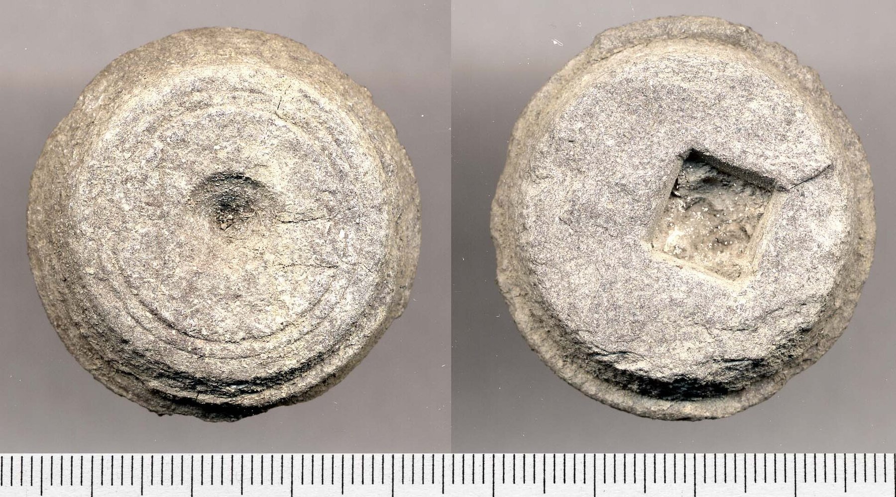
The first exploitation was ornamental rather than industrial. Iron Age people in Purbeck had no local jet, but found that Blackstone polished with beeswax closely resembled it, and established a workshop industry in the bay turning bracelets on pole lathes. The trade survived the Roman conquest and expanded: two workshops were operating in the Romano-British period, armlets from Kimmeridge have been found as far north as Corbridge on Hadrian's Wall, and the shale was also cut into tesserae for the mosaic industry, with a production workshop at Corfe Castle. The circular waste cores discarded from the lathes were common enough on the beach to acquire a local name, coal money. The market for such luxuries died with Roman Britain, and for well over a millennium the shale was simply a local domestic fuel, burned on cottage fires and in bread ovens despite the fumes; Hutchins's History of Dorset priced it in 1774 at ninepence a hogshead, or six shillings a ton.
Industry returned in the 1560s, when Lord Mountjoy found the land at Kimmeridge 'full of allom myne' and took out a patent to make alum there. Nothing came of it, but around 1600 the owner of the manor, Sir William Clavell, took the idea up again, burning Blackstone to work alum from the shale. He perfected the process and was promptly destroyed by it. Merchants holding James I's sole patent for alum travelled a hundred miles to compound with him, agreed a rent of £1,000 a year for his houses, furnaces and coal pits, and then, in his own words, 'broke from all their bargaynes, ruined and ransackes all the allom houses, sold Sir William Clavells stocke of cattell from his ground to his infinite prejudice'. He turned to boiling sea water for salt, using the same shale for fuel, and fell foul of a patent again. In 1617 he took Abraham Bigo into partnership at a glasshouse north of the bay, providing land, finance and Blackstone; when the arrangement soured he sold glass in London in breach of the concession and was twice committed to the Marshalsea. The affair ended in 1626 with an absolute pardon for any crimes he might have committed, witchcraft included. His debts stood at £20,000 and took three generations to clear.
The Victorian phase began in 1848, when the Bituminous Shale Company took a lease of the minerals, laid a tramway and opened a works at Weymouth to distil naphtha, paraffin, paraffin wax, lubricating grease and pitch. Everything it made stank of sulphur. Two years later James Young patented the manufacture of paraffin from bituminous coal; the company fought the patent and lost, on the reasoning that shale was not coal and that 'the manufacture of offensively smelling and unmarketable oils from Kimmeridge Shales should not be held in anticipation of Dr. Young's patent'. Indicted as a public nuisance on top of the costs of the action, it was wound up in 1854. Ferguson and Muschamp set up at Wareham to make fertiliser from the shale and failed inside three years; Wanostrocht & Co. took the works on, won a contract to light Wareham with 130 gas lamps and, with the help of the French ambassador, another to light Paris. Trading latterly as the Wareham Oil and Candle Company it produced some fifty tons of shale oil a month along with gas and 200 tons of fertiliser sold as Kimmeridge Guano, and exported to America as well as France, until its works burned down in 1872. A last effort came with the Kimmeridge Oil and Carbon Company, formed in 1883 out of the Sanitary Carbon Company of Wareham, which invested in a longer tramway, another pier and a shaft. It never worked at scale: by 1889 its manager at Kimmeridge was Thomas George Whiterow, and the 1881 census records only five men in the village employed in the shale and cement trades, all of them Whiterows. By 1891 one resident described himself as a shale miner.
Geology
The cliffs at Kimmeridge expose the Upper Jurassic Kimmeridge Clay Formation, for which the bay is the type locality: alternating beds of shale, clay and dolomite, thick with crushed ammonites. Several bands within it are bituminous enough to burn, but only one was ever worth extracting — the Blackstone, a band of oil shale about a metre thick, at sea level on the west side of the bay and rising eastward with the dip until it outcrops in the cliff face at Clavell's Hard. Its sulphur content, at six to seven per cent, governs the entire industrial history of the place: everything distilled from it smelled, and almost nothing distilled from it sold. Limestone bands in the same succession were mined alongside the shale as cement stone, much of it shipped to the Isle of Wight. The formation is now better known as the principal source rock for North Sea oil.
Geological setting: Sedimentary Beds and Seams (well documented example)
Workings
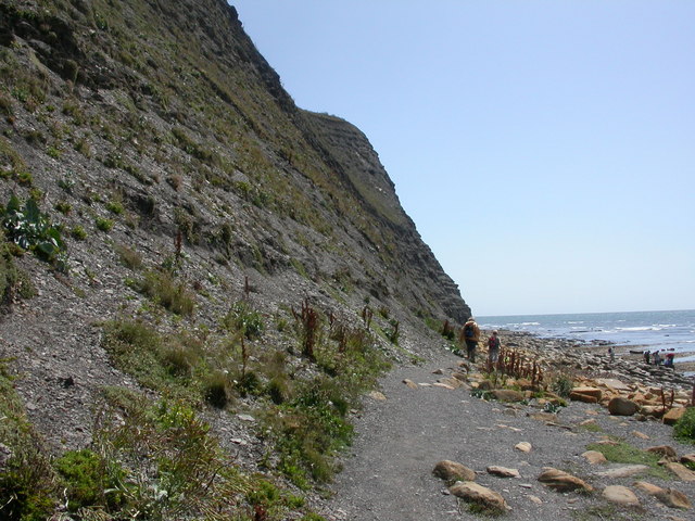
The earliest working was from the surface. A line of old surface workings ran inland from Hen Cliff for some 800 yards along the outcrop, and John Vine, a long-serving Wareham employee giving evidence in 1864, described the 1850s method plainly: strip the earth off the top, work down through five or six feet of slaty stuff to the eight or ten inches of Kimmeridge coal, and take it out by batches. Underground working began in 1857, when Wanostrocht & Co. cut a platform into the sea cliff at Clavell's Hard and drove levels horizontally into the seam from it. There was no road access, so the shale left by sea from an iron pier — a frail structure in a badly exposed position that had a short life — and then from a stone pier on the bay begun in 1858 and eroded almost as quickly. The Kimmeridge Oil and Carbon Company's works after 1883 added a further tramway from a new pier to a level and, further south, to a pit shaft that was linked underground to the earlier No. 1 adit. By about 1890 four main levels had been driven, two of them from the Clavell's Hard ledge, with galleries branching off and roughly 5,000 feet of tunnel in all; a No. 5 level was marked out and never cut. Most of the shale went to Wareham by horse and cart; the limestone went by sea.
Closure
No single event closed the workings; the industry simply ran out of buyers. The Blackstone was thin, expensive to win and heavily sulphurous, and every product made from it was undercut by the coal-derived equivalents that James Young's patent had opened up. Reviewing the field for the Geological Survey in 1898, Aubrey Strahan concluded that notwithstanding the variety of uses to which the coal had been put, it had never paid the expense of extraction, and that at the time of the resurvey the works were almost at a standstill. Arkell reached the same verdict in 1947, attributing the failure to the six to seven per cent sulphur and the thinness of the workable seam, and noting that an annual royalty for the mineral rights was still being paid to the landowner at Smedmore. A series of test boreholes was sunk around Kimmeridge and Portesham in 1917-18 to establish the extent of the shale field in case wartime shortages made it worth having; nothing followed.
What remains
The workings are gone as a going concern and the ground above them is agricultural and park land, but the seam and its adits are still there in the sea cliffs. Ian West's field guide to the Blackstone records the mine entrance and No. 4 level on the ledge at Clavell's Hard, with tufa forming at the entrance, and the surviving lengths of tunnel behind them. Kimmeridge Bay sits within the Jurassic Coast World Heritage Site and the foreshore ledges can only be reached at low tide.
Traces of the adits survive in the cliffs, along with fragments of the piers and tramways. The Royal Commission recorded Sir William Clavell's pier on the east side of the bay as built of large squared blocks laid dry, about 75 yards long and 26 feet wide at the base; it stood until a great storm destroyed it in 1745. Frederick Treves, visiting in 1901, found the ruins of the Victorian pier, the rails laid down from the quarry to the sea and the skeletons of the trucks still on them, with nettles and blackberry growing over the quay. Clavell's seventeenth-century salt, alum and glassworks complex on the east side of the bay is a scheduled monument.
Redevelopment
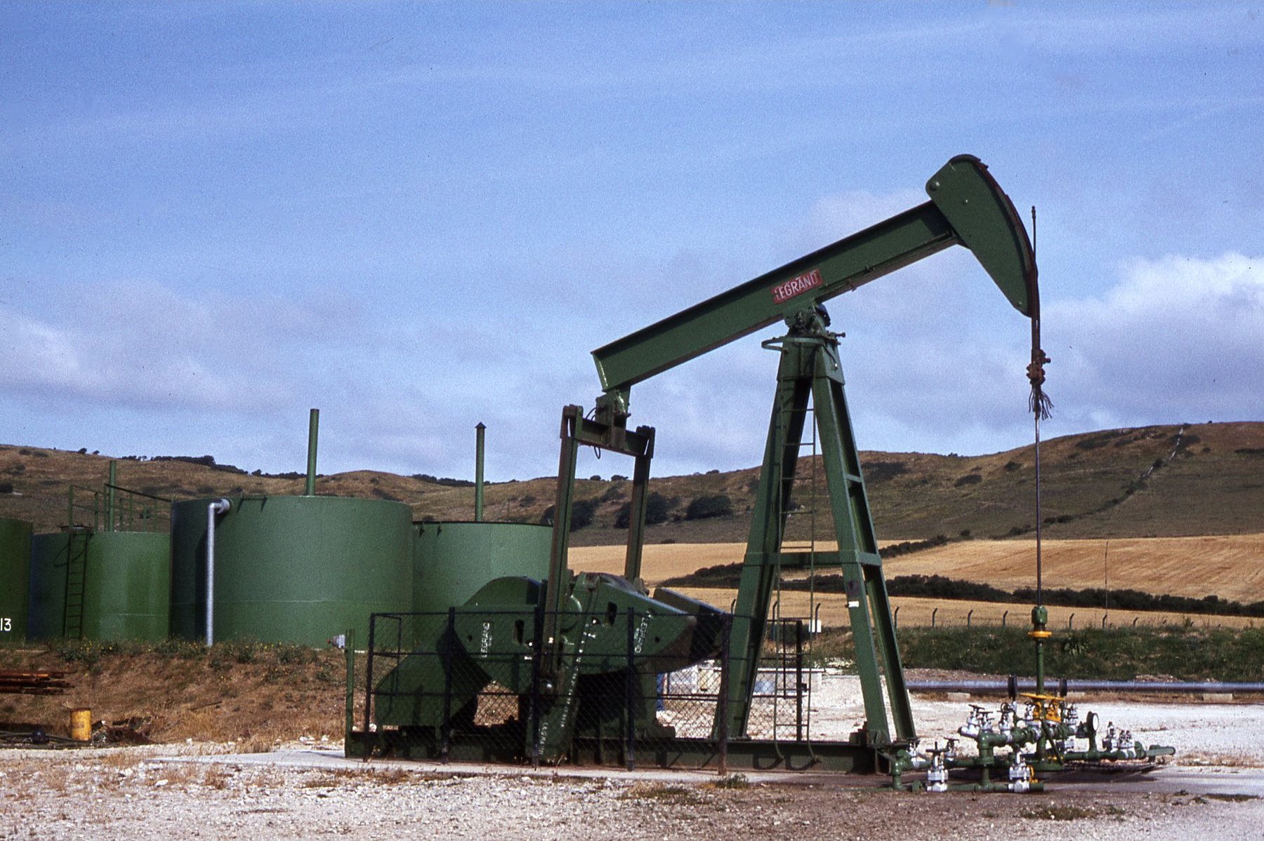
Kimmeridge's minerals found a fourth use in the twentieth century, this time by drilling rather than mining. Oil seepage on the coast drew the petroleum companies; a 1918 survey by Strahan and Pringle rejected the shale as too thin and too sulphurous, and boreholes at Broad Bench in 1936 and 1937 were both abandoned, the second when the drill broke at 943 feet. Work resumed nearer the centre of the bay in the 1950s and Kimmeridge Well One found oil in the Cornbrash below the Oxford Clay, at around 1,790 feet. On 21 October 1968 it became the first English oil well to produce more than 100,000 tons of crude. Its nodding donkey is still pumping, and is now among the most photographed objects on the Dorset coast.
Nearby mines
- Furzebrook and Norden Ball Clay Pits — 3.0 miles (4.9 km) NE
- Winspit — 4.6 miles (7.3 km) SE
- Purbeck Marble Quarries — 4.9 miles (7.8 km) E
- Norman's Quarry — 5.1 miles (8.2 km) E
- Tilly Whim Caves — 7.6 miles (12.3 km) E
Straight-line distance, within 9 miles (15 km). Show on the map.
What's uncertain
Points where sources disagree or the record could not be settled; both accounts are kept. All open questions in the archive.
- Sources disagree on how far Clavell’s ventures actually operated: the Royal Commission inventory states that the alum, salt and glass enterprises "came to nothing", while contemporary accounts quoted by Parkins describe the works in production, including a 1620 Survey of Dorsetshire description of men labouring about the glasshouse fires. (disputed) 1,3
- The identity of the shaft sunk after 1883 is disputed: recent histories, following Ian West’s summary, call it the Manfield Shaft, while the Museum of the Scottish Shale Oil Industry holds that this is an error arising from a misreading of Strahan’s account of the Manfield shale pit at Portesham. (disputed) 4,2
Recorded claims
Individual factual claims, each attached to the source(s) that support it below. Where sources disagree, both are kept.
- The Blackstone is a band of bituminous oil shale about one metre thick, with a sulphur content of six to seven per cent, and Kimmeridge Bay is the type locality for the Kimmeridge Clay Formation. 1,2
- Iron Age and Romano-British workshops in the bay turned the Blackstone on lathes to make armlets; the discarded circular cores became known locally as coal money, and Kimmeridge armlets have been found as far away as Corbridge. 1,3
- Sir William Clavell agreed a composition of £1,000 a year with the holders of James I’s alum patent, who then broke the bargain, ransacked the alum houses and sold his cattle — an account taken from Clavell’s own petition. 1
- Sources disagree on how far Clavell’s ventures actually operated: the Royal Commission inventory states that the alum, salt and glass enterprises "came to nothing", while contemporary accounts quoted by Parkins describe the works in production, including a 1620 Survey of Dorsetshire description of men labouring about the glasshouse fires. (disputed) 1,3
- The Bituminous Shale Company was wound up in 1854 after losing its challenge to James Young’s paraffin patent and being indicted as a public nuisance for the smell of its Weymouth works. 1
- By about 1890 four main levels had been driven, two of them from the mining ledge at Clavell’s Hard, amounting to some 5,000 feet of tunnel, with a fifth level marked out but never cut. 2
- The identity of the shaft sunk after 1883 is disputed: recent histories, following Ian West’s summary, call it the Manfield Shaft, while the Museum of the Scottish Shale Oil Industry holds that this is an error arising from a misreading of Strahan’s account of the Manfield shale pit at Portesham. (disputed) 4,2
- Aubrey Strahan reported in 1898 that the Kimmeridge coal had never paid the expense of extraction and that the works were almost at a standstill; Arkell in 1947 attributed the failure to the sulphur content and the thinness of the seam. 2
- On 21 October 1968 the Kimmeridge oil well became the first English well to produce more than 100,000 tons of crude oil, drawing from the Cornbrash well below the oil shale rather than from the shale itself. 1
Photographs & further reading
Ian West’s illustrated field guide to the Blackstone, photographing the mine entrance, No. 4 level and the tufa forming at the adit mouth on the Clavell’s Hard ledge, and summarising the mining sequence from Mountjoy’s 1560s alum patent to the 1959 oil well.
View sourceA company-by-company account of the Victorian workings, mapping the three main phases and warning that no comprehensive record of the leases survives, so remains on the ground cannot always be matched to a particular operator.
View sourceSources
- (secondary) The Kimmeridge Shale Industry, Dorset (Journal of the Bath Geological Society, 2001) — Bath Geological Society
- (observational) Kimmeridge Field Guide: the Blackstone and the oil shale workings — Ian M. West, School of Ocean and Earth Science, University of Southampton
- (primary) Kimmeridge — An Inventory of the Historical Monuments in Dorset, Volume 2: South East — Royal Commission on the Historical Monuments of England
- (secondary) Kimmeridge Shale Mines — Museum of the Scottish Shale Oil Industry
Record created: 6 September 2026 · Last researched: 6 September 2026