 MineArchive
Wheal Fortune
| Also known as | Great Wheal Fortune |
|---|---|
| Location | Breage and Sithney, Cornwall — 50.1140, -5.3198 (exact) |
| Commodities | Tin, Arsenic, Copper, Tungsten, Zinc |
| Type | Metal |
| Worked | 1855–1912 |
Overview
A tin, copper, zinc, tungsten and arsenic mine straddling the Breage and Sithney parish boundary near Helston, Cornwall, worked on its modern scale from 1855 to the early twentieth century. Part of the site is a Site of Special Scientific Interest and a Geological Conservation Review location, designated for a two-generation tin mineralisation sequence exposed in its opencast workings.
History
Documentary evidence suggests mining activity on the site may date back as far as 1508, under early names recorded as "Cog-an-bans" or "Goghan Bras"; tin veins from this period, known as the Conqueror branches, remain traceable on the ground. The modern mine began working in 1855, and by 1864 employed 457 people across five named lodes (Carnmeal, Blueburrow, Copper, Main and New). Copper was raised until 1884, zinc from 1860 until 1876, and arsenic and tungsten for shorter periods. Recorded tin output totalled 2,992 tons of black tin (2,569 tons 1855-1868, a further 423 tons 1873-1896), alongside 322 tons of copper ore, though the mine's own later account has tin working continuing to 1906. In 1868 the Carnmeal lode was abandoned and five engines in the mine's southern section were put up for sale, but the sett continued to be worked on a reduced scale under different companies until 1912, briefly as "New Great Wheal Fortune" in 1908-09; by 1907 only three people remained employed. A pumping engine of 45 inches was later superseded by a 70-inch engine on Harvey's Engine Shaft, and the northern Carnmeal lode was worked to a depth of 150 fathoms. Even after formal closure, a lone miner is reported to have worked the mine's burrows in the 1950s, recovering about two sacks of wolfram a day.
Geology
The deposit lies in Devonian Mylor Slate Formation metasediments ("killas") close to the roof of the Tregonning-Godolphin Granite, where a later lithium-mica granite phase (the Tregonning Granite) intruded an earlier type-C biotite granite (the Godolphin Granite). Two distinct mineralisation events are exposed here: an early ENE-trending sheeted stockwork of tin-bearing cracks bordered by greisen alteration, carrying tourmaline, topaz, mica ("gilbertite") and cassiterite; and a later phase of hydrothermal tin-vein mineralisation following structural weaknesses, in which an east-west elvan (quartz-feldspar porphyry) dyke that had displaced the earlier stockwork went on to act as a channel for the mineralising fluids. This two-generation sequence, unusually well exposed together in one opencast, is what earned the site its Geological Conservation Review status.
Geological setting: Greisen and Pegmatite Deposits (well documented example), Hydrothermal Deposits (well documented example), Veins and Lodes (well documented example)
Workings
Worked as a combination of opencast and underground workings across five lodes. The main opencast, roughly 300 m south of the engine site and considered of great antiquity, is a large openwork (a "gunnis" or "coffin") about 10 m long and up to 18 m deep, divided in two by a narrow ridge and covering some 0.55 hectares. The northern Carnmeal lode was worked underground to a depth of 150 fathoms via shafts including Harvey's Engine Shaft.
Closure
Main lode production wound down through the 1880s-90s, though the mine's own account has tin working continuing to 1906; the sett was kept going under successive companies, briefly renamed New Great Wheal Fortune in 1908-09, until 1912. Even after that, informal wolfram-scavenging from the burrows is reported into the 1950s.
What remains
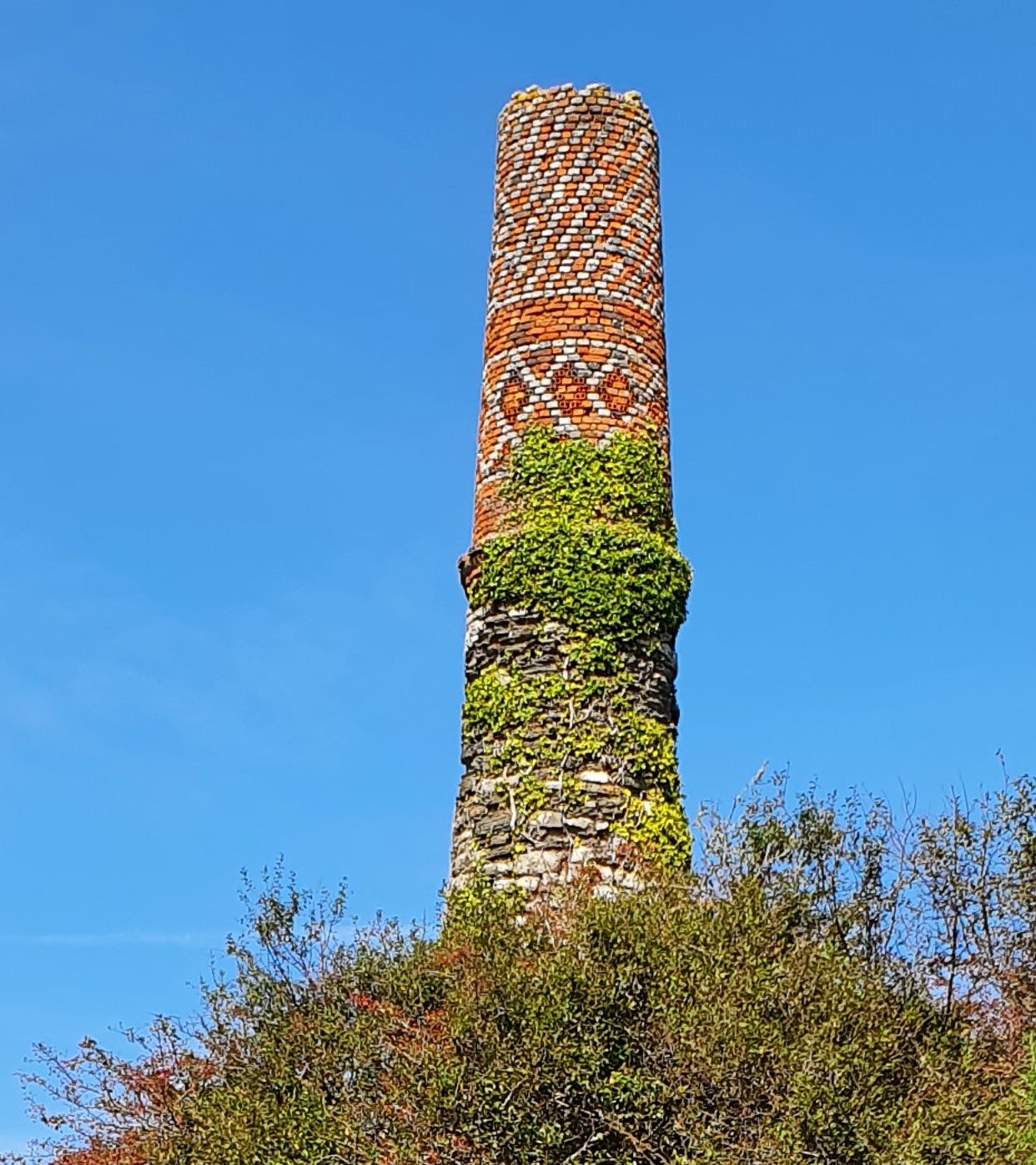
A brick-and-stone engine house chimney survives above the site, its upper courses laid in a decorative diamond pattern typical of Cornish engine houses; it is heavily colonised by ivy over its lower half. A 2007 caving-forum discussion of the site describes the main opencast as "very overgrown," with old exploratory levels at its eastern end that appear to be pre-1855 workings rather than part of the main nineteenth-century sett — consistent with the site's documented earlier history.
The surviving engine house chimney and the large opencast working ("coffin"/gunnis) are the principal visible surface features; the opencast exposes the site's two-generation tin mineralisation, the basis of its SSSI/GCR designation.
Related mines
- Consolidated Mines — Wheal Fortune was one of the older 18th-century workings merged to form Consolidated Mines.
Nearby mines
- Wheal Vor — 0.4 miles (0.7 km) NW
- Wheal Metal — 0.5 miles (0.8 km) N
- Tregonning Hill China Clay Pits — 1.8 miles (2.8 km) W
- Wheal Grey Mine — 2.0 miles (3.3 km) W
- Great Work Mine — 2.2 miles (3.6 km) NW
Straight-line distance, within 9 miles (15 km). Show on the map.
What's uncertain
Points where sources disagree or the record could not be settled; both accounts are kept. All open questions in the archive.
- Documentary evidence suggests mining activity on the site may date to 1508, recorded under early names "Cog-an-bans" or "Goghan Bras"; tin veins from this period, called the Conqueror branches, are still traceable — a 2007 caving-forum discussion of the site independently refers to old, probably 18th-century, exploratory levels at 'The Conqueror' branch. (uncertain) 1,3
- Recorded tin output totals 2,992 tons of black tin (2,569 tons 1855-1868, a further 423 tons 1873-1896), plus 322 tons of copper ore; the GCR account describes main lode production as effectively finished by 1896, while another account has tin extraction continuing to 1906 on a reduced scale — the two describe different things, recorded lode output against the site's working life. (disputed) 1,2
- The mine continued under different companies until 1912, briefly renamed New Great Wheal Fortune in 1908-09; a lone miner is reported to have worked its burrows for wolfram in the 1950s, recovering about two sacks a day. (uncertain) 1
Recorded claims
Individual factual claims, each attached to the source(s) that support it below. Where sources disagree, both are kept.
- The mine straddles the Breage and Sithney civil parish boundary in west Cornwall, about 0.8 km ENE of Breage, near Helston. 1,2
- Documentary evidence suggests mining activity on the site may date to 1508, recorded under early names "Cog-an-bans" or "Goghan Bras"; tin veins from this period, called the Conqueror branches, are still traceable — a 2007 caving-forum discussion of the site independently refers to old, probably 18th-century, exploratory levels at 'The Conqueror' branch. (uncertain) 1,3
- Part of the disused mine was designated a Site of Special Scientific Interest for its geological interest in 1991, and is a Geological Conservation Review site of national importance for its exposure of two generations of tin mineralisation. 1,2
- Recorded tin output totals 2,992 tons of black tin (2,569 tons 1855-1868, a further 423 tons 1873-1896), plus 322 tons of copper ore; the GCR account describes main lode production as effectively finished by 1896, while another account has tin extraction continuing to 1906 on a reduced scale — the two describe different things, recorded lode output against the site's working life. (disputed) 1,2
- The mine employed 457 people at its peak in 1864, falling to just three by 1907. 1
- A 45-inch pumping engine was later replaced by a 70-inch engine on Harvey's Engine Shaft; the northern Carnmeal lode was worked to a depth of 150 fathoms. In 1868 the Carnmeal lode was abandoned and five engines in the mine's southern section were put up for sale. 1
- The mine continued under different companies until 1912, briefly renamed New Great Wheal Fortune in 1908-09; a lone miner is reported to have worked its burrows for wolfram in the 1950s, recovering about two sacks a day. (uncertain) 1
- The deposit formed in two distinct phases above the roof of the Tregonning-Godolphin Granite: an early ENE-trending greisen-bordered stockwork carrying tourmaline, topaz, mica and cassiterite, later disrupted by an east-west elvan dyke that itself went on to channel a second, hydrothermal phase of tin-vein mineralisation along structural weaknesses. 2
- The principal opencast, some 300 m south of the engine site, is a large gunnis/coffin roughly 10 m long and up to 18 m deep, divided by a narrow ridge and covering about 0.55 hectares; five lodes (Carnmeal, Blueburrow, Copper, Main and New) were worked. 1,2
- A plan referencing Wheal Fortune's copper-ore workings survives in the BGS/Mining Remediation Authority mine plans catalogue, filed under a combined abandonment plan for several amalgamated setts ("Clifford Amalgamated Consolidated and United", including several other named Wheal- setts), dated 1870, custodian the Coal Authority. The plan title covers a group of adjoining setts rather than Wheal Fortune alone. 4
- Located at about 50.114 N, 5.320 W. 1
Sources
- (secondary) Great Wheal Fortune — Wikipedia
- (primary) Great Wheal Fortune, Cornwall (Geological Conservation Review site GCR36) — Geological Conservation Review / Scottish Geology Trust GeoGuide
- (observational) Great Wheal Fortune (forum thread) — UK Caving forum
- (primary) Mine plan: Clifford Amalgamated Consolidated and United ... Wheal Fortune ... (abandonment plan, Copper Ore, 1870) — BGS / Mining Remediation Authority mine plans catalogue
Record created: 29 August 2026 · Last researched: 29 August 2026