 MineArchive
Old Gang Mines
| Location | Swaledale, North Yorkshire — 54.3853, -1.9911 (approximate) |
|---|---|
| Commodity | Lead |
| Type | Metal |
| Worked | 18th century–1899-1903 |
Overview
Old Gang, high above Gunnerside in Swaledale, was one of the largest and most productive lead-mining complexes in the Yorkshire Dales, and its smelt mill survives as one of the best-preserved — and most structurally complex — in the whole of the North Pennines.
History
Lead has been worked in this part of Swaledale since Roman times, but the extensive remains visible today date mainly from the 18th and 19th centuries, when Old Gang grew into one of the dale's most productive mines, worked by hundreds of men and boys who dug, crushed and smelted ore straight from the surrounding hillside in often severe weather and dangerous underground conditions. An early smelt mill here was superseded by a larger mill, probably built in 1846, which processed ore brought down from the workings at Hard Level Gill and Friarfold as well as Old Gang's own hushes, levels and shafts. Falling lead prices from the 1880s, driven by cheap imported ore from Spain and the United States, made the operation increasingly uneconomic; smelting activity wound down through the 1890s and had ceased entirely by 1903, after which any remaining local lead was smelted instead at Castleside Mill in County Durham.
Geology
The mines worked lead-bearing veins in the Carboniferous rocks of the northern Pennine orefield, the same broad mineralised belt that runs through Swaledale and Arkengarthdale.
Geological setting: Hydrothermal Deposits (well documented example), Veins and Lodes (well documented example)
Workings
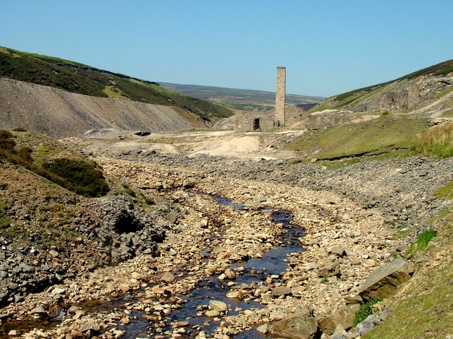
The complex includes an older smelt mill and a large ore-dressing floor alongside levels, hushes and shallow shafts, feeding the later, larger mill; a spoil heap over 500 metres long testifies to the scale of the operation. The surviving mill building, roughly 24 by 10 metres, still stands to roof height in places and contains the remains of a wheelhouse, a slag hearth and three ore hearths, along with a roasting hearth and a separate silver hearth; its tall square chimney remains intact. An adjoining peat store, built of limestone and around 400 feet long with 39 bays, supplied fuel for the smelting hearths.
Closure
Smelting had effectively ceased by the early 1900s as falling lead prices made the operation uneconomic against cheaper Spanish and American imports.
What remains
The smelt mill and its flue are Grade II listed, and the peat store carries a separate Grade II listing; the whole site — including the older mill, mine workings, a miners' hut and a bridge — is a Scheduled Monument, and is considered one of the best-preserved and structurally most complex lead smelt mills in the North Pennines.
Substantial ruins survive across the site: the smelt mill standing to roof height in places, its intact chimney, the long limestone peat store, and the extensive spoil heaps and hush scars on the surrounding moorland.
Related mines
- Sir Francis Level (Lownathwaite Mine) — The 1888 List of Mines returns the Sir Francis sett under the Old Gang Mining Company Limited of Fremington — the company named for, and working, the Old Gang ground a short way down the same Swaledale orefield. The two were in the same hands six years after Sir George Denys gave up the level.
- Surrender Mine — Surrender's ore went to Old Gang Mill after the mill closed in 1880.
Nearby mines
- Sir Francis Level (Lownathwaite Mine) — 0.9 miles (1.5 km) N
- Surrender Mine — 1.1 miles (1.7 km) SE
- Blakethwaite Mine — 1.4 miles (2.2 km) NW
- Booze Mine — 1.5 miles (2.5 km) N
- Whaw Mine — 1.8 miles (2.9 km) N
Straight-line distance, within 9 miles (15 km). Show on the map.
Recorded claims
Individual factual claims, each attached to the source(s) that support it below. Where sources disagree, both are kept.
- Smelting at Old Gang wound down through the 1890s and had ceased by 1903, after which local lead was smelted instead at Castleside Mill in County Durham. 1
- The mill building measures roughly 24 by 10 metres and survives to roof height in places, containing a wheelhouse, slag hearth and three ore hearths; the associated peat store runs to around 400 feet with 39 bays. 1,2
- Dunham's longitudinal section of Lownathwaite and Old Gang along the Old Rake (SP2141, at 1:2400, compiled in 1941 and 1978) shows the levels, shafts, cross-veins, stopes and geology, with the workings on Alderson's and Raw's veins and the Barbara zone, and can be viewed online; the Peak District Mines Historical Society's plan of the main workings is held as MP26751. 3,4
- The 1846 mill, 24 by 10 metres, held a wheelhouse, a slag hearth and three ore hearths, with a roasting hearth and a silver hearth in outbuildings; activity had fallen away by 1885, and the main building was listed Grade II in 1969. 1
Photographs & further reading
The scanned longitudinal section, viewable online.
View sourceSources
- (secondary) Old Gang Mill — Wikipedia
- (primary) Lead mines, ore works and smeltmills at Old Gang on Reeth High Moor, Reeth, Fremington and Healaugh — Historic England (Scheduled Monument List Entry 1015860)
- (primary) Old Gang Mine Plan (BGS Mine Plans Catalogue) — British Geological Survey
- (primary) Plan of the main workings of the Old Gang mines, MP26751 (BGS mine plans catalogue) — British Geological Survey
Record created: 22 August 2026 · Last researched: 24 September 2026