 MineArchive
Sir Francis Level (Lownathwaite Mine)
| Location | Gunnerside Gill, Swaledale, North Yorkshire — 54.3987, -1.9887 (approximate) |
|---|---|
| Commodity | Lead |
| Type | Metal |
| Worked | 1864–1882 |
| Maximum depth | 260 feet |
| Operators | Sir George Denys (1864–1882), Old Gang Mining Company Limited (1888–?) |
Overview
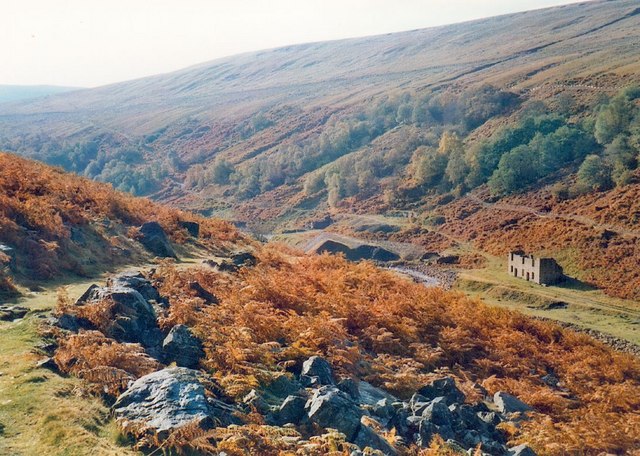
Sir Francis Level, driven nearly a mile into the west side of Gunnerside Gill from 1864, was Swaledale lead-mining landlord Sir George Denys's ambitious attempt to reach deep ore beneath his existing workings — and became, in 1870, the first mine in Yorkshire to use compressed-air rock drills, technology whose underground hydraulic engine survives today as an exceptionally rare relic.
History
Sir Francis Level was started in 1864 on the instruction of Sir George Denys, owner of the mining rights across much of upper Swaledale, and named after his son Francis Denys. The level was driven as a long drainage and exploration tunnel into the west side of Gunnerside Gill, aimed at reaching deep-lying ore in the Fairfold Vein beneath the ground already worked from the Lownathwaite and Blakethwaite mines higher up the gill. Driving began with hand-bored shot holes and black powder, the standard method of the day, but in 1870 Denys had compressed-air drills installed to speed the work — the first use of the technology in a Yorkshire mine. The level eventually ran some 1.4 kilometres (nearly a mile) into the hillside, reaching a shaft sunk to gain access to lower workings and equipped with lift cages and winding gear, which survive underground in good condition. The Fairfold Vein was finally reached at a depth of 260 feet from surface in 1877, but the ore proved insufficient to repay the scale of investment the level had required, and the mine was abandoned in 1882.
The level was not quite finished with in 1882. The 1888 List of Mines under the Metalliferous Mines Act still enters it, as "A. D. Sir Francis" in Swaledale, with John Reynoldson as manager and the Old Gang Mining Company Limited of Fremington, Richmond, as owner — so six years after Denys gave up, the sett had passed to the Old Gang company and was being returned as a working mine. What was actually got there in those years is not recorded.
Geology
The level was driven to reach the Fairfold Vein, a lead-bearing structure within the North Pennine orefield of the Yorkshire Dales, a hydrothermal, non-magmatic mineralisation belt distinct from Cornwall's granite-related lodes.
Geological setting: Hydrothermal Deposits (well documented example), Veins and Lodes (well documented example)
Workings
The adit itself runs approximately 1.4 kilometres (nearly a mile) into the hillside from its portal on the west side of Gunnerside Gill, reaching a shaft with surviving lift cages and winding equipment; the Fairfold Vein was intersected at a depth of 260 feet from surface in 1877.
Closure
The mine was abandoned in 1882 after the ore reached in the Fairfold Vein proved insufficient to justify the level's cost; no later working is recorded.
What remains
The level's underground workings, including its winding gear and an underground hydraulic engine, survive in good condition and are considered an exceptionally rare and significant survival of 1870s mining technology.
A derelictplaces.co.uk exploration report and a dedicated YouTube documentary ('Hidden Hydraulics: Sir Francis Level @ Gunnerside Gill') both describe the level's underground hydraulic engine and winding gear as still substantially intact.
Related mines
- Blakethwaite Mine — Both worked by Sir George Denys's A.D. Mining Company, which drove the Sir Francis Level and smelted at Blakethwaite.
- Old Gang Mines — The 1888 List of Mines returns the Sir Francis sett under the Old Gang Mining Company Limited of Fremington — the company named for, and working, the Old Gang ground a short way down the same Swaledale orefield. The two were in the same hands six years after Sir George Denys gave up the level.
- Sun Hush Mine — Both were returned in the 1888 List of Mines under the Old Gang Mining Company Limited of Fremington with the same agent, John Reynoldson, and both worked the same ground in Gunnerside Gill — Sun Hush a hush and its level on the fellside, Sir Francis the deep level driven below the gill to reach the same veins.
Nearby mines
- Booze Mine — 0.6 miles (1.0 km) NE
- Old Gang Mines — 0.9 miles (1.5 km) S
- Whaw Mine — 0.9 miles (1.5 km) N
- Slei Gill Mine — 1.0 miles (1.6 km) N
- Wetshaw Mine — 1.1 miles (1.8 km) NE
Straight-line distance, within 9 miles (15 km). Show on the map.
Recorded claims
Individual factual claims, each attached to the source(s) that support it below. Where sources disagree, both are kept.
- The level runs approximately 1.4 kilometres into the hillside, reaching the Fairfold Vein at a depth of 260 feet from surface in 1877. 1,2
- Compressed-air rock drills were installed in 1870 to speed the level's driving, the first recorded use of the technology in a Yorkshire mine. 1,2
- The underground hydraulic engine and winding gear survive in good condition and are described by recent exploration reports as an exceptionally rare survival of 1870s mining technology. 2
- The 1888 List of Mines records 'A. D. Sir Francis' in Swaledale, with John Reynoldson as manager or agent and the Old Gang Mining Co. Ltd. of Fremington, Richmond, as owner. 3
Photographs & further reading
A September 2009 underground visit with a clear account of the level's history — begun by Sir George Denys in 1864, named for his son Francis, never commercially successful, and closed in the early 1880s — and of what made it matter: the waterwheel-driven compressor at the entrance that brought compressed-air drills to Yorkshire lead mining in 1870, ventilating the workings as a by-product and saving the cost of driving airshafts.
View sourceA short film of a visit into Sir Francis Level, by David Webb, titled for the hydraulic engineering the level is known for. Video only, with no accompanying written report.
View sourceSources
- (secondary) Sir Francis Level, Lownathwaite Mine, Gunnerside Gill — Mindat
- (secondary) Sir Francis Level Gunnerside Gill — Subterranea Britannica
- (primary) 1888 List of Mines under the Metalliferous Mines Act: Lead Mines (Durham District) — Mines Department, via the Durham Mining Museum
- (primary) Section of Surrender Mine, Sir Francis Level, Lownathwaite Mine — British Geological Survey / Institute of Geological Sciences
Record created: 22 August 2026 · Last researched: 5 September 2026