 MineArchive
Surrender Mine
| Location | Swaledale, North Yorkshire — 54.3775, -1.9683 (approximate) |
|---|---|
| Commodity | Lead |
| Type | Metal |
| Worked | before 1720–1880 |
| Operators | Surrender Company (1841–1880) |
Overview
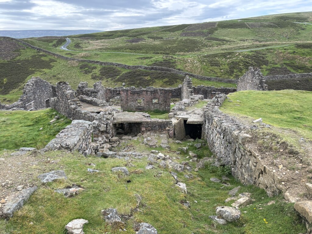
Surrender, in Swaledale, was among the district's principal lead mines, and its smelt mill — rebuilt in 1841 to replace two older watermills — survives today as one of the best-preserved 19th-century lead smelting complexes in the Yorkshire Dales.
History
Two earlier watermills, known as the Low Mills, were built before 1720 to smelt lead from the Surrender workings. In 1841 the Surrender Company replaced both with a single new mill, built as part of a lease agreement that had required the lessees to construct a new mill and flue within two years; that mill's own 1841 accounts record 54 tons of lead smelted with no slag produced, suggesting an efficient operation from the outset. A long flue was extended to a chimney some 745 metres away in 1854, allowing better recovery of lead from the smelting fumes. When the A.D. Mining Company, one of the mill's major customers, began selling its ore to other smelters from 1879, Surrender's mill could not sustain its business and closed the following year, in 1880; its own ore thereafter went instead to the nearby Old Gang Mill. The mill buildings were maintained for a further two decades before being stripped for salvage — roofs, doors and floorboards sold off in 1902, and the mill's own 14-foot waterwheel sold in 1909.
Geology
The mine worked lead-bearing veins in the Carboniferous rocks of the northern Pennine orefield, the same broad mineralised belt worked at the neighbouring Old Gang complex elsewhere in Swaledale.
Geological setting: Hydrothermal Deposits (well documented example), Veins and Lodes (well documented example)
Workings
The 1841 mill was powered by a substantial waterwheel — 14 feet in diameter, eventually sold for scrap in 1909 — which drove bellows for the smelting hearths; its wheel pit survives on site. Fuel for the hearths came mainly from peat, dried and stored in a large open-sided peat store on the site. The 1854 flue extension, running 745 metres to a chimney, improved the recovery of lead particles from the furnace fumes.
Closure
The mill closed in 1880 once its main ore customer began selling elsewhere, was gradually stripped of reusable materials over the following three decades, and has stood as a ruin since.
What remains
The mill survives as a substantial ruin — its gable end and side walls standing, with five doorways and three window openings still visible — and is a Grade II listed building and Scheduled Monument, alongside the separately listed remains of its peat store, some 188 by 20 feet.
The wheel pit that once housed the mill's waterwheel, and the ruined peat store, survive alongside the mill itself on the banks of Barney Beck.
Related mines
- Blakethwaite Mine — The A.D. Mining Company smelted Blakethwaite's ore at Blakethwaite mill until 1878, then moved the smelting to its Surrender Mill.
- Old Gang Mines — Surrender's ore went to Old Gang Mill after the mill closed in 1880.
Nearby mines
- Old Gang Mines — 1.1 miles (1.7 km) NW
- Sir Francis Level (Lownathwaite Mine) — 1.7 miles (2.7 km) NW
- Grinton Smelt Mill — 2.0 miles (3.1 km) SE
- Whiteside Mine — 2.0 miles (3.2 km) SE
- Booze Mine — 2.1 miles (3.4 km) N
Straight-line distance, within 9 miles (15 km). Show on the map.
Recorded claims
Individual factual claims, each attached to the source(s) that support it below. Where sources disagree, both are kept.
- The mill's own 1841 accounts recorded 54 tons of lead smelted and no slag produced that year. 1
- The mill closed in 1880 after its major customer, the A.D. Mining Company, began selling its ore to other smelters from 1879; the building was subsequently stripped for salvage, with its roof, doors and floorboards sold in 1902 and its waterwheel sold in 1909. 1
- Dunham's cross and longitudinal sections of Surrender Mine (SP2140, compiled in 1941 with additions to 1978) and his 1980 section across Surrender and along Sir Francis Level and Lownathwaite, showing Surrender High Shaft and borehole G.1 (SP2146), are held by the British Geological Survey and can be viewed online. 2,3
- The mill's 14-foot waterwheel was sold in 1909; the ruin was listed Grade II in 1973, with the peat store separately, and the peat store, 188 feet long by 20 wide, keeps its gable walls and one pair of piers. 1
Photographs & further reading
The scanned sections, viewable online.
View sourceSources
- (secondary) Surrender Mill — Wikipedia
- (primary) Surrender Mine Plan (BGS Mine Plans Catalogue) — British Geological Survey
- (primary) Section of Surrender Mine, Sir Francis Level and Lownathwaite, SP2146 (BGS mine plans catalogue) — British Geological Survey
- (secondary) Lead Mining in Swaledale — Yorkshire Dales National Park
Record created: 22 August 2026 · Last researched: 24 September 2026