 MineArchive
Cow Green Mine
| Also known as | West Cowgreen Mine, Cowgreen Mine |
|---|---|
| Location | Cow Green, Harwood Fell, Upper Teesdale, County Durham — 54.6570, -2.3080 (approximate) |
| Commodities | Barite, Lead |
| Type | Metal |
| Worked | From late 18th century–1954 |
| Maximum depth | A shaft sunk in 1949 entered the Whin Sill at 20 m. |
| Operators | Hedworth Barium Company Limited (1914–?) |
Overview
Cow Green worked a group of veins in the high fells at the head of Teesdale, first for lead in the late eighteenth and early nineteenth centuries and later, once there was a market for it, for the barytes that surrounded the lead in the same veins. The workings ran until 1954. Part of the ground was drowned when the Cow Green Reservoir was built between 1967 and 1971 to supply the industries of Teesside — flooded, as one account puts it, but not obliterated.
History
The veins at Cow Green were worked in the late eighteenth and early nineteenth centuries, primarily for lead ore. Evidence of that early working is prominent in the landscape still, in the form of hushes, dams and old shafts. Barytes, which lay around the lead in the same veins, was not mined commercially anywhere in the North Pennine orefield until the later nineteenth century, so for the first phase of working here it was simply in the way.
By the twentieth century that had changed. The 1914 List of Mines enters Cow Green at Harwood Fell under the Hedworth Barium Company Limited, working barytes and lead ore with eighteen men underground. The main veins at the principal mine were the Winterhush, Greenhush and Isabella, and the mine was worked until 1954. At Rod's Vein, further along the ground, a shaft was sunk in 1949 which entered the Whin Sill at twenty metres, where the vein narrowed.
The Cow Green Reservoir was built between 1967 and 1971, two miles long, to supply the industries of Teesside; its construction was among the most contested conservation cases of its day because of the rare arctic-alpine flora of Upper Teesdale. A group of the barytes mines was flooded by it — flooded but not obliterated — and the main entrance to the mine is a level now submerged beneath the water.
Geology
The West Cowgreen mines consist of two main veins, the Winter Hush Vein running north-south and the Green Hush Vein north-east to south-west, together with a number of smaller ones including the Angle Vein. These lie in faults that are offshoots to the south of the major Teesdale Fault, which runs north-west to south-east. The lead ore tended to occupy the centre of a vein, surrounded by barytes — which is precisely why the same ground could be worked twice for different minerals.
The Winter Hush Vein consists of a series of lenses of predominantly barytes, with galena more abundant in the narrower sections; the lenses average about 100 metres long and 3 metres wide, with the intermediate sections of the vein about 1.2 metres wide. A bore 80 metres deep sunk through the vein towards its southern end penetrated the Whin Sill, and within the Sill the vein consists entirely of witherite, the barium carbonate. The fault downthrows to the east by up to 30 metres, though with hardly any displacement in places.
Rod's Vein was worked opencast in the Melmerby Scar Limestone, the main vein being 1.1 to 1.8 metres wide. That limestone outcrops nearby as the celebrated 'sugar limestone' of Upper Teesdale — white, crystalline and weathering to a distinctive crumble, and in fact a marble, recrystallised by the heat of the Whin Sill intruding beside it. The Smiddy Limestone in the same ground is fossiliferous, with crinoid fragments and small brachiopods and a bioherm built by corals about 330 million years ago.
Geological setting: Faults and Fractures (well documented example), Veins and Lodes (well documented example)
Workings
Opencast and underground working on a group of veins. The early lead phase left hushes, dams and old shafts, still prominent on the fell. The main veins at the principal mine were the Winterhush, Greenhush and Isabella. Rod's Vein was worked opencast in the Melmerby Scar Limestone, with a shaft sunk beside it in 1949 that reached the Whin Sill at twenty metres. An 80-metre bore was put down through the Winter Hush Vein at its southern end. The main entrance to the mine was a level now under the reservoir.
Closure
The mine was worked until 1954. Thirteen years later the building of the Cow Green Reservoir began, and when it filled between 1967 and 1971 a group of the barytes mines was flooded — not destroyed, but put beyond reach, the main entrance level among them.
What remains
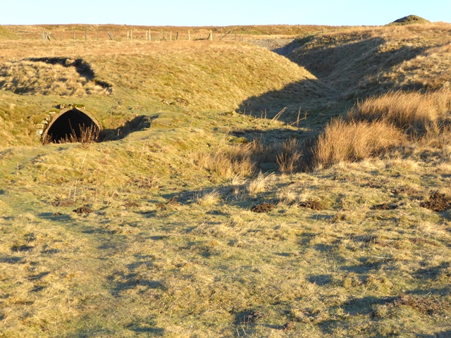
Partly drowned, partly on open fell. Old mine workings, shafts and spoil survive above the waterline around Cow Green and along the track to the dam, and have been photographed; the spoil heaps at Rod's Vein still contain fragments of the barytes that was mined there, with traces of galena among them. The ground is crossed by the North Pennines Geo Trail, and the mining features are among the things it is walked for.
Hushes, dams and old shafts from the early lead working, prominent in the landscape; spoil heaps at Rod's Vein still carrying barytes and traces of galena; a mine road with its spoil heap; and old shafts beside the track to the Cow Green dam. The main entrance level lies beneath the reservoir.
Related mines
- Gasswater Mine — Both were worked by the Hedworth Barium Company — Gasswater from 1917 and Cow Green in Teesdale — as the same firm developed barytes at opposite ends of the country.
- Potts Ghyll Mine — Two mines of the same second life: both worked veins that the lead miners had valued only for their galena, and both were worked later for the barytes that surrounded it, once a chemical and industrial market for barium sulphate existed where none had before.
Nearby mines
- Green Hurth Mine — 2.6 miles (4.3 km) NW
- Lady's Rake Mine — 3.1 miles (5.1 km) N
- Crook Burn Mine — 3.9 miles (6.2 km) N, Cumbria
- Force Garth Quarry — 4.5 miles (7.2 km) E
- Closehouse Mine — 4.9 miles (7.9 km) SE
Straight-line distance, within 9 miles (15 km). Show on the map.
Recorded claims
Individual factual claims, each attached to the source(s) that support it below. Where sources disagree, both are kept.
- The 1914 List of Mines records Cow Green at Harwood Fell under the Hedworth Barium Co. Ltd., working barytes and lead ore, with 18 men employed underground. 1
- The veins were worked in the late 18th and early 19th centuries primarily for lead ore, which tended to occupy the centre of the vein surrounded by barytes; evidence of this early working survives as hushes, dams and old shafts prominent in the landscape. 2
- The West Cowgreen mines consist of two main veins, the Winter Hush Vein running north-south and the Green Hush Vein north-east to south-west, with smaller veins including the Angle Vein, all in faults which are offshoots to the south of the major Teesdale Fault. 2
- The Winter Hush Vein consists of a series of lenses of predominantly barytes with galena more abundant in the narrower sections, the lenses averaging about 100 m long and 3 m wide and the intermediate sections about 1.2 m; an 80 m bore through the vein towards its southern end penetrated the Whin Sill, within which the vein consists entirely of witherite. 2
- Rod's Vein was worked opencast in the Melmerby Scar Limestone with the main vein 1.1 to 1.8 m wide, and the adjacent shaft, sunk in 1949, entered the Whin Sill at 20 m depth where the vein became narrower. 2
- Barytes was not mined commercially in the North Pennine orefield until the later 19th century. 2
- Old mine workings, shafts and spoil survive around Cow Green and beside the track to the dam. 3
Photographs & further reading
A field account of the veins, their barytes lenses and the sugar limestone, walked and described by the Natural History Society of Northumbria — the clearest explanation found of why this ground was worth working twice over.
View sourceSources
- (primary) 1914 List of Mines under the Metalliferous Mines Act: Durham — Durham Mining Museum
- (secondary) The Geology of Cow Green — Natural History Society of Northumbria
- (observational) Old mine workings at Cow Green (photograph) — Geograph Britain and Ireland
Record created: 5 September 2026 · Last researched: 5 September 2026