 MineArchive
Crook Burn Mine
| Also known as | Crookburn Mine |
|---|---|
| Location | Crook Burn, near Garrigill, Alston Moor, Cumbria — 54.7089, -2.3451 (approximate) |
| Commodity | Lead |
| Type | Metal |
| Worked | By 1888–by 1902 |
| Maximum depth | Unknown. |
| Operators | Crook Burn Mining Company (1888–?) |
Overview
Crook Burn was a lead mine on Alston Moor, on the burn of that name a few miles east of Garrigill, worked in the 1880s by a company run from Newcastle. It appears in the statutory return of 1888 and has gone from the equivalent list by 1902, which brackets its working life at the late end even if it does not date its beginning. An old shaft beside the burn survives.
History
The 1888 List of Mines under the Metalliferous Mines Act — the return every non-coal mine was obliged to make — records Crook Burn among the lead ore, zinc ore and barytes mines of Cumberland. Its entry places the mine at Garrigill, Alston, working lead ore, under the Crook Burn Mining Company of 25 Westgate Road, Newcastle-on-Tyne.
The same company appears twice in that list. A second mine, Tees Side, at Alston, is returned under the identical name and Newcastle address, so the concern was working at least two mines on the moor in that year. It sits in the list among a crowd of small Alston Moor ventures of the same kind — Craig Green, Cross Fell, Dowgang, Dowpot Syke and Guttergill, Rotherup Fell, Threlkeld — many of them, like this one, run by companies formed for the purpose and named after the ground they worked.
Crook Burn does not appear in the corresponding Cumberland metalliferous lists for 1902, 1914, 1921 or 1930. The mine had therefore stopped returning by 1902 at the latest, which is the fate of most of the small Alston Moor lead ventures of the 1880s: the price of lead collapsed against cheap imports through that decade and the next, and the ground was not rich enough to carry them through it. Nothing on record says when Crook Burn was begun, how many men it employed, or how much ore it raised.
Geology
Alston Moor holds some of the largest lead and zinc deposits in Britain, in the mineralised block of Carboniferous limestones, sandstones and shales of the North Pennine orefield. The ore occurs in near-vertical veins running along fractures in that sequence, richest where they cut a competent limestone or sandstone bed and pinching in the shales between — the pattern that gives North Pennine mines their characteristic string of workings following a vein across the fell. No source names the vein Crook Burn was working, and the mine's own geology is not established beyond the district's.
Geological setting: Veins and Lodes (historical documentary reference)
Workings
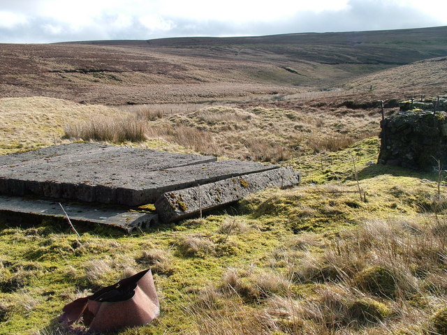
Unknown. A photograph taken in March 2007 records an old shaft beside Crook Burn itself, which fixes the position of at least one working; nothing on record describes levels, a dressing floor or the extent of the ground. The mine's name, like most on this moor, is the burn's.
Closure
No closure date is recorded. The mine was returning in 1888 and does not appear in the Cumberland metalliferous list for 1902, nor in those for 1914, 1921 or 1930, so it had ceased to make a return at some point in that fourteen-year gap. That is the most this archive can honestly say: the intervening years' lists were not available to check, so the date cannot be narrowed further from this source.
What remains
An old shaft beside Crook Burn was photographed in March 2007 and survives as a feature on the open fell. Nothing else about the present state of the site has been established.
An old shaft by the burn, recorded photographically in 2007.
Nearby mines
- Green Hurth Mine — 1.4 miles (2.2 km) S, County Durham
- Lady's Rake Mine — 1.8 miles (2.8 km) E, County Durham
- Tynehead Mine — 3.0 miles (4.8 km) N
- Cow Green Mine — 3.9 miles (6.2 km) S, County Durham
- Cash Well Mine — 4.2 miles (6.8 km) W
Straight-line distance, within 9 miles (15 km). Show on the map.
Recorded claims
Individual factual claims, each attached to the source(s) that support it below. Where sources disagree, both are kept.
- The 1888 List of Mines under the Metalliferous Mines Act records Crook Burn at Garrigill, Alston, working lead ore, owned by the Crook Burn Mining Co. of 25 Westgate Road, Newcastle-on-Tyne. 1
- The same 1888 list returns a second mine, Tees Side at Alston, under the Crook Burn Mining Co. at the same Newcastle address. 1
- Crook Burn does not appear in the Cumberland metalliferous list of 1902, nor in those for 1914, 1921 or 1930, so it had ceased to make a return between 1888 and 1902. 1,2
- An old shaft beside Crook Burn was photographed in March 2007. 3
Photographs & further reading
The statutory return this record rests on, listing Crook Burn among the small Alston Moor lead ventures of the 1880s with its Newcastle owners.
View sourceSources
- (primary) 1888 List of Mines under the Metalliferous Mines Act: Lead Ore, Zinc Ore, and Barytes Mines in Cumberland — Mines Department, via the Durham Mining Museum
- (primary) 1902 List of Mines under the Metalliferous Mines Act: Cumberland — Durham Mining Museum
- (observational) Old Shaft by Crook Burn (photograph, March 2007) — Geograph Britain and Ireland
Record created: 4 September 2026 · Last researched: 5 September 2026