 MineArchive
Lady's Rake Mine
| Also known as | Lady Rake Mine |
|---|---|
| Location | Harwood, Upper Teesdale, County Durham — 54.7024, -2.3025 (approximate) |
| Commodity | Lead |
| Type | Metal |
| Worked | Developed from 1868; worked earlier–1909 |
| Maximum depth | No depth figure has yet been located. |
| Operators | London Lead Company (1868–1902), Teesdale Mining Company (?–1909) |
Overview
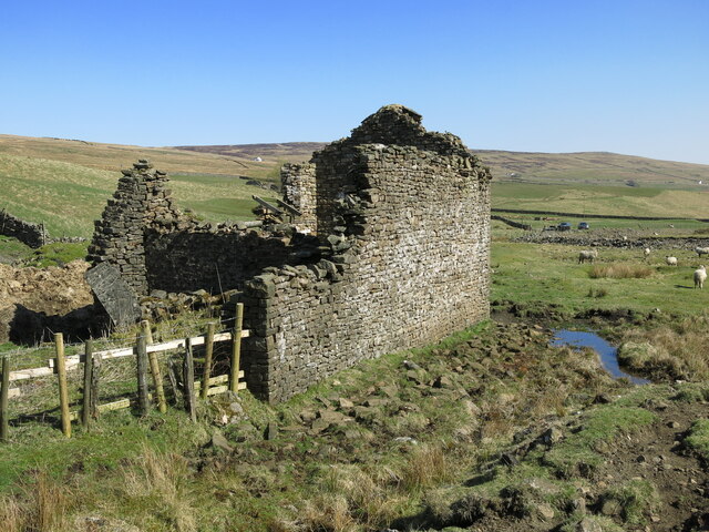
One of the last mines the London Lead Company opened, driven from 1868 on the vein of the same name above Harwood Beck in upper Teesdale. It kept a complete water-powered pumping and winding layout: a dam feeding a water-balance incline that raised the cage, and a waterwheel driving Cornish spear pumps whose iron rising main still stands in the shaft.
History
The Lady's Rake vein, running south-west to north-east, was known and worked before the London Lead Company took it up — a mine plan of 1828 shows two levels close to the site — but the mine as it survives was developed by the company from 1868, with Wigram's Level started in that year ahead of the shaft. It was among the last of the company's ventures: the London Lead Company, which had taken its first Teesdale lease in 1753 and moved its headquarters to Middleton in Teesdale in 1815, ceased operations in 1902. Lady's Rake outlived it, carried on first by a syndicate of local miners and then by the Teesdale Mining Company, until final closure in 1909.
Geology
The mine worked the Lady's Rake vein, a south-west to north-east lead vein in the Carboniferous rocks of upper Teesdale on the north side of Harwood Beck.
Workings
The surviving layout is a water-powered pumping and winding system. A grassed-over dam about 3 m high holds the reservoir at the north-east of the site; at its foot, beside the water release valve, is a stone and concrete machine base about 4 m by 2 m for the water-balance incline that raised material up the shaft. A wheeled water tank ran on rails down an incline south-west from the dam, joined by wire rope to the cage in the shaft: the cage assembly was the heavier, so at rest it sat at the shaft bottom with the tank at the top of the incline, and when the tank was filled from the reservoir it ran down and drew the cage up. At the foot of the slope a waterwheel drove a set of Cornish spear pumps to drain the workings; the brick and concrete settings and the iron holding-down bolts are in place, and the 0.3 m iron rising main protrudes about 2 m from the shaft with the pump spear still inside it. South of the shaft a levelled area of made ground, part of its revetment wall standing 2 m high, carries the earthworks of the pit head, and the collapsed entrance to Wigram's Level runs into the hillside 10 m east of the shaft. A second, rubble-filled shaft lies uphill south of the dam.
Closure
The London Lead Company wound up in 1902 but the mine was kept going by a syndicate of local miners and then by the Teesdale Mining Company until 1909; the mine databases list working until 1925 elsewhere on the Pike Law ground nearby, but not here.
What remains
The water-powered pumping and winding system is a scheduled monument and retains its complete layout. The dam, incline, machine settings, rising main and pump spear survive in place; the mine spoil heap to the south and the ancillary buildings to south and east are excluded from the scheduling as too disturbed, and the small mineshop — the miners' lodging house — has been converted to agricultural use.
The dam and reservoir, the water-balance incline and its rails, the machine bases with their iron fittings, the iron rising main and pump spear in the shaft, the revetted pit-head platform, the collapsed mouth of Wigram's Level, and a second filled shaft.
Redevelopment
None, beyond the conversion of the mineshop to farm use.
Related mines
- Pike Law Mine — Both are London Lead Company ground in upper Teesdale: the company held the Pike Law lease from 1753 and opened Lady's Rake in 1868, and the two lie about four kilometres apart on the same fell.
Nearby mines
- Crook Burn Mine — 2.8 km W, Cumbria
- Green Hurth Mine — 2.9 km SW
- Cow Green Mine — 5.1 km S
- Tynehead Mine — 6.3 km NW, Cumbria
- Sedling Rake Mine — 6.5 km NE
Straight-line distance, within 15 km. Show on the map.
Recorded claims
Individual factual claims, each attached to the source(s) that support it below. Where sources disagree, both are kept.
- Lady's Rake Mine was developed by the London Lead Company from 1868 to work the vein of the same name, though a mine plan of 1828 shows two levels close to the site. 1
- The London Lead Company ceased operations in 1902, but Lady's Rake continued in production until final closure in 1909, run first by a syndicate of local miners and then by the Teesdale Mining Company. 1
- A wheeled water tank running on an incline from the reservoir was connected by wire rope to the cage in the shaft, so that filling the tank drew the cage up — a water-balance winding system. 1
- A waterwheel at the foot of the slope powered a set of Cornish spear pumps, and the 0.3 m iron rising main still protrudes about 2 m from the shaft with its pump spear inside. 1
- The London Lead Company took its first Teesdale lease in 1753 and moved its headquarters to Middleton in Teesdale in 1815. 2
Photographs & further reading
A database record for the mine and its neighbours on the Teesdale fells, with the published literature on the Pike Law and Harwood workings.
View sourceSources
- (primary) Lady's Rake lead mine, Forest and Frith (List entry 1015834) — Historic England
- (secondary) London Lead Company — Wikipedia
Record created: 22 September 2026 · Last researched: 22 September 2026