 MineArchive
Pike Law Mine
| Also known as | Pike Law Hushes |
|---|---|
| Location | Newbiggin Common, between Teesdale and Weardale, County Durham — 54.6784, -2.1510 (approximate) |
| Commodity | Lead |
| Type | Metal |
| Worked | Antiquity; London Lead Company lease from 1753–1891; last worked 1925 |
| Maximum depth | No depth figure has yet been located; the veins were worked by hushing, shallow shafts and levels. |
| Operators | London Lead Company (1753–?), Thomas Wilson and Company (1859–1881), George and James Collinson (1882–1902), Teesdale Lead and Zinc Mines Ltd (1907–1912) |
Overview
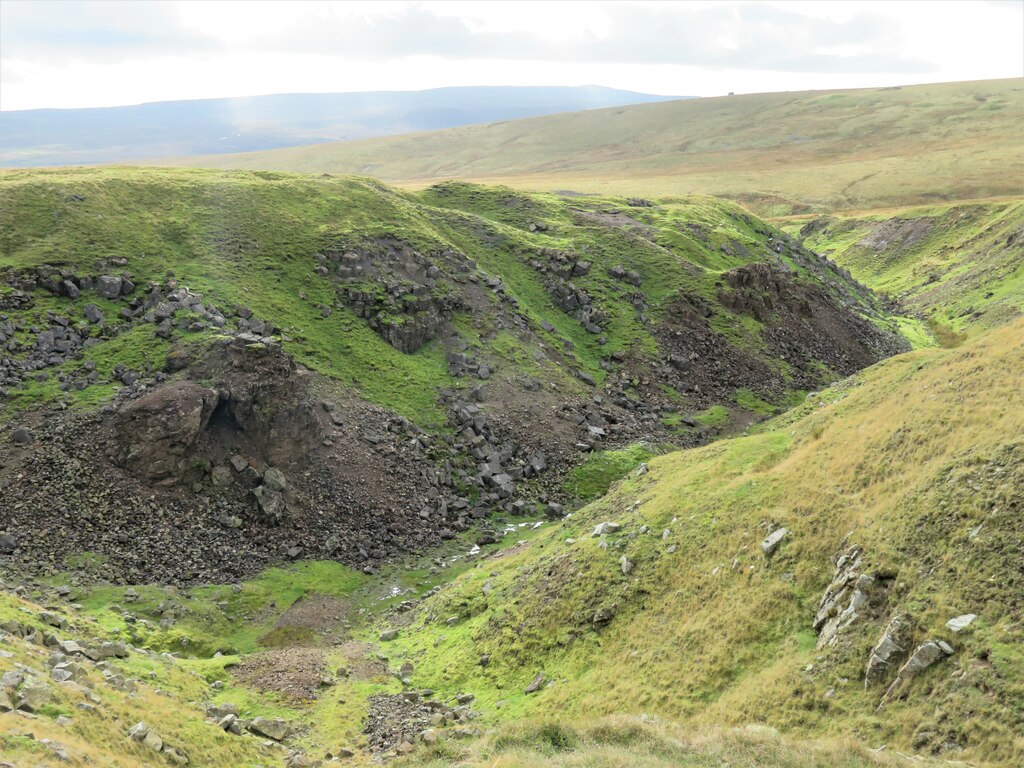
A lead-mining landscape on the watershed between Teesdale and Weardale, either side of the road from Newbiggin to Westgate, worked from early times and largely exhausted before 1852. Its three great hushes, fed by a network of dams and leats, and its hand-worked dressing floors make it one of the best preserved pre-19th-century lead mining landscapes in the northern Pennines.
History
The veins under Pike Law and Broadley Hill were worked from antiquity, and the ground was well established as a mine by 1753, when the lease was taken over by the London Lead Company. The company worked more than six veins running east–west and north-east to south-west across the fell between Wester and Flushiemere becks — Leonard's, Flask and Pike Law Old veins were opened by hushing, the Broadley Hill veins by shafts and by levels driven from the side of Leonard's Hush — and by about 1852 the mines were nearly exhausted. Small concerns went on picking over the ground for another generation: the mine databases list Thomas Wilson and Company from 1859 to 1881, George and James Collinson from 1882 to 1902, Jacob Scott and J. Hutchinson from 1903 to 1906 and Teesdale Lead and Zinc Mines Ltd from 1907 to 1912, but only 1,725 tons of ore were raised between 1852 and 1891, when all work is recorded as ceasing; a last working by R. W. Raine is listed in 1925. The barytes and fluorite in the veins were never worked, and the later Flushiemere barytes mine to the south-east is a separate site.
Geology
Pike Law sits on a dense concentration of mineralised veins and replacement deposits in the Carboniferous limestones of the Alston block, crossed by more than six east–west and north-east to south-west veins: the Westerhead, Tarn Streak, New Streak, Pike Law Old, Broadley Hill North and South, Leonard's and Flask veins. The veins were mined for lead and never for their fluorite, which remains in the dumps and at outcrop, and the site shows the effects of supergene alteration in situ and in the spoil.
Workings
Three main hushes run east–west on the east side of the road — Leonard's, Pike Law and Flask — each a gully 30 to 50 m wide and up to 10 m deep, fed by smaller side gullies and by leats from reservoirs behind earthwork dams up to 2 m high, with further dams in the gully bottoms. Their working faces stand exposed, their spoil heaps keep the inverted-V section of barrow tipping, and at least four levels are driven beneath them. West of the road the West End Hushes form opencuts more than 10 m deep where the Pike Law and Broadley Hill veins converge, with a fan of washed-out material half a hectare in extent below them. Shaft mounds 15 to 20 m across follow the New Streak and Broadley Hill veins, some with the traces of the cog-and-rung horse gins thought typical of 17th-century working. Two stone coes, a flagged and revetted floor, a stone-lined pit and scores of small bare patches of processing waste mark where ore was crushed and sorted by hand.
Closure
The ground was effectively exhausted by 1852. Only 1,725 tons came out between then and 1891, when all work is recorded as ceasing; the mine databases add a last working in 1925.
What remains
The core of the landscape is a scheduled monument. A volunteer condition survey for the North Pennines OREsome project in 2017 completed 72 assessment forms and recorded the main threats as weather, flooding, stream erosion and scrub growth, at low or low-to-medium risk overall. The exposed spoil supports nationally rare metal-tolerant lichens.
The three hushes and their dams and leats, the West End opencuts and prospecting hushes, shaft mounds with gin traces, two ruined coes, a flagged floor, a stone-lined pit, hand-dressing patches and a network of mine tracks.
Redevelopment
None. The site is open fell, crossed by the Newbiggin to Westgate road.
Related mines
- Lady's Rake Mine — Both are London Lead Company ground in upper Teesdale: the company held the Pike Law lease from 1753 and opened Lady's Rake in 1868, and the two lie about four kilometres apart on the same fell.
Nearby mines
- Force Garth Quarry — 4.4 km SW
- Coldberry Mine — 4.6 km SE
- Lodge Syke Mine — 5.3 km SE
- West Rigg Opencast — 5.6 km N
- Greenlaws Mine — 7.1 km N
Straight-line distance, within 15 km. Show on the map.
What's uncertain
Points where sources disagree or the record could not be settled; both accounts are kept. All open questions in the archive.
- Only 1,725 tons of ore were raised between 1852 and 1891, when all work finally ceased. (disputed) 1
- The mine is listed as worked until 1925, with R. W. Raine as the last operator. (disputed) 2
Recorded claims
Individual factual claims, each attached to the source(s) that support it below. Where sources disagree, both are kept.
- The area was worked from antiquity and was well established by 1753, when the lease was taken over by the London Lead Company. 1
- Only 1,725 tons of ore were raised between 1852 and 1891, when all work finally ceased. (disputed) 1
- The mine is listed as worked until 1925, with R. W. Raine as the last operator. (disputed) 2
- Thomas Wilson and Co. (1859–81), George and James Collinson (1882–1902), Jacob Scott and J. Hutchinson (1903–06) and Teesdale Lead and Zinc Mines Ltd (1907–12) are listed as the later operators. 2
- Three main hushes, Leonard's, Pike Law and Flask, each 30 to 50 m wide and up to 10 m deep, are fed by leats from reservoirs behind earthwork dams up to 2 m high. 1
- A 2017 volunteer condition survey completed 72 assessment forms and rated the threats from weather, flooding, erosion and scrub as low or low-to-medium. 3
Photographs & further reading
The OREsome project page with its archaeological, botanical and geological survey reports for the site, and links to volunteers' photographs.
View sourceA database record naming the veins and the succession of operators from 1859 to 1925, with references to the Geological Survey's lead, zinc and fluorspar memoirs.
View sourceSources
- (primary) Pike Law lead hushes and mines, Forest and Frith (List entry 1015835) — Historic England
- (secondary) Pike Law (a) — Buddlepit Mine Database
- (observational) Pike Law mine sites (OREsome project) — North Pennines National Landscape
Record created: 22 September 2026 · Last researched: 22 September 2026