 MineArchive
Coldberry Mine
| Also known as | Coldberry Lead Mine, Coldberry Mines |
|---|---|
| Location | Hudeshope valley, Hardberry Hill, near Middleton-in-Teesdale, County Durham — 54.6558, -2.0917 (approximate) |
| Commodity | Lead |
| Type | Metal |
| Worked | By the mid-18th century–1953–1956 (sources differ) |
| Maximum depth | Unknown. |
| Operators | London Lead Company (1861–1902), Teesdale Lead and Zinc Mines Ltd (1906–1910), R. W. Raine (1911–1920), New London Lead Co. Ltd (1925–1933), English Lead Mines Exploration Ltd (1937–1940), Coldberry Lead Co. Ltd (1952–1956) |
Overview
A lead mine high on the moor between the Hudeshope and Bow Lee becks, about 3 km north-north-west of Middleton-in-Teesdale, at the east end of Coldberry Gutter, the great gorge through Hardberry Hill that is reckoned the largest and most dramatic hush in the North Pennines. The surviving buildings were largely put up by the London Lead Company in the mid-19th century, and after a long run of small, intermittent working the mine closed in the 1950s. The whole complex is a scheduled monument.
History
The early history of the lead workings at Coldberry is uncertain, but Historic England records that more than two million tons of material had been removed from the hush before the mid-18th century. Later the veins were worked through a network of levels, and in the 19th century dressing floors were built on artificial terraces. The London Lead Company built the mine buildings that survive, a lodging shop, stables, a table and smithy block and a powder store, in the mid-19th century; Buddlepit's operator list, drawn from Northern Mine Research Society records, has the company working the mine from 1861 to 1902, and the Durham Mining Museum lists it as owner in the 1890s. The mine was never large: the museum's returns show it standing idle in 1884 and 1894, five men in 1896 and three or four around 1900. After the London Lead Company it passed to Lord Barnard as lessor from 1903 to 1905, to Teesdale Lead and Zinc Mines Limited from 1906 to 1910 and to R. W. Raine from 1911 to 1920. It was worked again from 1925, with thirteen men in 1927, eleven of them underground, under the New London Lead Company in the 1930s, and was idle from 1933. English Lead Mines Exploration Limited took it from 1937 to 1940, and an oreshoot was worked from the late 1930s; the last operator was the Coldberry Lead Company from 1952. Historic England dates the end of working to 1953, Buddlepit to 1956, and Wikipedia to about 1955. Six deaths are recorded at the mine: two labourers in a fall of roof in January 1870, a miner in 1880 and another in 1886 in falls of ground, and two young ore dressers smothered when a refuse heap collapsed in February 1896.
Geology
The mine worked lead veins on Hardberry Hill, on the watershed between the Hudeshope and Newbiggin valleys; the BGS catalogue of abandoned mine plans names Hunt's Coldberry Vein, the Manorgill North Vein and the Lodgesike–Manorgill Vein among its workings. Coldberry Gutter cuts through mudstones and siltstones of the Stainmore Formation, which are not ore-bearing here, and has a bed of millerite-bearing clay ironstone nodules unique in the North Pennines. Durham University geologists have concluded that the gutter is a glacial meltwater channel which the miners used and only slightly enlarged, rather than a hush cut entirely by them.
Geological setting: Veins and Lodes (well documented example)
Workings
An extensive network of levels, among them the Slate Sill level with its corbelled arch portal, and at the west end of the gutter the Red Grooves levels and a stone-lined shaft. Ore was dressed on terraced floors with round buddles and timber settling tanks, and moved on a water balance incline, one of only two known in the North Pennines. Water for hushing and dressing came along a stone-lined leat from at least 1.25 km to the north into a system of dams and reservoirs, the largest being Hardberry Hill Pool (Coldberry Moss Reservoir), which released water west into the Red Grooves workings.
Closure
Working dwindled after the London Lead Company left in 1902, and by the 20th century the mine was worked only in short spells as lead prices allowed, by a handful of men. The last oreshoot was worked from the late 1930s; Historic England gives 1953 as the end, Buddlepit's operator list has the Coldberry Lead Company working it until 1956, and Wikipedia gives about 1955.
What remains
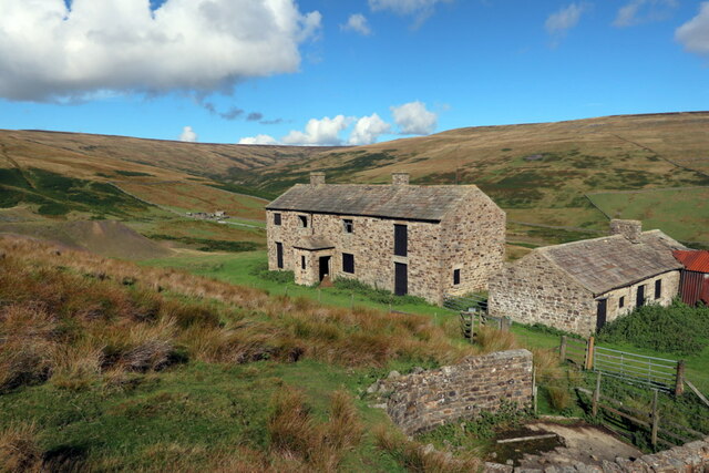
The mine, the Red Grooves hushes and ore works and the water system were scheduled as a monument in July 1997, and the lodging shop, stables, table and smithy block, level arch and powder store are Grade II listed. The lodging shop and stables stand roofed; a 2022 photograph shows them in good order on the open moor. The dressing floors were landscaped when the waste tips were removed for reprocessing, though 19th-century deposits survive below ground. The gutter is also a Durham County geological site.
The two-storey lodging shop, stables, table and smithy block, a level arch and retaining wall, a roofed powder store, 20th-century brick and concrete machine bases, the water balance incline, a round buddle and timber settling tanks, the Slate Sill level portal and mineshop, the Red Grooves level portals, shaft and a 40-metre bank of bouse teams, and the dams, reservoirs and leats.
Redevelopment
None: the mine is a scheduled monument, though the dressing-floor waste tips were removed for reprocessing.
Related mines
- Lodge Syke Mine — Both were London Lead Company mines in the Hudeshope valley, and BGS catalogues plans of the Lodgesike–Manorgill Vein as part of the Coldberry Mines.
Nearby mines
- Lodge Syke Mine — 1.2 km E
- Force Garth Quarry — 6.8 km W
- Cornish Hush Mine — 7.8 km NE
- Cambokeels Mine — 9.3 km N
- West Rigg Opencast — 9.4 km NW
Straight-line distance, within 15 km. Show on the map.
People
- R. W. Raine · proprietor, 1911–1920 — via the operator record
- George Redshaw · victim, 1880 — Miner, 17, killed on 18 February 1880 by a fall of roof while clearing debris after a shot.
- Henry Robinson · victim, 1886 — Miner, 27, crushed to death by a fall of ground on 14 January 1886.
What's uncertain
Points where sources disagree or the record could not be settled; both accounts are kept. All open questions in the archive.
- An oreshoot was worked between the late 1930s and 1953. (disputed) 1
- The Coldberry Lead Co. Ltd worked the mine until 1956. (disputed) 3
- Lead mining on Hardberry Hill continued until about 1955. (disputed) 5
Recorded claims
Individual factual claims, each attached to the source(s) that support it below. Where sources disagree, both are kept.
- More than two million tons of material had been removed from the Coldberry hush before the mid-18th century. 1
- The surviving mine buildings at the east end of Coldberry Gutter were built by the London Lead Company, largely in the mid-19th century. 1,2
- The London Lead Company worked the mine from 1861 to 1902, followed by Lord Barnard as lessor (1903–05), Teesdale Lead and Zinc Mines Ltd (1906–10), R. W. Raine (1911–20), English Lead Mines Exploration Ltd (1937–40) and the Coldberry Lead Co. Ltd (1952–56). 3
- The Durham Mining Museum lists the London Lead Co. as owner in the 1890s, R. W. Raine in the 1910s and the New London Lead Co. Ltd in the 1930s. 4
- The mine employed five in 1896, thirteen in 1927 (eleven underground) and had not been worked since 1933 by 1935. 4
- An oreshoot was worked between the late 1930s and 1953. (disputed) 1
- The Coldberry Lead Co. Ltd worked the mine until 1956. (disputed) 3
- Lead mining on Hardberry Hill continued until about 1955. (disputed) 5
- Coldberry Gutter is probably a glacial meltwater channel used and slightly enlarged by the miners, not a hush cut wholly by them. 5
- The mine's water balance incline is one of only two known in the North Pennines. 1,6
- Two ore dressers, Thomas Anderson (20) and William Coatsworth (15), were smothered by the fall of a refuse heap on 18 February 1896. 4
- Two labourers, John Beadle (18) and John Collinson (16), were crushed under a fall of roof on 20 January 1870. 4
- The mine and hushes were scheduled in July 1997 (list entry 1015863), and the principal buildings are Grade II listed. 1,5
Photographs & further reading
Historic England's list entry for the scheduled monument.
View sourceThe North Pennines National Landscape's OREsome project page on the gutter and the mine.
View sourceSources
- (primary) Coldberry lead mine and associated hushes (list entry 1015863) — Historic England scheduling text, reproduced by ancientmonuments.uk
- (observational) Mine Shop & Stables, Coldberry Lead Mine (photograph, 2022) — Geograph Britain and Ireland
- (secondary) Coldberry Mine — Buddlepit Mine Database (from Northern Mine Research Society records)
- (secondary) Coldberry (Lead Ore) — Durham Mining Museum
- (secondary) Coldberry Gutter — Wikipedia
- (observational) Coldberry Lead Mine, Teesdale — Outdoor Exploring Family
- (primary) BGS mine plans: Coldberry Mine, Middleton in Teesdale — British Geological Survey
Record created: 18 September 2026 · Last researched: 18 September 2026