 MineArchive
Potts Ghyll Mine
| Also known as | Potts Gill Mine |
|---|---|
| Location | Potts Gill, Caldbeck Fells, Cumbria — 54.7100, -3.0700 (approximate) |
| Commodity | Barite |
| Type | Metal |
| Worked | 1844–1940s |
| Maximum depth | Unknown. |
| Operators | J. H. Clay (1930–?) |
Overview
Potts Ghyll is one of the barytes mines of the Caldbeck Fells, on the north side of High Pike, where the barytes lodes run east to west across the fell cutting the older copper and lead veins the district is famous for. The mines here opened as early as 1844 and worked on and off until the 1940s, when demand for barytes as a war mineral made them briefly important. The 1930 List of Mines records nine men underground.
History
Barytes was for a long time worth nothing to a miner. Before the middle of the eighteenth century it was of little value to the mining companies and was thrown over the tips as waste along with calcite, quartz and the other gangue minerals. What changed was demand, not geology: barytes came to be wanted in quantity for the chemical, paint and paper trades and, later, as a shield against radioactivity and in drilling muds.
Caldbeck was one of the two main barytes-mining areas of the Lake District fells. The ground is a two-mile stretch of decomposed Borrowdale volcanic rock on the north side of High Pike, where the barytes lodes course east and west across the fell, cutting the many copper and lead veins for which the area is famous. Mining began in earnest in the nineteenth century, though the Elizabethan miners were doubtless aware of the heavy spar; the situation only really improved with the Great War.
The Potts Gill mines opened as early as 1844 and worked on and off until the 1940s, when prospects for the Caldbeck Fells were good and barytes mining took off in a big way. The 1930 List of Mines enters Potts Ghyll at Caldbeck under J. H. Clay of The Manor House, with nine men underground. East Potts Gill Mine commenced in 1942, and this essential war mineral for munitions was soon being produced there from the Back Vein, where the barytes formed a rib a full six feet in width.
The Caldbeck barytes industry outlived Potts Gill. The outcrop of Sandbeds East was discovered in 1927 though exploration and production did not follow until 1946, and Sandbeds West was not found until 1956; some 150,000 tons of dressed barytes came out of the Caldbeck mines altogether, and working ceased in 1966 when the Sandbeds mines closed. Lakeland's barytes industry as a whole ended in 1990, when Force Crag, the last working mine, was closed by a serious collapse in Zero Level.
Geology
The Caldbeck barytes ground is a two-mile area of decomposed Borrowdale volcanic rock on the north side of High Pike. The barytes lodes run east to west across the fell and cut across the copper and lead veins that made the Caldbeck Fells famous among mineral collectors — a cross-cutting relationship that dates the barytes as the later mineralisation. In the Caldbeck mines generally the veins varied from a few inches to twenty feet in width; at East Potts Gill the Back Vein carried a rib of barytes a full six feet wide. Barytes is barium sulphate, and its usefulness is chiefly its weight and its chemical inertness, which is why the same mineral that was once shovelled onto the tips became an industrial staple.
Geological setting: Veins and Lodes (well documented example)
Workings
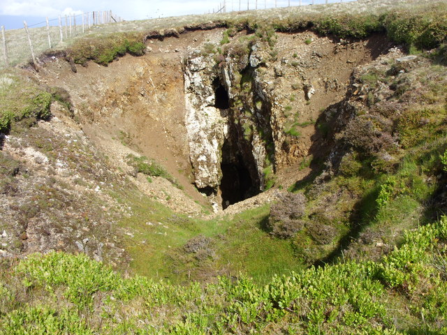
Underground working on the barytes lodes, with nine men below ground in the 1930 return. A separate working, East Potts Gill Mine, was begun in 1942 on the Back Vein. An exposed vein at the mine has been photographed. Nothing on record describes the levels, the dressing arrangements or how the mineral was taken off the fell.
Closure
The Potts Gill mines worked on and off from 1844 until the 1940s. The closure date for this working is not known; the Caldbeck barytes industry as a whole finished in 1966, when the Sandbeds mines closed.
What remains
Disused, with an exposed vein visible at the mine and photographed there. The Caldbeck Fells are open country and the mining ground is walked; nothing on record describes surviving buildings.
An exposed vein at the mine, and the workings on the fell. Nothing on record describes a surviving structure.
Related mines
- Cow Green Mine — Two mines of the same second life: both worked veins that the lead miners had valued only for their galena, and both were worked later for the barytes that surrounded it, once a chemical and industrial market for barium sulphate existed where none had before.
Nearby mines
- Deer Hills Baryte Mine — 0.5 miles (0.8 km) SE
- Roughton Gill Mine — 0.8 miles (1.4 km) SW
- Dry Gill Mine — 1.0 miles (1.6 km) SE
- Sandbed Mine — 1.0 miles (1.6 km) E
- Red Gill Mine — 1.2 miles (2.0 km) E
Straight-line distance, within 9 miles (15 km). Show on the map.
What's uncertain
Points where sources disagree or the record could not be settled; both accounts are kept. All open questions in the archive.
- The BGS mine-plans catalogue holds a Mining Remediation Authority abandonment plan titled 'Potts Ghyll' (catalogue OM15238, Unknown, undated in the catalogue); the catalogue gives no location and the plan's details do not clearly tie it to this working, so it may belong to another of the same name. (uncertain) 4
Recorded claims
Individual factual claims, each attached to the source(s) that support it below. Where sources disagree, both are kept.
- The 1930 List of Mines records Potts Ghyll at Caldbeck under J. H. Clay of The Manor House, with nine men employed underground. 1
- The Potts Gill mines opened as early as 1844 and worked on and off till the 1940s, when prospects were good for the Caldbeck Fells and barytes mining took off in a big way. 2
- East Potts Gill Mine commenced in 1942, and this essential war mineral for munitions was soon being produced from the Back Vein, where barytes formed a rib a full six feet in width. 2
- Caldbeck was one of the two main barytes mining areas of the Lake District fells, a two-mile area of decomposed Borrowdale volcanic rock on the north side of High Pike where the barytes lodes course east-west across the fell, cutting the many copper and lead veins for which the area is famous. 2
- Prior to the mid 18th century barytes was of little value to the mining companies and was thrown over the tips as waste along with calcite, quartz and other gangue minerals. 2
- Some 150,000 tons of dressed barytes were produced from the mines of Caldbeck, with operations ceasing in 1966 when the Sandbeds mines closed. 2
- A vein exposed at Potts Ghyll Mine has been photographed on the fell. 3
- The BGS mine-plans catalogue holds a Mining Remediation Authority abandonment plan titled 'Potts Ghyll' (catalogue OM15238, Unknown, undated in the catalogue); the catalogue gives no location and the plan's details do not clearly tie it to this working, so it may belong to another of the same name. (uncertain) 4
Photographs & further reading
The county-wide account of Lakeland barytes: how a waste mineral became an industry, which mines worked it, and how the Caldbeck and Force Crag operations rose and finished.
View sourceSources
- (primary) 1930 List of Mines under the Metalliferous Mines Act: Cumberland — Durham Mining Museum
- (secondary) Barytes — Industrial History of Cumbria
- (observational) Potts Ghyll Mine exposed vein (photograph) — Geograph Britain and Ireland
- (primary) BGS / Mining Remediation Authority mine plans: POTTS GHYLL — British Geological Survey / Mining Remediation Authority
Record created: 5 September 2026 · Last researched: 5 September 2026