 MineArchive
Sandbed Mine
| Also known as | Sandbeds Mine |
|---|---|
| Location | Driggith valley, Caldbeck Fells, Cumbria — 54.7080, -3.0450 (approximate) |
| Commodities | Lead, Copper, Zinc |
| Type | Metal |
| Worked | 18th century–1966 |
| Maximum depth | Unknown. |
Overview
A lead, zinc and copper mine in the Caldbeck Fells, working a continuation of the Roughton Gill South lode from the older, adjoining Driggith mine, whose own exhaustion shifted a succession of 18th- and 19th-century companies' attention onto Sandbed's own ground.
History
Sandbed Mine exploited a continuation of the Roughton Gill (South) lode reached from levels in the Driggith valley and from lower levels over the fell at Sandbeds itself, in the Caldbeck Fells, a lead-copper-baryte mining district in the northern Lake District worked from the arrival of German miners around 1564 through to the closure of the last barytes workings in 1966 -- a mining history spanning over 400 years. Low-temperature lead-zinc-copper veins developed within a NE-SW trending fracture system in the Eycott Volcanic Group rocks here produced ore that was predominantly galena, sphalerite and chalcopyrite in a gangue of quartz and barite; the close intergrowth of galena, sphalerite and barite, especially in the deeper levels, caused persistent problems for the gravity separators used to dress ore in the Victorian workings, and was a major factor in the mine's eventual failure. A succession of mining companies worked the lead veins here from the 18th century onward, the focus of activity shifting over time from the older, adjoining Driggith mine -- itself abandoned in the early 19th century after the cost of driving deeper levels proved too much -- onto Sandbed's own ground. Driggith was reopened for barytes in 1926, and the Sandbeds East outcrop, discovered the following year in 1927, was not itself explored and brought into production until 1946.
Geology
A continuation of the Roughton Gill (South) lode, reached from levels in the Driggith valley, carrying lead, zinc and copper.
Workings
Worked a continuation of the Roughton Gill South lode via levels in the Driggith valley and lower levels over the fell at Sandbeds; ore dressing was hampered throughout by the close intergrowth of galena, sphalerite and barite in the deeper levels.
Closure
Operations at the Sandbeds mines ceased in 1966, ending barytes mining on the Caldbeck Fells.
What remains
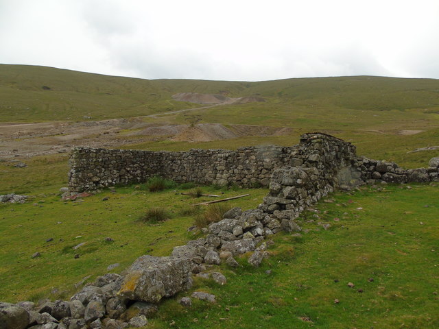
Bare, desolate ground in the Driggith valley with a sealed level, a pool at the site of the main level and the ruins of the mine buildings.
A sealed level, the site of the main level with a pool, and the ruined walls of the mine buildings.
Related mines
- Driggith Mine — Sandbed worked a continuation of the same Roughton Gill South lode as the older, adjoining Driggith mine, taking over as Driggith's own workings were exhausted.
Nearby mines
- Dry Gill Mine — 0.5 miles (0.8 km) SW
- Red Gill Mine — 0.5 miles (0.8 km) N
- Deer Hills Baryte Mine — 0.6 miles (1.0 km) W
- Brandy Gill Mine — 1.0 miles (1.6 km) S
- Potts Ghyll Mine — 1.0 miles (1.6 km) W
Straight-line distance, within 9 miles (15 km). Show on the map.
Recorded claims
Individual factual claims, each attached to the source(s) that support it below. Where sources disagree, both are kept.
- Sandbed worked a continuation of the Roughton Gill South lode reached from the older, adjoining Driggith mine; a succession of companies worked the lead veins here from the 18th century, activity shifting from Driggith -- abandoned in the early 19th century after the cost of deepening its levels proved too great -- onto Sandbed's own ground. 1
- The close intergrowth of galena, sphalerite and barite in the deeper levels caused persistent problems for Victorian gravity-separation ore-dressing and was a major cause of the mine's eventual failure; Driggith was reopened for barytes in 1926, and the Sandbeds East outcrop, discovered in 1927, was not brought into production until 1946. 2
- The outcrop of Sandbeds East was found in 1927 but not worked until 1946, and Sandbeds West, a continuation of its lodes, was found in 1956; the Caldbeck mines produced some 150,000 tons of dressed barytes, and operations ceased in 1966 with the closure of the Sandbeds mines. 3
- Photographs of 2011 and 2019 show a sealed level, the site of the main level with its pool, and the ruined former buildings of Sandbeds Mine. 4
Sources
- (secondary) Driggith Mine, Caldbeck — Old Cumbria Gazetteer
- (secondary) A review of the mineralisation at Driggith and Sandbed mines, Caldbeck Fells, Cumbria (abstract) — ResearchGate
- (secondary) Barytes — Industrial History of Cumbria
- (observational) Sealed mine level, site of main level and former buildings, Sandbeds Mine (Geograph, John Harrison 2011 and Ben Kendall 2019) — Geograph Britain and Ireland
Record created: 31 August 2026 · Last researched: 24 September 2026