 MineArchive
Botallack Mine
| Location | Botallack, near St Just, Cornwall — 50.1400, -5.6908 (approximate) |
|---|---|
| Commodities | Cobalt, Lead, Tin, Arsenic, Copper, Silver |
| Type | Metal |
| Worked | 1500s–1895 |
| Maximum depth | 250 fathoms (about 500 m) below sea level |
| Operators | Stephen Harvey James (1835–?) |
Overview
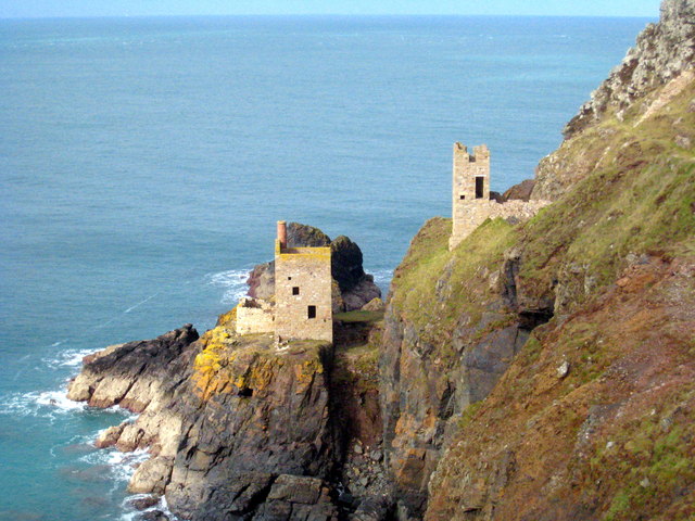
Botallack, its Crowns engine houses perched dramatically on the cliffs above the Atlantic, is one of the most photographed mining sites in Cornwall — and one of the most genuinely productive, with workings extending some 400 m out under the sea.
History
Documented mining at Botallack dates from the 1500s, when shafts were deliberately kept shallow to avoid the need to pump out seawater; the site may have been worked as early as the Roman or Bronze Age periods, though the evidence for this is unclear. The mine had a close call in 1835, when it was put up for sale and bought by the former Cornish wrestler Stephen Harvey James, who kept it running at a loss for two months — until a huge new copper lode was struck, yielding £44,000 profit and securing both his fortune and the mine's future; at its height under his ownership Botallack employed over 550 people, 340 of them underground. Over its working life from 1815 the mine produced roughly 14,500 tonnes of tin, 20,000 tonnes of copper and 1,500 tonnes of arsenic, alongside smaller quantities of cobalt, lead and silver; the mineral botallackite, a copper chloride, was named after its discovery here in the 19th century. The Boscawen Diagonal Shaft made Botallack a Victorian spectacle in its own right: Prince Arthur went down it in May 1862, the Prince and Princess of Wales in 1865 — in the same gig from which nine men and boys had fallen to their deaths two years earlier (see Disasters, below) — and the novelist R. M. Ballantyne in 1868, who drew on the visit for his Cornish mining novel Deep Down. The Crowns section was abandoned in 1874. Purpose-built arsenic-refining chambers — the “arsenic labyrinth” — were built in the 1900s to capture the poisonous fumes given off when calcining tin ore, drawing them through tunnels to a tall chimney stack.
Geology
Botallack worked tin, copper and arsenic-bearing lodes on the north coast near St Just, in the same hydrothermal orefield as neighbouring Levant, the lodes formed from fluids driven off the cooling Land's End granite and running out beneath the Atlantic. The mineral botallackite, a copper chloride, was first identified here.
Geological setting: Hydrothermal Deposits (well documented example), Veins and Lodes (well documented example)
Workings
Workings reached at least 250 fathoms (about 500 m) below sea level, with the Botallack engine-shaft alone reaching 220 fathoms; much of the deep ground lay out beneath the Atlantic. The mine's best-known work is the Boscawen Diagonal Shaft, begun in April 1858 and about four years in the sinking: driven at 32.5 degrees to the horizontal, roughly 6 ft high by 8 ft wide and some 400 fathoms long, it followed the lodes about two-thirds of a mile out under the sea to 250 fathoms below adit, at a cost of around £10,000. It cut the Crowns lode at the 190 fathom level, where the copper ground was reported two feet wide and worth £20 a fathom. Ore was processed and calcined on site, with arsenic fumes from the calciner drawn through the “arsenic labyrinth” flues to a chimney stack.
Closure
Botallack closed in 1895, beaten by falling tin and copper prices and by the cost of keeping seawater out of workings that ran far under the Atlantic. Brief attempts to reopen it followed between 1908 and 1912, ending in a second and final closure in March 1914. The site was worked over once more in 1985, when neighbouring Geevor erected a headframe here to extend its sett into the Botallack ground during a spike in the tin price — a venture killed within months by the October 1985 collapse of the International Tin Agreement.
What remains
The site is owned and managed by the National Trust, which acquired Botallack and the Crowns in 1997, and forms part of the Cornwall and West Devon Mining Landscape UNESCO World Heritage Site, inscribed in 2006. A January 2023 survey of Cornish headstocks recorded the 1985 headframe still standing.
Surviving structures include two engine houses in the cliffside Crowns section, repaired by the Carn Brea Mining Society in 1985, the remains of two further engine houses on the slopes above, the granite count house of 1861, and the arsenic refining works and labyrinth at the cliff top, now a scheduled monument. The steel headframe standing on the site is the youngest structure there — erected by Geevor in 1985, with five compartments.
Redevelopment
No major redevelopment has taken place; the site is preserved and open to visitors as a National Trust property and Scheduled Monument.
Related mines
- Wheal Cock — Wheal Cock was amalgamated into Botallack Mine after 1841.
- Wheal Edward — Neighbours on the Botallack cliffs; the Crowns section of Botallack lies immediately north of Wheal Edward.
Nearby mines
- Wheal Edward — 0.2 miles (0.4 km) NE
- Wheal Cock — 0.4 miles (0.7 km) N
- Wheal Owles — 0.4 miles (0.7 km) S
- Wheal Drea — 0.5 miles (0.8 km) S
- Boscean Mine — 0.7 miles (1.1 km) S
Straight-line distance, within 9 miles (15 km). Show on the map.
Disasters & major incidents
-
Botallack Mine shaft accident
18 April 1863 · Winding / Shaft Accident · 9 fatalities
The chain hauling a man-carriage up the Boscawen Diagonal Shaft broke; the carriage ran back out of control and struck timber at the bottom, killing all nine men and boys aboard.
What's uncertain
Points where sources disagree or the record could not be settled; both accounts are kept. All open questions in the archive.
- The mine is generally described as closing in 1895 on falling tin and copper prices; some secondary accounts instead describe operations continuing in reduced form to 1914. (disputed) 1
- Prince Arthur descended the Boscawen Diagonal Shaft on 15 May 1862 and the Prince and Princess of Wales in 1865, in the same gig involved in the 1863 accident; R. M. Ballantyne visited in 1868 and drew on it for his novel Deep Down. (uncertain) 3
- At its height under Stephen Harvey James's ownership the mine employed over 550 people, 340 of them underground. (uncertain) 2
Recorded claims
Individual factual claims, each attached to the source(s) that support it below. Where sources disagree, both are kept.
- The mine is generally described as closing in 1895 on falling tin and copper prices; some secondary accounts instead describe operations continuing in reduced form to 1914. (disputed) 1
- The mineral botallackite, a copper chloride, was first identified at Botallack in the 19th century and is named after the mine. 1
- In 1835 a huge new copper lode was discovered at Botallack within two months of the mine being bought by Stephen Harvey James, yielding £44,000 profit and rescuing the mine from closure. 1
- Botallack's Count House, completed in 1861, was where miners were paid under both the tutwork and tribute systems — tutworkers by the length of shaft or tunnel driven, tributers by bidding for a section of ground to work for a share of its ore value, at their own risk if the ground proved poor. 2
- The Boscawen Diagonal Shaft was begun in April 1858 and took about four years to sink: 32.5 degrees to the horizontal, roughly 6 ft by 8 ft, some 400 fathoms long, reaching 250 fathoms below adit about two-thirds of a mile out under the sea at a cost of around £10,000. 3
- Prince Arthur descended the Boscawen Diagonal Shaft on 15 May 1862 and the Prince and Princess of Wales in 1865, in the same gig involved in the 1863 accident; R. M. Ballantyne visited in 1868 and drew on it for his novel Deep Down. (uncertain) 3
- Botallack first closed in 1895 on low tin prices and the cost of draining seawater; after reopening attempts between 1908 and 1912 it closed finally in March 1914. 2
- At its height under Stephen Harvey James's ownership the mine employed over 550 people, 340 of them underground. (uncertain) 2
- The headframe standing at Botallack was erected by Geevor in 1985, with five compartments, to extend its sett into the Botallack ground; the venture failed after the October 1985 tin price collapse. 4
- The National Trust acquired Botallack Mine and the Crowns in 1997; the Crowns engine houses had been repaired by the Carn Brea Mining Society in 1985. 2
- BGS holds a scanned Botallack area lode map and base plan, alongside plans of the combined Geevor-Levant-Botallack group; Pendeen Community Heritage holds a transverse section along the line of the proposed Botallack inclined shaft. 5
Photographs & further reading
The site's owner and manager, with visiting information and further history of the Crowns engine houses.
View sourceCatalogue entry for the scanned lode map held by the British Geological Survey.
View sourceDetailed account of the Boscawen Diagonal Shaft and the mine’s Victorian celebrity.
View sourceFurther freely-licensed photographs of the clifftop engine houses.
View sourceSources
- (secondary) Botallack Mine — Wikipedia
- (secondary) The history of Botallack — National Trust
- (secondary) Botallack — Northern Mine Research Society — Northern Mine Research Society
- (observational) Deep Mine Headstocks, Part 2: Wales & Cornwall, 2022-23 — 28DaysLater
- (primary) BGS mine plans catalogue: Botallack area lode map (record 24038) — British Geological Survey
Record created: 19 August 2026 · Last researched: 25 August 2026