 MineArchive
Boscean Mine
| Location | Boscean, near St Just, Cornwall — 50.1303, -5.6884 (approximate) |
|---|---|
| Commodity | Tin |
| Type | Metal |
| Worked | By 1584 (mentioned by Norden)–c. 1873 (absorbed into Wheal Cunning United) |
| Maximum depth | 112 fathoms (slide shaft, 1856) |
| Operators | Wheal Cunning United (1873–?) |
Overview
A St Just tin mine on the west side of the Kenidjack valley, working unusual north–south lodes from a 112-fathom shaft in the 1850s, whose flooded workings were later blamed for the Wheal Owles disaster of 1893.
History
Boscean lies about 800 metres north-west of St Just, on the western side of the Nancherrow or Kenidjack valley. It was mentioned by John Norden in 1584, but little is known of it before the mid-19th century, when it was described as a large concern with more than seven steam engines. In 1851 it was taken on a 21-year lease at a royalty of 1/25, granted by the Grenville family, John Scobell, Lady Agar and others. Kelly's directory of 1856 describes a costbook company of 240 shares, with £20 10s paid on each, representing £4,920 of capital, its purser Samuel York of Penzance and its captains John Carthew, Richard Berryman and James Trezise; the mine had pumping engines of 36 and 40 inches, a 20-inch winding engine, and 48 heads of steam stamps and 19 of water stamps, and it produced 23 tons of tin ore in 1852, 91 tons in 1853 and 147 tons in 1854. Lord Falmouth was the landowner in 1864. Boscean, including Goldings Mine, worked until 1872, and by 1873 it was part of Wheal Cunning United with Boswedden, Wheal Castle and the reopened Wheal Cunning. Its workings were later abandoned and flooded. On 10 January 1893 miners at Wheal Owles broke through into the flooded workings next door, and nineteen men and a boy were drowned; accounts differ over whether the miners broke into Boscean's workings themselves or into Wheal Drea's, which Boscean's water had already filled.
Geology
The country rock is granite. The 1856 directory lists three lodes, the South, the Nennonick and Goulding's, crossed by the Wheal Owles Guide and Botallack Crowns cross-courses; a later account names the Pool, Rowe's, South and Great Boscean lodes, which unusually run north–south rather than north-west to south-east, and extend beneath the Botallack sett.
Geological setting: Veins and Lodes (well documented example)
Workings
In 1856 the mine was worked from a slide or tramroad shaft sunk 112 fathoms on the South lode, with levels at 40, 52, 64, 74, 86, 96 and 108 fathoms, and from Goulding's shaft, with levels from the 40 to the 86 fathom. Other shafts included Brown's, Coulson's and New. Its machinery then comprised two pumping engines, a winding engine and 67 heads of steam and water stamps.
Closure
Boscean worked on its own account until 1872 and by 1873 had been absorbed into Wheal Cunning United, a short-lived amalgamation. Its abandoned workings later filled with water.
What remains
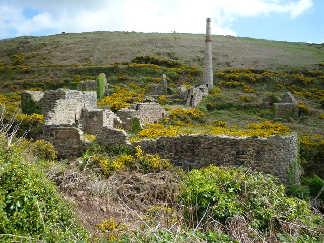
A 2013 photograph shows ruined stone mine buildings and a chimney at Boscean on a gorse-covered hillside. The remains of East Boscean are a prominent landmark on Nancherrow Hill.
Ruined stone buildings and a chimney at Boscean.
Related mines
- Wheal Drea — Boscean's water had flooded Wheal Drea's workings before the 1893 Wheal Owles breakthrough.
- Wheal Owles — Wheal Owles miners broke into flooded workings in 1893, water that the sources trace to Boscean.
Nearby mines
- Wheal Drea — 0.3 km N
- Wheal Hermon — 0.3 km S
- Wheal Owles — 0.4 km N
- Boswedden Mine — 0.5 km SW
- Botallack Mine — 1.1 km N
Straight-line distance, within 15 km. Show on the map.
Disasters & major incidents
-
Wheal Owles flooding disaster
10 January 1893 · Flooding / Inundation · 20 fatalities
Miners broke through into the flooded, long-abandoned workings of Wheal Drea, trapping and drowning twenty men and boys underground.
People
- Lady Agar · landowner, from 1851 — One of the grantors of the 1851 lease.
- Richard Berryman · agent, from 1856 — One of the mine's three captains in 1856.
- Richard Boyns · proprietor, from 1873 — via the operator record Wheal Cunning United
- John Carthew · agent, from 1856 — One of the mine's three captains in 1856.
- Charles Clemens · proprietor, from 1873 — via the operator record Wheal Cunning United
- William Hattam · proprietor, from 1873 — via the operator record Wheal Cunning United
- James Roach · proprietor, from 1873 — via the operator record Wheal Cunning United
- John Scobell · landowner, from 1851 — One of the grantors of the 1851 lease.
- James Trezise · agent, from 1856 — One of the mine's three captains in 1856.
- Samuel York · official, from 1856 — Purser of the mine in 1856, of Herbier House, Penzance.
What's uncertain
Points where sources disagree or the record could not be settled; both accounts are kept. All open questions in the archive.
- Cornwall Calling has the Wheal Owles miners breaking into flooded workings of Boscean Mine in 1893; Wikipedia has them breaking into the flooded workings of Wheal Drea, which had been flooded by water from Boscean. (disputed) 3,2
Recorded claims
Individual factual claims, each attached to the source(s) that support it below. Where sources disagree, both are kept.
- Boscean lies 800 m north-west of St Just on the western side of the Kenidjack valley; mentioned by John Norden in 1584, it worked (with Goldings Mine) between 1852 and 1872 and merged into Wheal Cunning United in 1873. 1
- The mine was held from 1851 on a 21-year lease at a royalty of 1/25, granted by the Grenville family, John Scobell, Lady Agar and others. 2
- In 1856 it was a costbook company of 240 shares with £4,920 paid up; the purser was Samuel York of Penzance and the captains John Carthew, Richard Berryman and James Trezise. 2
- The mine produced 23 tons of tin ore in 1852, 91 tons in 1853 and 147 tons in 1854. 2
- The slide shaft was sunk 112 fathoms on the South lode; the machinery comprised 36-inch and 40-inch pumping engines, a 20-inch winding engine and 67 heads of stamps. 2
- Boscean's lodes (Pool, Rowe's, South and Great Boscean) run north–south, unlike the usual north-west to south-east trend, and extend beneath the Botallack sett. 1
- In 1873 Wheal Cunning United included the former Boswedden and Wheal Castle, Wheal Cunning (reopened 1872) and Boscean. 2
- Cornwall Calling has the Wheal Owles miners breaking into flooded workings of Boscean Mine in 1893; Wikipedia has them breaking into the flooded workings of Wheal Drea, which had been flooded by water from Boscean. (disputed) 3,2
- The Mining Remediation Authority holds an abandonment plan of Boscean (OM666) in tin ore. 4
Photographs & further reading
Directory entries of 1856 and 1873 giving the mine's lease, lodes, shafts, engines, output and officers.
View sourceSources
- (secondary) Boscean (Buddlepit mine database) — Buddlepit
- (secondary) Boscean Mine, Cornwall — Cornwall Calling
- (secondary) Wheal Owles — Wikipedia
- (primary) Boscean (abandonment plan OM666) — British Geological Survey / Mining Remediation Authority
- (observational) Ruins of mining buildings, Boscean (photograph, 2013) — Geograph (Maurice D Budden)
Record created: 18 September 2026 · Last researched: 18 September 2026