 MineArchive
Wheal Edward
| Location | Botallack, St Just, Cornwall — 50.1420, -5.6870 (approximate) |
|---|---|
| Commodities | Copper, Tin, Uranium |
| Type | Metal |
| Worked | From 1821–1893 |
| Operators | Geevor Tin Mines Ltd |
Overview
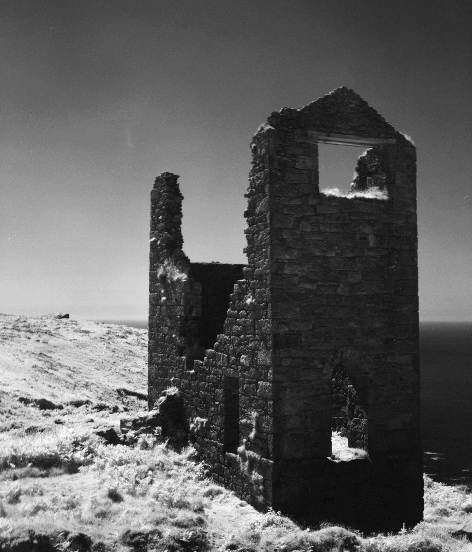
Wheal Edward, on the cliffs at Botallack beside West Wheal Owles, worked copper and tin from an incline shaft running out under the sea — and, decades after closing, gave up a mineral nobody was originally looking for: pitchblende, some of it sent to Marie Curie herself, and later mined in earnest for uranium by the Atomic Energy Authority.
History
Wheal Edward worked copper and tin lodes on the cliffs at Botallack from an incline shaft extending out under the sea, driven through notably hard greenstone bedrock. The ground was in tin bounds by 1776, when Elisabeth Usticke of Penzance granted a sett on Wheal Edward Bounds in Kenidjack to Richard Oats, tinner of St Just, at one-fifteenth toll. First returns date from 1821, and the mine was reopened in 1863; between 1821 and 1856 it produced only 2 tons of black tin but 955 tons of 9% copper ore. An engine house built around 1870 housed a rotating beam engine that drove the Wheal Edward stamps, crushing ore with 32 heads by the 1880s. In 1893, following the flooding disaster at the neighbouring West Wheal Owles, Wheal Edward was closed too — its workings were directly linked underground to Wheal Owles and the flooded Wheal Drea, and could not safely continue once that inundation occurred (see Disasters, below). The site's mineral specimens later proved unexpectedly significant: pitchblende from Wheal Edward was sent to Marie Curie, and between 1957 and 1959 the Atomic Energy Authority extracted 19 tons of uraniferous ore from the Wheal Edward cliff lode. Uranium was known on the lode long before the Atomic Energy Authority came: at the Wheal Owles adventurers' meeting of May 1870 the purser reported oxide of uranium found on the Wheal Edward lode and five hundredweight already sold, and William Jory Henwood had recorded uranite there some forty years earlier. The Wheal Edward ground later passed to Geevor Tin Mines, whose exploration of the cliff and undersea sections of West Wheal Owles and Wheal Edward is recorded in plans held by the British Geological Survey.
Geology
The mine worked copper and tin lodes within the St Just mining district of west Cornwall, part of the same hydrothermal, granite-related Cornubian orefield worked across Penwith; the same lodes also carried pitchblende, an unusual secondary mineralisation for the district.
Geological setting: Hydrothermal Deposits (well documented example), Veins and Lodes (well documented example)
Workings
An incline shaft extended the workings out under the sea through hard greenstone bedrock; an engine house built around 1870 housed a rotating beam engine driving the Wheal Edward stamps, which crushed ore with 32 heads by the 1880s.
Closure
The mine closed in 1893 after the flooding disaster at the neighbouring West Wheal Owles, to which its own workings were directly linked underground.
What remains
The engine house and associated mine remains survive on the cliffs at Botallack, within a few metres of the West Wheal Owles engine house.
Related mines
- Botallack Mine — Neighbours on the Botallack cliffs; the Crowns section of Botallack lies immediately north of Wheal Edward.
- Geevor Tin Mine — Geevor Tin Mines later owned Wheal Edward and explored its cliff and undersea sections.
- Wheal Drea — Wheal Edward's workings were directly linked underground to the flooded Wheal Drea, forcing its own 1893 closure.
- Wheal Owles — Wheal Edward's workings were directly linked underground to Wheal Owles and closed in the wake of the 1893 disaster.
Nearby mines
- Botallack Mine — 0.2 miles (0.4 km) SW
- Wheal Cock — 0.4 miles (0.6 km) NW
- Higher Levant Mine — 0.5 miles (0.8 km) NE
- Wheal Owles — 0.5 miles (0.9 km) S
- Wheal Drea — 0.6 miles (1.0 km) S
Straight-line distance, within 9 miles (15 km). Show on the map.
Disasters & major incidents
-
Wheal Owles flooding disaster
10 January 1893 · Flooding / Inundation · 20 fatalities
Miners broke through into the flooded, long-abandoned workings of Wheal Drea, trapping and drowning twenty men and boys underground.
Recorded claims
Individual factual claims, each attached to the source(s) that support it below. Where sources disagree, both are kept.
- Between 1821 and 1856 the mine produced only 2 tons of black tin but 955 tons of 9% copper ore; by the 1880s its stamps were crushing ore with 32 heads. 1,2
- Pitchblende from Wheal Edward was sent to Marie Curie, and between 1957 and 1959 the Atomic Energy Authority extracted 19 tons of uraniferous ore from the Wheal Edward cliff lode. 1
- At a Wheal Owles adventurers' meeting in May 1870 the purser, Mr Boyns, reported the discovery of oxide of uranium on the Wheal Edward lode and said he had already sold five hundredweight at 3s 3d a pound; a correspondent added that William Jory Henwood had found phosphate of uranium on Great Wheal Edward lode, in the seaward part of Wheal Owles, during the former working about forty years earlier. 3
- On 9 August 1776 Elisabeth Usticke of Penzance, sole owner for life of a pair of tin bounds called Wheal Edward Bounds in the tenement of Kenidjack, granted a sett to Richard Oats, tinner of St Just, and partner at one-fifteenth toll. The mine had two engine houses with 30-inch engines, heavy pumping being unnecessary, and two inclined shafts on a gradient of 1 in 3; it was eventually owned by Geevor Tin Mines. 4
- The British Geological Survey's catalogue holds a Wheal Owles plan and section of Wheal Edward (MP24783), longitudinal sections of the Wheal Edward cliff and lode dated 1879 (MP24803, MP24826), a plan of the undersea development at Wheal Edward Zawn (MP24786), and Geevor Tin Mines Ltd's plans of its exploration of the cliff and undersea sections of West Wheal Owles and Wheal Edward (MP24119, MP24563). 5,6
Sources
- (secondary) Wheal Edward, Botallack, St Just, Cornwall, England, UK — Albion Fire and Ice
- (primary) Wheal Edward - Northern Mine Research Society — Northern Mine Research Society
- (secondary) Wheal Edward (Graces Guide, quoting the West Briton, 26 May 1870) — Grace's Guide to British Industrial History
- (secondary) Wheal Edward Mine, Cornwall (Cornwall Calling) — Cornwall Calling
- (primary) Vertical Longitudinal Section Wheal Drea & Wheal Edward (BGS Mine Plans Catalogue) — British Geological Survey / Pendeen Community Heritage
- (primary) Mine plans: Wheal Owles plan of Wheal Edward section (MP24783); Geevor Tin Mines Ltd exploration of the cliff and undersea sections of West Wheal Owles and Wheal Edward (MP24119, MP24563); sections of Wheal Edward cliff and lode 1879 (MP24803, MP24826) (BGS Mine Plans catalogue) — British Geological Survey
Record created: 23 August 2026 · Last researched: 24 September 2026