 MineArchive
Tyndrum Mines
| Location | Tyndrum, Strathfillan, Stirling — 56.4362, -4.7272 (exact) |
|---|---|
| Commodities | Lead, Silver, Zinc |
| Type | Metal |
| Worked | 1741 (vein discovered)–1926 |
| Operators | Sir Robert Clifton (1741–1747), Company of Mine Adventurers (1747–1760), Scots Mining Company (1768–1791), John Campbell, Marquess of Breadalbane (1837–1862), Tyndrum Lead & Zinc Mines Ltd (1918–1926) |
Overview
The lead veins running up the hillside south of Tyndrum were found by accident in 1741 by an English baronet prospecting the wrong estate, and went on to be worked, on and off, by six different companies over nearly two centuries — long enough that the mine's spoil heaps are now as much a part of the village's identity as the peaks around it.
History
The Tyndrum veins were discovered accidentally in 1741 by Sir Robert Clifton, a Nottinghamshire baronet who had leased mining rights on the Breadalbane estate in 1730; between 1741 and 1745 his operation raised 1,697 tons of lead ore. The mine passed through a long succession of operators after Clifton's initial venture: the Mine Adventurers of England from 1747 to 1760, the Scots Mining Company from 1768 to 1791, the Caledonia Mining Company from 1803 to 1807, the Earl of Breadalbane's own direct management from 1837 to 1862, and finally Tyndrum Lead & Zinc Mines Ltd from 1918 to 1926. Ten levels were driven into the Hard Vein on the northern slope of Stron nan Colan, with parts of the vein also worked by opencast. Across its full working life, from 1741 to 1925, the Tyndrum Main Mine produced thousands of tons of lead and zinc ore along with around 760 ounces of silver.
Geology
The mine worked lead- and zinc-bearing veins, principally the Hard Vein, within the Grampian orefield of the Southern Highlands, a hydrothermal mineralised belt distinct from the granite-related lodes of Cornwall.
Geological setting: Hydrothermal Deposits (well documented example), Veins and Lodes (well documented example)
Workings
Ten levels were driven into the Hard Vein on the northern slope of Stron nan Colan, with sections of the vein also worked by opencast; a former lead-smelting site and the remains of an ore-crushing plant survive near the village.
Closure
The mine closed for the final time in 1926 after Tyndrum Lead & Zinc Mines Ltd's brief 1918-1926 revival failed to sustain operations.
What remains
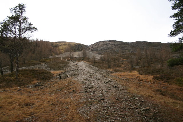
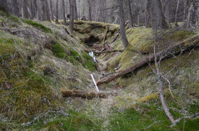
Spoil heaps, a collapsed adit and fenced shafts on the slopes of Sron nan Colan, with the site of the crushing plant beside the village.
Extensive spoil heaps, a collapsed adit, fenced-off shafts, and the remains of the former lead-crushing plant and smelting site all survive around the village and are a prominent local landmark.
Related mines
- Tomnadashan Copper Mine — The same metallurgist, W. J. Henwood, managed the Earl of Breadalbane's interests at both mines.
Nearby mines
- Cononish Mine — 2.1 miles (3.4 km) SW
Straight-line distance, within 9 miles (15 km). Show on the map.
Recorded claims
Individual factual claims, each attached to the source(s) that support it below. Where sources disagree, both are kept.
- Sir Robert Clifton's initial operation raised 1,697 tons of lead ore between 1741 and 1745; across the mine's full working life to 1925 it produced thousands of tons of lead and zinc ore along with around 760 ounces of silver. 1,2
- Ten levels were driven into the Hard Vein on the northern slope of Stron nan Colan, with sections of the vein also worked by opencast. 1
- The British Geological Survey holds J. S. Grant Wilson's copy plan of the Tyndrum mines (SP1042, 1:540) showing McCallum's, Long, Bryan's, Stamp, McDougal's, Burn, New and Lubach's levels with their sumps, rises and crosscuts, and the Tyndrum Lead and Zinc Mines Ltd's own plan (SP1040, 1:600) of Nos. 2 to 5 levels, the old drift on the south slope of Mine Hill, the ponds, mill, offices, huts and tramways, with cross sections (SP1041). 3,4
- Stephen Moreton's monograph (British Mining 99) has the mines worked from 1730 to 1926 by Sir Robert Clifton to 1747, the Mine Adventurers of England to 1760, Yorkshire investors from 1760 to 1762, the Scots Mining Company from 1768 to 1791, the Caledonia Mining Company from 1803 to 1807, the Earl of Breadalbane from 1837 to 1862 and, from 1918 to 1926, Tyndrum Lead and Zinc Mines Ltd, a subsidiary of Kinta Tin Mines. 1
- The main adit on the hillside above the village had collapsed by 2013. 5
Sources
- (secondary) British Mining No 99 - The Lead Mines of Tyndrum — Northern Mine Research Society
- (secondary) Tyndrum lead mine, Tyndrum, Stirling, Scotland, UK — Mindat
- (primary) Plan of Tyndrum Mines (BGS Mine Plans Catalogue) — British Geological Survey
- (primary) The Tyndrum Lead and Zinc Mines Ltd: plan of levels, mill and offices, SP1040 (BGS mine plans catalogue) — British Geological Survey
- (observational) Collapsed adit, Tyndrum lead mine (Geograph, Ashley Dace, 2013) — Geograph Britain and Ireland
Record created: 22 August 2026 · Last researched: 24 September 2026