 MineArchive
Susanna Mine
| Location | Leadhills, South Lanarkshire — 55.4172, -3.7683 (approximate) |
|---|---|
| Commodity | Lead |
| Type | Metal |
| Worked | 16th century–1869 |
| Maximum depth | Unknown. |
| Operators | Leadhills Mining Company (1861–1869), Scots Mining Company |
Overview
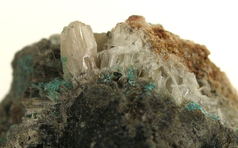
The richest vein in the Leadhills lead field and a mineralogical landmark in its own right — the type locality for six mineral species, including one, susannite, named directly after the mine.
History
Lead has been mined around Leadhills since 1239, under the Newbattle monks, but large-scale working began in the 1570s under Edinburgh goldsmith Thomas Foulis, who bought the land outright in 1592; it passed to the Hope family in 1638 through his granddaughter's marriage. By the 18th century around 40 veins were being worked across the district, with the Susanna Vein the richest of all — the Scots Mining Company, under manager James Stirling from 1734, made the operation genuinely profitable and expanded it into what contemporaries regarded as a technological wonder of 18th-century Scotland for its scale, machinery and investment. Mining declined from 1830 amid litigation over water rights, and though the Leadhills Mining Company took over in 1861, the Susanna Mine itself closed in 1869; mining continued intermittently elsewhere in the district into the early 20th century before the wider field finally closed in 1929.
Geology
The Susanna Vein cuts Southern Uplands greywacke and shale and is exceptional for its secondary mineralogy: Mindat records 35 mineral species from the site, six of them first described from Susanna Mine specimens — chenite, lanarkite, leadhillite, macphersonite, scotlandite and susannite, the last named directly after the mine itself.
Workings
Workings combined opencast cutting — the large spoil scar known as Lady Manners' Scar marks one such working — with underground shafts and levels, and surviving waterwheel pits show where water power drove pumping and processing machinery on site.
Closure
Mining declined from 1830 amid litigation over water rights; the Leadhills Mining Company took the ground over in 1861.
What remains
Open cast workings, shafts and waterwheel pits remain visible on the ground, though the extent of any public access is unclear — the Leadhills Estate, which owns the site, is the point of contact for current access information.
Lady Manners' Scar, open cast workings, mine shafts and waterwheel pits all survive above ground.
Related mines
- Leadhills — The Susanna Mine worked the richest vein in the Leadhills lead field.
Nearby mines
- Glengonnar — 0.2 miles (0.4 km) S
- Leadhills — 0.2 miles (0.4 km) E
- Cove Vein Mine — 1.3 miles (2.1 km) S, Dumfries and Galloway
- Wanlockhead — 1.4 miles (2.3 km) S, Dumfries and Galloway
- New Glencrieff Mine — 1.5 miles (2.4 km) S, Dumfries and Galloway
Straight-line distance, within 9 miles (15 km). Show on the map.
Recorded claims
Individual factual claims, each attached to the source(s) that support it below. Where sources disagree, both are kept.
- Susanna Mine is the type locality for six mineral species first described from specimens found there: chenite, lanarkite, leadhillite, macphersonite, scotlandite and susannite. 1
- The British Geological Survey holds a plan and section of the Susanna vein (SP11, 1:480) showing the Susanna and Portobello veins, the High Level mouth, Whitfield's, Harrison's and March shafts, McMorran's and Whitfield's drifts, Hadie's String and the Heslop's, Thompson's, Pop, Balance, March, Brown's, 10-fathom and 12-fathom sumps, with a section of about 1750 showing Pearson's Shaft; eighteenth-century sections of the vein (SP1787) and a sketch of the condition of Gripps Level in the Humby vein on the approach to the mine (SP1846) came from Lowland Lead Mines Ltd, and all can be viewed online. 2,3,4
- The Scots Mining Company's lease was renewed in 1730; James Stirling, manager from 1734 with the second Earl of Hopetoun's support, made the mines profitable, encouraged the miners to found the Leadhills Miners' Library in 1741, and on his death in 1770 the company put up the Curfew Bell; twenty years of litigation with the Leadhills Mining Company over water rights for the hydraulic machinery ended with the main company giving up its lease in 1861. 5
- Susanna is the type locality of six minerals, chenite, lanarkite, leadhillite, macphersonite, scotlandite and susannite; the open cast, shafts and waterwheel pits survive, with the spoil heap called Lady Manners' Scar. 1
Photographs & further reading
The scanned plan, viewable online.
View sourceSources
- (secondary) Susanna Mine
- (primary) Susanna Mine Plans (BGS, e.g. SP11, SP1787, SP1846) — British Geological Survey
- (primary) Susanna Vein, Leadhills: eighteenth-century sections, SP1787 (BGS mine plans catalogue) — British Geological Survey
- (primary) Susanna approaches: Landale's Shaft and Gripps Level, SP1846 (BGS mine plans catalogue) — British Geological Survey
- (secondary) History of Leadhills — Leadhills Estate
Record created: 22 August 2026 · Last researched: 24 September 2026