 MineArchive
Glengonnar
| Location | near Leadhills, South Lanarkshire — 55.4139, -3.7683 (approximate) |
|---|---|
| Commodities | Lead, Gold, Silver |
| Type | Metal |
| Worked | 1239–1940 |
| Maximum depth | 230 fathoms (Glengonnar shaft) |
| Operators | Sir Bevis Bulmer (1592–?), James Hope (1615–?), Leadhills Silver-Lead Mining and Smelting Company (1876–1901) |
Overview
Glengonnar, in the valley immediately above Leadhills, has one of the longest continuous mining records in Scotland — worked for lead since at least the 13th century, and briefly, remarkably, for gold rich enough to strike royal coinage.
History
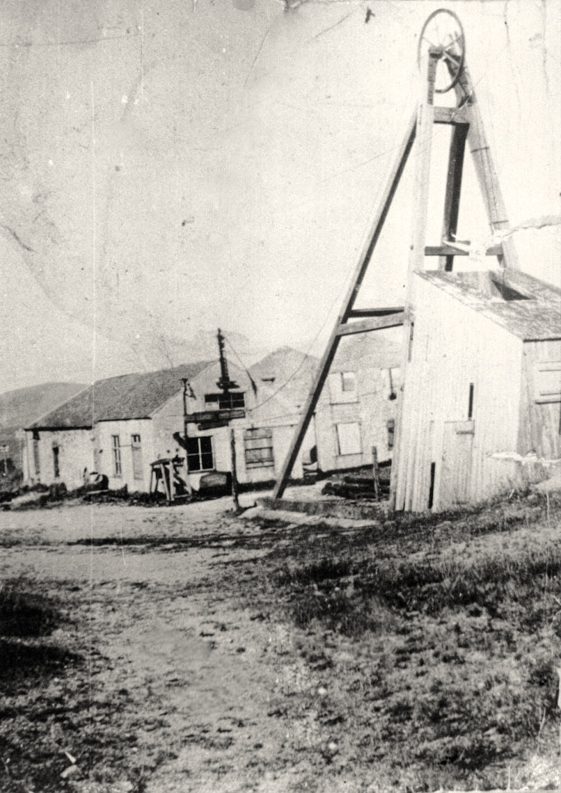
The first documented mining in the district is a lead mine at Glengonnar worked by the monks of Newbattle in 1239, though mining is thought to have gone on considerably longer before that. In the 16th century, during the reigns of James IV and James V, Glengonnar and the surrounding valleys became known for alluvial gold, worked on a large enough scale to leave conspicuous mounds of debris — locally called 'gowd scaurs' — still visible along the watercourses; the gold recovered was good enough to be struck into coins and crowns for the Scottish crown. By 1615, Robert Foulis of Edinburgh controlled the Glengonnar mines; his family's interests passed by marriage to James Hope, who went on to found the settlement of Leadhills and develop its lead mining on a larger scale. In the late 16th century Thomas Foulis took over the mines and partnered from 1592 with the English mining engineer Bevis Bulmer, who worked extensive operations on the Glengonnar. In 1876 an English syndicate paid £60,000 for the mining rights and floated the Leadhills Silver-Lead Mining and Smelting Company, working the Brown Vein from Wilson's Shaft and hoping to find a gold-bearing quartz vein substantial enough for large-scale gold mining for the first time in nearly three centuries; none was found, and persistent water problems continued to hamper the operation. In the early 20th century the Leadhills Company sank the Glengonnar shaft to 230 fathoms to work the Brown Vein, installing steam winding engines and its own 500-volt AC electric power generation; by 1901 the mine was raising 3,000 tons of ore a year, around 15 tons per man, and paying a 70% dividend. Operations wound down through the 1930s, and in 1940 all the mine's machinery was sold off.
Geology
The mine worked lead-bearing veins, and historically alluvial gold, within the Leadhills-Wanlockhead orefield of the Southern Uplands, one of Scotland's two major historic lead-mining districts.
Geological setting: Hydrothermal Deposits (well documented example), Placer Deposits (well documented example), Veins and Lodes (well documented example)
Workings
The Leadhills Company's Glengonnar shaft was sunk to 230 fathoms to work the Brown Vein, equipped with steam winding engines for the cages and its own 500-volt AC electric power plant — a substantial 20th-century investment for a mine already many centuries old by the time it was built.
Closure
Operations wound down through the 1930s, and in 1940 the mine's machinery was sold off, ending large-scale working at Glengonnar.
What remains
The site of Wilson's Shaft, worked by the Leadhills Silver-Lead Mining and Smelting Company from 1876, survives along with the route of an old tramway once connecting it to the Leadhills and Wanlockhead Railway.
Alluvial gold workings from the 16th-century gold rush survive as visible spoil mounds, or 'gowd scaurs', along the Glengonnar Water.
Related mines
- Leadhills — Glengonnar lies in the valley immediately above Leadhills, and the Leadhills Company itself sank Glengonnar's shaft.
Nearby mines
- Susanna Mine — 0.2 miles (0.4 km) N
- Leadhills — 0.3 miles (0.5 km) NE
- Cove Vein Mine — 1.1 miles (1.7 km) S, Dumfries and Galloway
- Wanlockhead — 1.2 miles (2.0 km) S, Dumfries and Galloway
- New Glencrieff Mine — 1.3 miles (2.1 km) S, Dumfries and Galloway
Straight-line distance, within 9 miles (15 km). Show on the map.
Recorded claims
Individual factual claims, each attached to the source(s) that support it below. Where sources disagree, both are kept.
- By 1901 the mine was raising 3,000 tons of ore a year, around 15 tons per man, and paying a 70% dividend. 1
- Gold recovered from the Glengonnar valleys in the 16th century was of good enough quality to be struck into coins and crowns for the Scottish crown. 1
- Glengonnar Shaft, at about 1,460 feet near the county boundary and the railway, is vertical to Brow Vein at 100 fathoms and then follows the vein to 249 fathoms; the workings in Brown's Vein run 500 fathoms and reach 160 fathoms below Gripps Level, the district's main adit, which passes the shaft at about 1,100 feet and falls two miles down the Glengonnar Water to its mouth near the old smelting mill. 2
- John Hedley's plan of the Earl of Hopetoun's lead mines at Leadhills, showing every vein of the district with its shafts on both sides of the Glengonnar Water, is held by the British Geological Survey (AP12706.32) and can be viewed online. 3
Photographs & further reading
The scanned plan of the Hopetoun lead mines on both sides of the Glengonnar Water, viewable online.
View sourceA local history of the Leadhills mines, their gold and their companies.
View sourceSources
- (secondary) Leadhills Mine History — Leadhills Mines (Kenneth Ledger)
- (primary) Lead and zinc ores of Scotland Area I. The Leadhills-Wanlockhead district — BGS Earthwise
- (primary) A PLAN OF THE LEAD MINES UPON THE ESTATE OF THE RIGHT HONOURABLE THE EARL OF HOPETOUN AT LEADHILLS COMPRISING A GENERAL (AP – Official Scottish non-coal abandonment mine and quarry AP12706.32, BGS mi — British Geological Survey / Mining Remediation Authority
- (primary) A Plan of the Lead Mines upon the Estate of the Right Honourable the Earl of Hopetoun at Leadhills (BGS Mine Plans Catalogue) — British Geological Survey / Health & Safety Executive
Record created: 22 August 2026 · Last researched: 24 September 2026