 MineArchive
Tilberthwaite
| Location | Little Langdale, near Coniston, Cumbria — 54.3993, -3.0815 (exact) |
|---|---|
| Commodities | Copper, Lead, Slate |
| Type | Metal |
| Worked | worked from the late 16th/early 17th century (Elizabethan)–1942 (copper) |
| Maximum depth | 550 feet (Deep Adit) |
| Operators | Barratt family (1850–1875), Greenburn and Tilberthwaite Mining Company (?–1942) |
Overview
Tilberthwaite, on the southern flanks of Wetherlam above Little Langdale, was worked as a mixed lead, copper and slate mine from Elizabethan times right through to the 21st century — its 1,039-yard Deep Adit alone taking the better part of a Victorian mining ambition to drive.
History
Tilberthwaite was worked by Elizabethan miners in the late 16th and early 17th centuries, with fragmentary records showing further working in the 18th century; it operated as a mixed lead, copper and slate mine from the late 16th century through to 1915. From the 1850s, and possibly earlier, until 1908 the mine was held by successive owners of the neighbouring Coniston Copper Mines: the Barratt family from 1850 to 1875, Thomas Wynn from 1875 to 1894, and Charles Day from 1894 to 1908. John Barratt drove the mine's major work, the Deep Adit, some 1,039 yards long, around 1850, working alongside the shallower Water Fall Level, 145 feet and 550 feet below the surface respectively. Later owners included the Central Chile Copper Company Ltd in 1912-13 and the Langdale Silver Lead and Copper Company Ltd in 1917, before copper operations finally ceased in 1942. The site's slate, quarried separately at Penny Rigg alongside the copper mill at the Deep Adit's mouth, proved workable for far longer: quality slate was discovered in the early 1930s and worked until about 1938, then reworked from 1989 until final closure in 2001.
Geology
The mine worked lead and copper mineralisation associated with the Coniston Fault, part of the same mineralised system that produced the neighbouring Coniston Copper Mines, alongside slate quarried from the district's Ordovician volcanic and sedimentary rocks.
Geological setting: Hydrothermal Deposits (well documented example), Slate and Regional Metamorphism (well documented example), Veins and Lodes (well documented example)
Workings
The Deep Adit, some 1,039 yards long, was driven by John Barratt around 1850 to work and drain the deeper lead and copper workings, reaching 550 feet below the surface, alongside the shallower Water Fall Level at 145 feet; the Penny Rigg copper mill stood at the adit's mouth, with slate quarried separately nearby.
Closure
Copper and lead operations finally ceased in 1942; slate quarrying at the site, worked intermittently through the 20th century, continued until final closure in 2001.
What remains
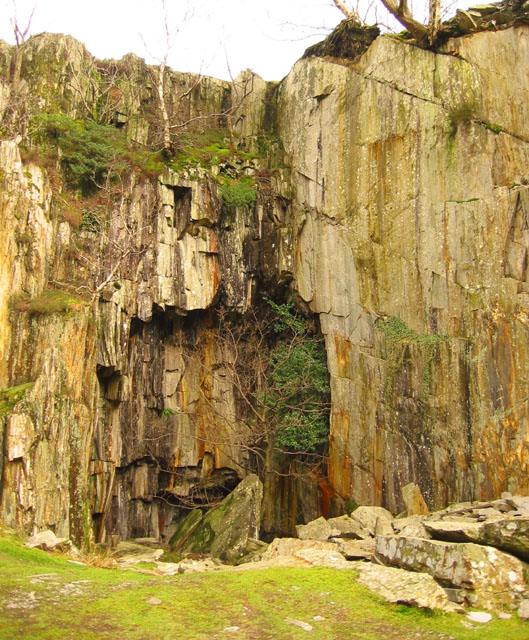
The Deep Adit still drains the old workings; the Penny Rigg mill remains stand at its mouth, two mine buildings survive by Tilberthwaite Beck, and the slate quarries lie disused.
The Deep Adit survives, still draining much of the old workings, along with the remains of the Penny Rigg copper mill at its mouth and the disused slate quarries in the gill above.
Related mines
- Coniston Copper Mines — Held by the same successive owners as Coniston from the 1850s to 1908: the Barratt family, then Thomas Wynn, then Charles Day.
- Greenburn Mine — Worked together by the Greenburn and Tilberthwaite Mining Company in the 1930s.
Nearby mines
- Greenburn Mine — 0.7 miles (1.1 km) NW
- Parrock Quarry — 1.1 miles (1.8 km) E
- Hodge Close Quarry — 1.2 miles (2.0 km) NE
- Coniston Copper Mines — 1.6 miles (2.6 km) S
- Cove Quarries, Coniston — 2.7 miles (4.4 km) SW
Straight-line distance, within 9 miles (15 km). Show on the map.
Culture
- Arthur Ransome's Pigeon Post and Tilberthwaite (Literature)
Ransome explored the Tilberthwaite workings in 1935 while writing Pigeon Post; Willie Shaw's slate mine in the Tilberthwaite tunnel, backed by Oscar Gnosspelius, gave the book Slater Bob and Squashy Hat.
Recorded claims
Individual factual claims, each attached to the source(s) that support it below. Where sources disagree, both are kept.
- The Deep Adit, some 1,039 yards long, was driven by John Barratt around 1850, reaching 550 feet below the surface, alongside the shallower Water Fall Level at 145 feet. 1,2
- Quality slate discovered at the site in the early 1930s was worked until about 1938, then reworked from 1989 until final closure in 2001. 2
- The National Trust's record describes an 800-foot-wide mining belt between the waterfall at the head of Tilberthwaite Gill and the old mine road, on seven east-west veins with five named lodes, North, Shaft, Benson's, Benson's South and Spedding's; the Greenburn and Tilberthwaite Mining Company cleaned out the Deep Adit in the 1930s, found nothing of value and was liquidated in 1942, and two buildings by Tilberthwaite Beck survive with a cut seam 300 metres long. 1
- The British Geological Survey holds, from the Cumbria Amenity Trust's collection, a plan of Tilberthwaite Mine before the Deep Level was driven, at a fathom to the inch (CT189), and a sketch of the mines when they belonged to A. Knott at eight feet to the inch (CT234), with other Tilberthwaite copper-mine plans and sections; both can be viewed online. 3,4
Photographs & further reading
A March 2022 visit to the deep level adit driven from 1849 by John Barret to drain the Tilberthwaite copper workings and bring ore out from the higher levels, and to the Penny Rigg copper mill built at its mouth. Notes that the adit runs over 3,000 feet and still drains much of the workings, and that in 1933 John Willie Shaw found it had cut through good slate about 300 feet in and worked that until 1938.
View sourceThe scanned plan, viewable online.
View sourceSources
- (secondary) Tilberthwaite Copper Mine (Water Fall Level), Coniston — National Trust Heritage Records
- (secondary) Tilberthwaite Mixed Mine — Buddlepit Mine Database
- (primary) Plan of Tilberthwaite Mine, CT189 (BGS mine plans catalogue, Cumbria Amenity Trust collection) — British Geological Survey
- (primary) A sketch of the Tilberthwaite mines belonging to A. Knott Esq, CT234 (BGS mine plans catalogue) — British Geological Survey
- (primary) TILBERTHWAITE mine plans — British Geological Survey / The Coal Authority
Record created: 24 August 2026 · Last researched: 24 September 2026