 MineArchive
Greenburn Mine
| Location | Greenburn Valley, near Coniston, Cumbria — 54.4062, -3.0930 (exact) |
|---|---|
| Commodity | Copper |
| Type | Metal |
| Worked | From late 17th century–c. 1885 |
| Maximum depth | Unknown. |
| Operators | Greenburn and Tilberthwaite Syndicate (1906–1909), Langdale Silver, Lead and Copper Company (1912–1917), Greenburn and Tilberthwaite Mining Company (1925–1940) |
Overview
Greenburn, tucked into its own valley west of Coniston, was worked for copper on and off from the late 17th century and became, in its mid-19th-century heyday, an outlier of the wider Coniston Copper Mines — before ending up, by an odd twist, in the care of Beatrix Potter's own estate.
History
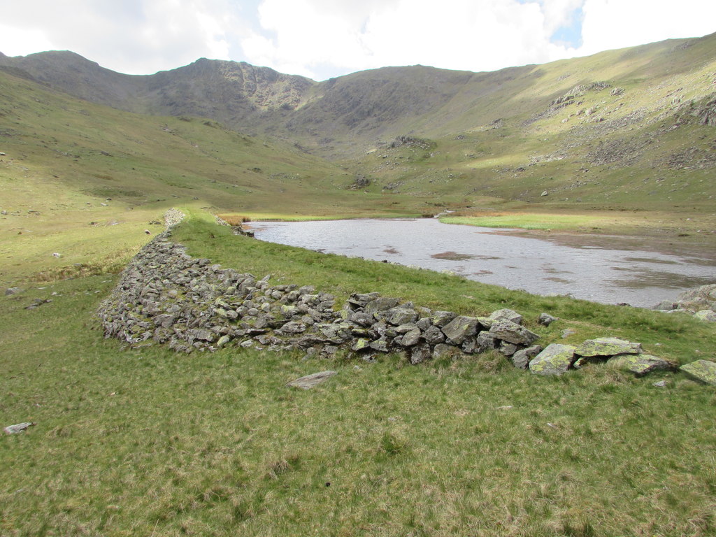
Documentary evidence shows a reasonably intense and prolonged period of copper mining at Greenburn by 1690, when it appears as a producer at a time when little else was being worked in the Coniston field; it was regarded as an outlier of the wider Coniston Copper Mines and known for parts of the 19th century as New Coniston Mine and Great Coniston Mine. It lies about 3 km west-south-west of Little Langdale, and until the county boundaries were redrawn in 1974 it was just inside Lancashire. Leases were offered for prospecting in the late 18th and early 19th centuries, though what was done under them is not recorded. The mine's most intensive period ran from around 1845 to 1861, including the sinking of an Engine Shaft, the driving of the Long Crag Level, and the construction of the Greenburn Reservoir to supply water power. A succession of companies worked the site less successfully until around 1885. In 1906 the Greenburn and Tilberthwaite Syndicate took the lease to mine the Pave York Vein, building an inclined tramway down from its Middle Level, but ran the work down within two or three years; the Langdale Silver, Lead and Copper Company then mined from 1912 for five years, and a Greenburn and Tilberthwaite Mining Company formed in the mid-1920s did little before it was dissolved in 1940, by which time mining activity had ceased entirely. The site formed part of the Pennington family estates until 1930, when the land was bought and bequeathed to the National Trust by Beatrix Heelis — the author and illustrator better known as Beatrix Potter.
Geology
The mine worked copper lodes within the Coniston orefield of the Lake District, associated with the Borrowdale Volcanic Group, part of a hydrothermal mineralised system distinct from the granite-related lodes of Cornwall and Devon. Five veins run roughly with the valley: from north to south the Low Gill, Sump, Gossan, Pave York and Long Crag Veins. The ore in four of them is chalcopyrite; the Pave York Vein carries cuprite, which needed different processing, latterly by acid precipitation.
Geological setting: Hydrothermal Deposits (well documented example), Veins and Lodes (well documented example)
Workings
The mine's main features include the Engine Shaft and the Long Crag Level, along with the Greenburn Reservoir, built to supply water power to the site during its 1845-61 intensive working period. It worked several veins: the Long Crag Vein, whose Upper Workings are three closely spaced levels high on Wetherlam with Long Crag Level some 90 metres below; the Pave York Vein, worked from Top, Middle and Bottom Levels and served by the 1906 tramway; the Gossan Vein, from a shaft and level lower down; and the Low Gill and Sump Veins near the valley floor, with their own shafts, trials and a level, plus the Greenburn Shaft and Greenburn Beck Level at the eastern end.
Closure
A succession of companies worked the site with declining success until around 1885, and mining had ceased entirely by 1940.
What remains
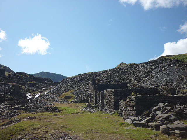
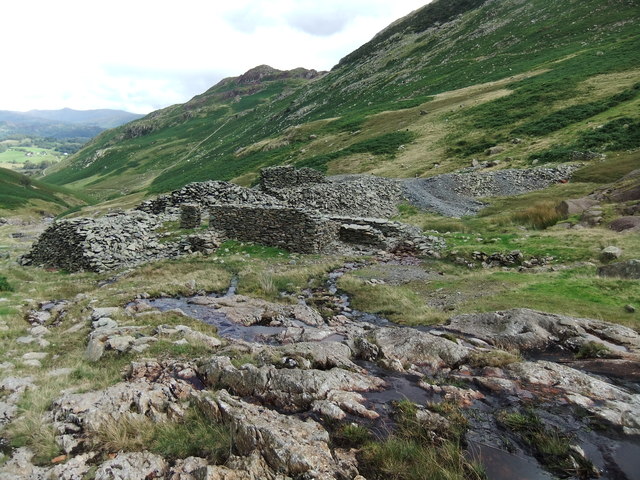
Ruined buildings, spoil heaps, the wheelpit and the reservoir dam were photographed in 2015-2019; the site has been a Scheduled Monument since 2003 and lies on National Trust land.
Extensive remains of the mine and its associated ore-processing works survive in the Greenburn Valley, protected as a Scheduled Monument within the Lake District National Park. The main processing area holds spalling floors, spoil tips, leats, an engine house and wheelpit, a crushing mill, crusher and stamp houses, a jigger house, buddle houses, a slime tank, two acid precipitation tanks, loading bays, an ore store, an explosives store and a range of workers' accommodation, office and smithy, with the Engine Shaft still holding a pump rod in place. Small blast shelters stand by several level mouths, and the dam of Greenburn Reservoir survives with spillways at each end.
Related mines
- Coniston Copper Mines — Greenburn was regarded as an outlier of Coniston and was known for parts of the 19th century as New Coniston Mine and Great Coniston Mine.
- Tilberthwaite — Worked together by the Greenburn and Tilberthwaite Mining Company in the 1930s.
Nearby mines
- Tilberthwaite — 0.7 miles (1.1 km) SE
- Parrock Quarry — 1.5 miles (2.4 km) E
- Hodge Close Quarry — 1.6 miles (2.5 km) E
- Coniston Copper Mines — 2.0 miles (3.2 km) S
- Lords Quarry — 2.7 miles (4.4 km) NE
Straight-line distance, within 9 miles (15 km). Show on the map.
Recorded claims
Individual factual claims, each attached to the source(s) that support it below. Where sources disagree, both are kept.
- Documentary sources show intensive mining under way at Greenburn by 1690; the most productive period ran from around 1845 to 1861, after which the site was worked with declining success until about 1885 and ceased entirely by 1940. 1,2
- The site passed into National Trust care in 1930 as a bequest from Beatrix Heelis (Beatrix Potter), having previously formed part of the Pennington family estates. 1
- In 1906 the Greenburn and Tilberthwaite Syndicate took the lease, mining the Pave York Vein and building an inclined tramway from the Middle Level, but ran the work down after two or three years; the Langdale Silver, Lead and Copper Company mined from 1912 for five years, and the Greenburn and Tilberthwaite Mining Company, formed in the mid-1920s, recorded little mining before it was dissolved in 1940. 3
- The main processing area preserves the remains of a grate house, crushers and stamps beside a wheelpit, a jigger house, round buddles and a slime tank, and two precipitation tanks in which sulphuric acid was used to precipitate copper from crushed copper-oxide ore. 3
- Greenburn in Little Langdale first appears as a copper producer in the later 17th century, when little else was being done in the Coniston field. 4
- Photographs of 2015-2019 show ruined buildings, spoil heaps and the waterwheel pit in the main processing area. 5,6
- Five copper veins run roughly along the Greenburn Valley, from north to south the Low Gill, Sump, Gossan, Pave York and Long Crag Veins; the ore in four of them is chalcopyrite and in the Pave York Vein cuprite, and different processing was applied to the two at different dates. 1
- English Heritage surveyed the surface remains between September and November 2000 at the National Trust's request, and the site was scheduled as an Ancient Monument in April 2003; before 1974 it lay just inside the northern border of Lancashire. 1,2
- Further extraction was carried out between 1906 and 1917, and there was an intermittent presence on the site between about 1924 and 1942 with minimal work done. 1
Photographs & further reading
The full Historic England scheduling description, walking through every level, shaft and processing building on the site.
View sourceAn overview of Lake District copper mining from the Mines Royal to the 20th century, placing Greenburn in the Coniston field.
View sourceSources
- (secondary) Greenburn Mine, Greenburn Valley, Coniston, South Lakeland, Cumbria, England, UK — Mindat
- (primary) Greenburn copper mines and associated ore processing works, Coniston — Historic England (Scheduled Monument record)
- (primary) Greenburn copper mines and associated ore processing works, Coniston (scheduling description) — Historic England, via AncientMonuments.uk
- (secondary) Copper | Industrial History of Cumbria — Cumbria Industrial History Society
- (observational) Greenburn copper mine (Geograph photo 4643724, David Brown, 2015) — Geograph Britain and Ireland
- (observational) Greenburn Mine site (Geograph photo 6180998, Trevor Littlewood, 2019) — Geograph Britain and Ireland
- (primary) Greenburn Mine, Coniston (BGS Mine Plans Catalogue) — British Geological Survey / Cumbria Amenity Trust Mining History Society
Record created: 23 August 2026 · Last researched: 18 September 2026