 MineArchive
Sipton Mine
| Location | Sparty Lea, Allendale, Northumberland — 54.8435, -2.2402 (approximate) |
|---|---|
| Commodities | Lead, Fluorspar |
| Type | Metal |
| Worked | 1850s (discovery)–1985 |
| Maximum depth | Unknown. |
| Operators | W. B. Lead Company (1902–1921), Weardale Lead Company (1923–1948) |
Overview
A Northumberland lead mine on the Blackett Level drainage system, worked from the 1860s and again from 1923-48, whose shaft housed the North Pennines' last hydraulic hoist engine.
History
Sipton Mine worked the Sipton Vein, about a kilometre north of St Peter's Mine at Sparty Lea in Allendale, near the confluence of the Sipton Burn and the River East Allen. The vein was discovered during the driving of the Blackett Level - a drainage tunnel being driven south from Allendale Town toward Allenheads to drain the lower levels of the Allenheads Mine. A shaft was sunk on the vein from the surface to aid the level's construction, the second of four sunk along its course; the vein was worked for galena during the early-to-mid 1860s, and the shaft also gave access to Esp's Vein, exposed along the Blackett Level just under a kilometre to the north.
Recorded company ownership begins with the W. B. Lead Co. Ltd from 1902 to 1921, and the Weardale Lead Co. Ltd from 1923 to 1948. In 1921 sixty-five people were employed here, forty-one of them below ground. The shaft itself remained in use until 1946, by then equipped with the last hydraulic hoist engine still operating anywhere in the North Pennine orefield. The mine supported its own workers' housing, Sipton Terrace, and a Wesleyan chapel built in 1862 at nearby Tedham, demolished before the First World War; most of the mine's own buildings came down in 1950.
Lead was not the end of it. The mine was reopened for fluorspar and was still working in 1985, four decades after the hoist engine stopped - a second life of the kind that kept a good many North Pennine workings going after the lead trade had gone, as the spar that had been gangue to the old miners became the thing worth raising. The covered shaft still connects to the Blackett Level, which runs to this day.
Geology
The Sipton Vein in East Allendale, about a kilometre north of St Peter's Mine at Sparty Lea, found during the driving of the Blackett Level through ground nobody had prospected. It carried galena as the ore the nineteenth-century workings were after, with fluorite in the vein that the twentieth century came back for; the same shaft also reached Esp's Vein, exposed along the level just under a kilometre to the north. The veins cut the Carboniferous limestones and sandstones of the Alston Block, in the fluorite-rich inner part of the North Pennine orefield.
Workings
Worked the Sipton Vein from a shaft sunk from surface to help drive the Blackett Level, and, via that same shaft, Esp's Vein a kilometre to the north. Latterly the shaft was hoisted by the last hydraulic hoist engine used anywhere in the North Pennines. The shaft is now capped and still connects to the level below; the Mining Remediation Authority catalogue holds it and the neighbouring Holmes Linn shaft on one plan.
Closure
Lead working ended with the shaft in 1946, after the Weardale Lead Co. Ltd's tenure of 1923 to 1948, and most of the surface buildings were demolished in 1950. The mine was later reopened for fluorspar and was still in operation in 1985, which is the last recorded working here.
What remains
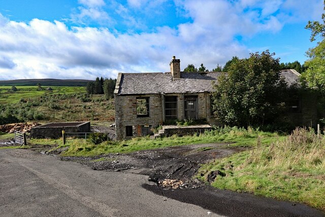
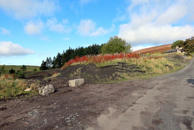
The shaft is capped and fenced, and still connects to the Blackett Level below. A roofless stone mine building stands beside it and the old Powder House survives in a field south of the site; the rest of the surface was cleared in the demolition of 1950, and the ground is grazed. Sipton Terrace, the workers' housing, and the Wesleyan chapel of 1862 at nearby Tedham had gone before the First World War.
A roofless stone mine building beside the capped shaft, and the old Powder House standing in a field south of the mine site; both are among the few structures left after the 1950 demolition.
Related mines
- Blackett Level — The Blackett Level was driven to drain the shafts at Sipton among others, and the mine is named on the level's own account.
- Holmslinn Mine — Both sat on the same drainage system and were owned by the same families, Blackett and Beaumont.
- St Peter's Mine — Both are East Allendale lead mines on the ground drained by the Blackett Level; St Peter's is named on the Sipton record.
Nearby mines
- St Peter's Mine — 1.3 miles (2.0 km) SW
- Holmslinn Mine — 1.6 miles (2.5 km) N
- Swinhope Mine — 2.5 miles (4.1 km) SW
- Allenheads Mines — 2.9 miles (4.7 km) S
- Scraithole Mine — 3.2 miles (5.2 km) SW
Straight-line distance, within 9 miles (15 km). Show on the map.
Recorded claims
Individual factual claims, each attached to the source(s) that support it below. Where sources disagree, both are kept.
- The Sipton Vein was discovered during the driving of the Blackett Level -- a drainage tunnel driven from Allendale Town toward Allenheads -- and worked for galena during the early-to-mid 1860s; the same shaft also gave access to Esp's Vein a kilometre to the north. 1
- Recorded company ownership runs from the W. B. Lead Co. Ltd (1902-21) to the Weardale Lead Co. Ltd (1923-48); the shaft remained in use until 1946, equipped with the last hydraulic hoist engine still operating anywhere in the North Pennine orefield. 2
- Sipton Mine supported its own workers' housing, Sipton Terrace, and a Wesleyan chapel built in 1862 at nearby Tedham, demolished before the First World War; the mine's own buildings were demolished in 1950. 1
- After the lead working ended the mine was reopened and worked for fluorspar, and was still in operation in 1985 - nearly forty years after the shaft's lead-era closure. 3,4,5
- Sixty-five people were employed at the mine in 1921: forty-one below ground and twenty-four on the surface. 3
- Most of the mine buildings were demolished in 1950. A few survive, among them the old Powder House, which stands in a field south of the mine site. 3
- Sipton was the second of the shafts sunk along the course of the Blackett Level, and the shaft, now covered, still connects to the level below. 4,5
- A photograph of the mine at work survives and has been dated from the dimensions of its plate to the 1860s or 1870s, with further views of the site in 1946 and 1965. 3,4
- The Mining Remediation Authority catalogue holds a plan of the Sipton and Holmes Linn shafts together, the two being the first pair sunk along the Blackett Level. 6
- The Blackett Level was begun in 1854 and driven up the East Allen to unwater the Allendale mines, reaching about four and a half of an intended seven and a half miles before work stopped in 1903. Four shafts were sunk along its course from about 1855, at Studdon Dene, Holmes Linn, Sipton and Breckon Hill, and the level still runs. 7
Photographs & further reading
Newcastle University's community heritage page for the mine, with the 1921 employment figures, the 1950 demolition and a gallery of Allen Valleys photographs of the site from the 1860s to 1965.
View sourceThe society's earliest photograph of the mine at work, dated from its plate, with a summary of the shaft's history through to the end of fluorspar working in 1985.
View sourceSources
- (secondary) Location Sipton (Allen Valleys Local History) — Allen Valleys Local History
- (secondary) Sipton - Level & Shaft (Buddlepit Mine Database) — Buddlepit Mine Database
- (secondary) Sipton Mine — Co-Curate, Newcastle University — Co-Curate, Newcastle University
- (secondary) Sipton, circa 1865 (Allen Valleys Local History) — Allen Valleys Local History
- (observational) Disused mine building and mine shaft at Sipton (Geograph 6630792) — Geograph Britain and Ireland
- (primary) BGS / Mining Remediation Authority mine plans: Sipton and Holmes Linn shafts — BGS / Mining Remediation Authority mine plans
- (observational) Blackett Level in Allendale — Fabulous North
Record created: 31 August 2026 · Last researched: 28 September 2026