 MineArchive
Blackett Level
| Also known as | Blackett Level, Allendale |
|---|---|
| Location | Allendale Town, Northumberland — 54.8987, -2.2552 (exact) |
| Commodity | Lead |
| Type | Metal |
| Worked | 1855–1903 |
| Maximum depth | Not applicable: a horizontal level, 4.68 miles driven of a planned 7.5. |
| Operators | W. B. Lead Company (1855–1903) |
Overview
A drainage and exploration tunnel driven into the East Allen valley from Allendale Town, begun in 1855 for the first Baron Allendale and engineered by Thomas Sopwith. It was meant to run seven and a half miles and stopped after 4.68, having found few profitable veins. It still runs, and still drains.
History
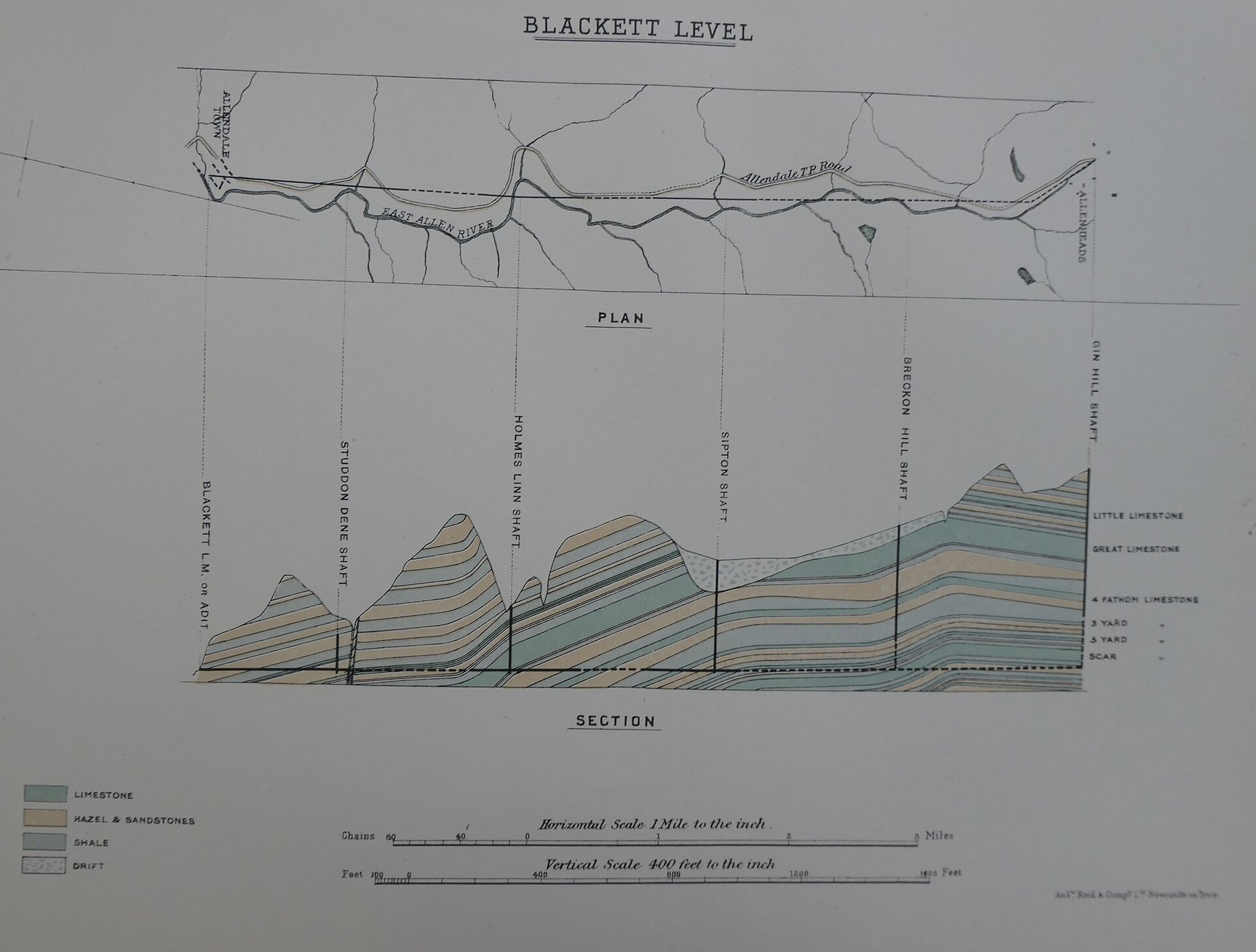
The Blackett Level was a substantial mine exploration and drainage system driven to open unknown ground in Allendale. It was engineered by Thomas Sopwith and Thomas John Bewick for the mine owner Wentworth Blackett Beaumont MP, first Baron Allendale, and work began in 1855.
The plan was ambitious: seven and a half miles of tunnel, both to lower the water in the mines above and to cut whatever lead veins lay in between. Lowering the water table is what kept the local mines working, and the level served the shafts at Studdon Dene, Holms Linn, Sipton and Breckon Hill; the ore went to be smelted at Allen Mill nearby. But few profitable deposits were found. Driving continued until 1903, when the price of lead had made it pointless, and the work was abandoned after 4.68 miles with the system incomplete.
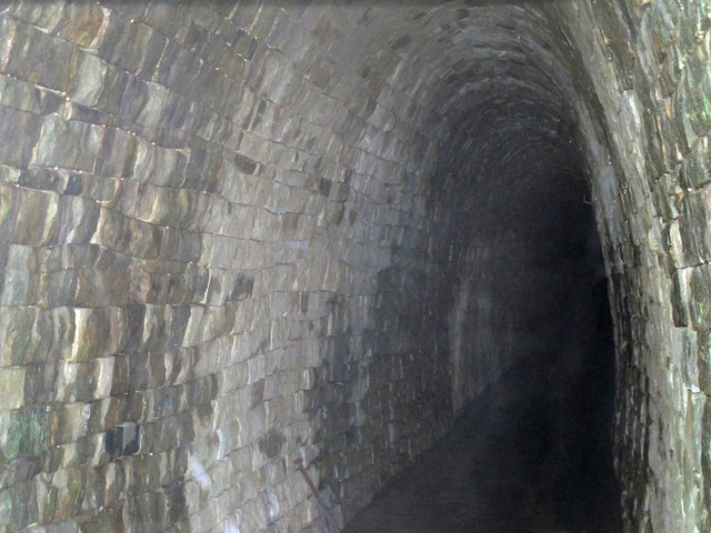
The tunnel is still there and still working. It carries an underground canal eight feet high and five feet wide, running from Allendale Town towards Allenheads, and the water still comes out at the portal by the river. From 1905 the ground around the portal was laid out as a pleasure garden, with bridges and vistas for visitors.
Geology
The level was driven through the Carboniferous rocks of the East Allen valley in the North Pennine orefield, cutting for the lead veins that run across the ground between Allendale Town and Allenheads. That it found few payable veins over nearly five miles is itself a finding about the ground: the productive ore shoots of this orefield are confined, and a straight line driven through it can miss them.
Geological setting: Veins and Lodes (well documented example)
Workings
A single tunnel driven from a portal at Allendale Town towards Allenheads, carrying an underground canal eight feet high and five feet wide. It was intended to reach seven and a half miles and reached 4.68. It drained the shafts sunk at Studdon Dene, Holms Linn, Sipton and Breckon Hill from about 1855.
Closure
Driving continued until 1903 and was then abandoned, the price of lead having made further work uneconomic and few profitable veins having been found. The level itself was never closed: it still drains.
What remains
The portal survives by the River East Allen at Allendale Town, built of coursed stone blocks with a narrow horseshoe arch of dressed voussoirs set in squared rubble, an iron girder bolted to the right jamb from the fittings of the original gate, and a twentieth-century iron grille across the mouth. The rustic building beside it was the Tally House, where the men clocked on and off and collected their pay. There is an information plaque, old rail tracks lie in the river, and the level is still discharging.
The stone portal and its arch, the ruined Tally House beside it, an information plaque, and rail track in the bed of the river.
Redevelopment
From 1905 the area around the portal was made into a pleasure garden with bridges and arranged vistas for visitors; people swam in the river below.
Related mines
- Allenheads Mines — The Blackett Level was driven to unwater the deep workings at Allenheads, which is how its listing describes its purpose; it never reached them.
- Holmslinn Mine — The Blackett Level was driven to drain the shafts at Holms Linn among others, and the mine is named on the level's own account.
- Sipton Mine — The Blackett Level was driven to drain the shafts at Sipton among others, and the mine is named on the level's own account.
Nearby mines
- Holmslinn Mine — 2.3 miles (3.7 km) S
- Stublick Colliery — 2.8 miles (4.4 km) N
- Langley Barony Mine — 3.4 miles (5.5 km) N
- Sipton Mine — 3.9 miles (6.2 km) S
- Morallee Fell Mine — 3.9 miles (6.3 km) N
Straight-line distance, within 9 miles (15 km). Show on the map.
What's uncertain
Points where sources disagree or the record could not be settled; both accounts are kept. All open questions in the archive.
- The list entry dates the portal to 1854; the Blackett family history says construction began in 1855. (disputed) 3
Recorded claims
Individual factual claims, each attached to the source(s) that support it below. Where sources disagree, both are kept.
- The Blackett Level was engineered by Thomas Sopwith and Thomas John Bewick for the mine owner Wentworth Blackett Beaumont MP, first Baron Allendale; construction began in 1855. 1
- The level was intended to reach seven and a half miles and to find new veins of lead ore, but few profitable deposits were discovered; driving continued until 1903 and was then abandoned after 4.68 miles with the system incomplete. 1
- The tunnel still exists and houses an underground canal eight feet high and five feet wide, running from Allendale Town towards Allenheads; the portal can be seen by the riverside at Allendale and is still discharging. 1,2
- The level drained the water from four lead mine shafts sunk at Studdon Dene, Holms Linn, Sipton and Breckon Hill from about 1855, and the ore was smelted at Allen Mill nearby. 2
- The portal is built of coursed stone blocks, its entrance a narrow horseshoe arch with dressed stone voussoirs set in a squared rubble wall, with an iron girder bolted to the right jamb from the fittings of the original iron gate and a twentieth-century iron grille across the mouth; the rustic building beside it was the Tally House where the men clocked on and collected their pay. 2
- The portal is listed at Grade II as 'Blackett Level, 100 metres north-west of parish church', list entry 1154086, listed on 23 August 1985 and described as an adit portal to a lead mine of 1854: a narrow horseshoe arch with dressed stone voussoirs set in a squared rubble wall, an iron girder bolted to the right jamb from the fittings of the old iron gate, a late twentieth-century iron grille just inside the mouth, and a stream emerging. 3
- The list entry calls it one of the best known levels in Allendale, worked until 1903, driven to unwater the deep workings at Allenheads and never completed. 3
- The list entry dates the portal to 1854; the Blackett family history says construction began in 1855. (disputed) 3
Photographs & further reading
The family history's account of the level — Sopwith and Bewick as engineers, the 1855 start, the intended seven and a half miles, the 4.68 actually driven and the abandonment in 1903.
View sourceThe Grade II listing of 23 August 1985, which describes the portal and its ironwork and records what the level was driven for.
View sourceSources
- (secondary) An engineering achievement: the Blackett Level — The Blacketts of North East England
- (observational) Blackett Level in Allendale — Fabulous North
- (primary) Blackett Level, 100 metres north-west of Parish Church, list entry 1154086 — Historic England
Record created: 9 September 2026 · Last researched: 9 September 2026