 MineArchive
Penberthy Croft Mine
| Also known as | Penberthy Crofts |
|---|---|
| Location | St Hilary, near Goldsithney, Cornwall — 50.1413, -5.4238 (exact) |
| Commodities | Arsenic, Copper, Lead, Tin |
| Type | Metal |
| Worked | 1798–late 1840s |
| Maximum depth | 53 fathoms (about 97 m) below adit |
Overview
A copper and tin mine in the parish of St Hilary, about a mile north-east of Goldsithney, worked in the late eighteenth and nineteenth centuries and never large. Its importance today is entirely mineralogical: the dumps spread over open ground at the site are the richest source in Britain of secondary lead, copper and arsenic minerals, with some ninety-six confirmed species, and the mine is the type locality for bayldonite and for two minerals named after it. It was notified as a Site of Special Scientific Interest in 1993 and is listed in the Geological Conservation Review.
History
Penberthy Croft is believed to be an old working, but the record of it is thin. Production is usually dated from 1798, and the mine is credited with about 3,000 tons of copper ore in its first phase. Dines gives recorded outputs only for 1818, 1824 and the years 1881 to 1883: 8,700 tons of copper ore at 7 per cent, 60 tons of black tin and a ton and a quarter of lead ore at 60 per cent. Copper gave way to mixed copper and tin working at greater depth. The mine was producing very little by 1840 and is thought to have closed in the late 1840s, with a further short phase of working in the early 1880s; mine databases accordingly give its span as 1798 to 1883. The detailed history was written up by Hamilton Jenkin in 1965, and Dines set out the mining sett in 1956.
Its later reputation was made by collectors rather than by ore. It was noted for pyromorphite and mimetite by the middle of the nineteenth century. Bayldonite, a copper-lead arsenate, was originally described as coming from the St Day area, but Kingsbury and others have argued the original material came from here, and Penberthy Croft is now taken as its type locality. It is also the type locality for bettertonite and penberthycroftite, the first recorded British site for segnitite, and joint first for jeanbandyite and natanite. When tin prices were high the dumps were sampled again to see what tin they still held.
Geology
The mine lies in Devonian metasediments, chiefly lower-greenschist-facies slates of the Mylor Slates Formation, cut by east-west metabasic rocks. The Main Lode courses east to west, running parallel to a quartz-feldspar porphyry or elvan dyke about 140 m to the south. Tin, copper and lead minerals all occur in the dump material, so the Main Lode is either a double lode or the mineralisation is telescoped; the lead may instead be carried by small cross-courses. Two further lodes leave the Main Lode: Longdose Lode from the footwall, and Canant Lode from the hangingwall.
Geological setting: Hydrothermal Deposits (well documented example), Veins and Lodes (well documented example)
Workings
Copper and tin were worked to a maximum of 53 fathoms below adit, with small amounts of lead raised as well. The Main Lode was followed about 280 m east and 830 m west of the lane at Long Lanes, and the total worked distance along the lode system is around 3 km. Five areas of the dumps are recognised as the richest for mineral species, each named for the shaft whose waste built it: Dukes Shaft with 52 confirmed species, Daws Shaft with 51, Ducketts Shaft with 48, and the pharmacosiderite and birnessite dumps with 41 and 39.
Closure
Little was coming out by 1840 and the mine is thought to have stopped in the late 1840s, with a brief further phase of production in 1881-83.
What remains
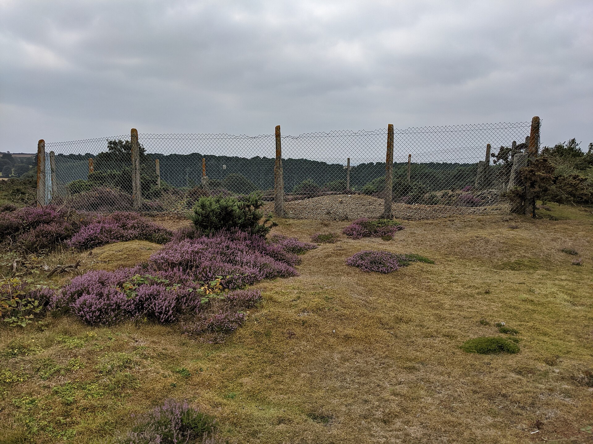
Extensive dumps cover a large area of open ground, and remain the reason anyone comes here. Shafts are fenced and warning signs are posted. A 2021 observation records the site in use as a bike park, with tracks through the workings and the ground still bare enough of vegetation to suggest it stays toxic. The land belongs to the St Aubyn Estate and access for collecting or research needs permission from the estate's agent.
Extensive dumps over a large area of open ground, with fenced shafts.
Nearby mines
- Halamanning Mine — 1.1 miles (1.7 km) SE
- Tregurtha Downs Mine — 1.3 miles (2.2 km) SW
- West Godolphin Mine — 1.9 miles (3.1 km) E
- Great Work Mine — 2.7 miles (4.4 km) E
- Godolphin Mine — 3.2 miles (5.1 km) E
Straight-line distance, within 9 miles (15 km). Show on the map.
What's uncertain
Points where sources disagree or the record could not be settled; both accounts are kept. All open questions in the archive.
- Sources put the working life differently. The Geological Conservation Review has the mine producing very little by 1840 and believed closed in the late 1840s, but records output again in 1881-83; mine databases give the span as 1798 to 1883, and a 2021 field note says simply that it closed in 1840. (disputed) 1,2,3
Recorded claims
Individual factual claims, each attached to the source(s) that support it below. Where sources disagree, both are kept.
- Copper and tin were worked to a maximum of 53 fathoms below adit. 1,2
- Dines records 8,700 tons of copper ore at 7 per cent, 60 tons of black tin and 1.25 tons of lead ore at 60 per cent, for the years 1818, 1824 and 1881 to 1883 only; historical records of output are otherwise sparse. 1
- Sources put the working life differently. The Geological Conservation Review has the mine producing very little by 1840 and believed closed in the late 1840s, but records output again in 1881-83; mine databases give the span as 1798 to 1883, and a 2021 field note says simply that it closed in 1840. (disputed) 1,2,3
- Some 96 mineral species have been confirmed at Penberthy Croft. It is the type locality for bayldonite, bettertonite and penberthycroftite, the first recorded British site for segnitite, and joint first for jeanbandyite and natanite. 1,4
- The site was notified as a Site of Special Scientific Interest in 1993 and is listed as of national importance in the Geological Conservation Review. 1,4
Photographs & further reading
The JNCC's account of the site, with the lode structure, the recorded outputs and the full authenticated list of 96 mineral species.
View sourceSources
- (primary) Penberthy Croft Mine, Cornwall — Mineralization of England and Wales, Geological Conservation Review Series No. 36 — Joint Nature Conservation Committee
- (observational) Penberthy Crofts — Buddlepit Mine Database
- (observational) Penberthy Croft mine is now a bike park — Geograph Britain and Ireland
- (secondary) Penberthy Croft Mine — Wikipedia
Record created: 9 September 2026 · Last researched: 9 September 2026