 MineArchive
Gurney Slade Quarry
| Also known as | Gurney Slade Bottom Quarry |
|---|---|
| Location | Gurney Slade, between Binegar and Holcombe, Somerset — 51.2452, -2.5372 (exact) |
| Commodity | Limestone |
| Type | Stone |
| Worked | Mid 19th century–Still active |
| Maximum depth | Not applicable: surface quarrying. |
| Operators | F. Flower and Sons (1928–1930), Morris and Perry Ltd (1962–?) |
Overview
The largest of the East Mendip limestone quarries and still working, begun on a small scale in the mid nineteenth century and expanded after 1928 to feed Francis Flower's limekilns. Its faces show an angular unconformity where Triassic and Jurassic rocks rest on the tilted Carboniferous limestone, and fissures in the old sea floor are filled with Jurassic sediment.
History
Quarrying began at Gurney Slade on a small scale in the middle of the nineteenth century; by some accounts Francis Flower started burning lime here in 1873. The operation was expanded considerably after 1928 by F. Flower and Sons to feed limekilns, some of which still stand. In the 1930s one of Flower's main customers, the Poole building merchant Blanchard and Burgess, took control. The quarry closed in 1947 and reopened in 1951, worked for a short period by John Yeoman, and passed to the City Sand and Gravel Company; in 1962 another customer, Sidney Morris from near Yeovil, and his son-in-law George Perry took over and formed Morris and Perry Ltd, which still operates it.
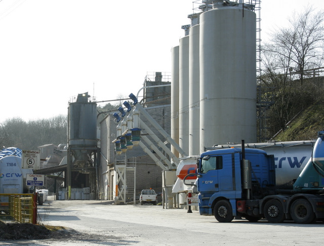
A concrete plant was installed in 1963 and a coated macadam plant in 2001, and the site can supply up to two million tonnes of limestone aggregate a year. Francis Flower meanwhile turned to mineral powders and powder haulage, and the company is still based at Gurney Slade with a plant beside the quarry, processing limestone dust collected from quarries across England and Wales — filter-bag emissions from drilling and processing — and classifying it by size to sell back to asphalt makers.
Geology
The quarry sits at the eastern end of the Pen Hill Pericline, one of the four major up-folds of the Mendips, where the Carboniferous limestone plunges eastward beneath the Quartzitic Sandstone and the Coal Measures. Its faces expose pale to very dark grey Carboniferous limestone, dipping south-east at about thirty degrees, overlain by red and purple Triassic breccias and marls with a small faulted block of Lower Jurassic breccia above — an angular unconformity, the younger beds lying across the cut-off edges of the older. Fissures and joints in the old limestone surface are filled from above with later sediment, the neptunian dykes that are the site's other distinction, and the rock carries calcite mineralisation and fossils from both the Carboniferous and the Jurassic.
Geological setting: Faults and Fractures (well documented example), Sedimentary Beds and Seams (well documented example)
Workings
A large open aggregate quarry with its own concrete plant, installed in 1963, and a coated macadam plant from 2001, capable of supplying up to two million tonnes a year. Some of the limekilns built up after 1928 survive on the site.
Closure
Not closed. The quarry shut in 1947 and reopened in 1951, and has worked continuously since under a succession of owners, currently Morris and Perry Ltd.
What remains
A working quarry with associated plant, and a Francis Flower facility alongside it processing limestone filler from quarries across England and Wales. The geological features of the faces were recorded in a geodiversity audit of active aggregate quarries in the region in 2004.
Not applicable: the quarry is in production. Some of the old limekilns survive.
Redevelopment
None; the site is still extractive.
Nearby mines
- New Rock Colliery — 1.6 miles (2.5 km) E
- Fairy Cave Quarry — 2.4 miles (3.8 km) SE
- Wellsways Colliery — 2.5 miles (4.0 km) NE
- Norton Hill Colliery — 3.4 miles (5.5 km) NE
- Old Mills Colliery — 3.6 miles (5.8 km) NE
Straight-line distance, within 9 miles (15 km). Show on the map.
What's uncertain
Points where sources disagree or the record could not be settled; both accounts are kept. All open questions in the archive.
- Wikipedia says work began at the quarry in the mid eighteenth century; the British Geological Survey's history of the East Mendip quarries says it began on a small scale in the mid nineteenth century, with some accounts giving Francis Flower's lime-burning here as starting in 1873. (disputed) 3,1
Recorded claims
Individual factual claims, each attached to the source(s) that support it below. Where sources disagree, both are kept.
- The quarry exposes pale to very dark grey Carboniferous limestone overlain by red and purple Triassic breccias and marls, with a small faulted block of Lower Jurassic breccia forming an angular unconformity with the Carboniferous limestone; there is abundant vertical sediment infilling fissures and joints, and the limestone dips south-east at about thirty degrees. 1
- Gurney Slade lies at the eastern end of the Pen Hill Pericline, one of the four major up-folds on the Mendips, where the Carboniferous limestone plunges eastward beneath the Upper Carboniferous Quartzitic Sandstone and the Coal Measures. 2
- The quarry was expanded after 1928 by F Flower and Sons to feed limekilns; Blanchard and Burgess of Poole took control in the 1930s; it closed in 1947, reopened in 1951 under John Yeoman, passed to City Sand and Gravel, and in 1962 Sidney Morris and his son-in-law George Perry took over, forming Morris and Perry Ltd. 3,1
- Wikipedia says work began at the quarry in the mid eighteenth century; the British Geological Survey's history of the East Mendip quarries says it began on a small scale in the mid nineteenth century, with some accounts giving Francis Flower's lime-burning here as starting in 1873. (disputed) 3,1
- The site is capable of supplying up to two million tonnes a year of Carboniferous limestone aggregate; a concrete plant was installed in 1963 and a coated macadam plant in 2001. 1
Photographs & further reading
The Survey's account of quarrying across the East Mendips, with the ownership sequence at Gurney Slade from Francis Flower's limekilns to Morris and Perry.
View sourceSources
- (secondary) Gurney Slade quarry — Wikipedia
- (primary) Gurney Slade and Emborough, from Foundations of the Mendips — British Geological Survey
- (primary) History of the East Mendip quarries (Foundations of the Mendips) — British Geological Survey
Record created: 9 September 2026 · Last researched: 9 September 2026