 MineArchive
Old Mills Colliery
| Also known as | Old Mills and Springfield Collieries, Springfield Colliery |
|---|---|
| Location | Paulton and Midsomer Norton, Somerset — 51.2926, -2.5040 (approximate) |
| Commodity | Coal |
| Type | Coal |
| Worked | 1860–1966 |
| Maximum depth | 1,098 ft (335 m) at Old Mills; 965 ft (294 m) at Springfield |
| Operators | William Evans and Company (?–1947), National Coal Board (1947–1966) |
Overview
Sunk in 1860 north of the main road at Paulton, with Springfield opened south of it in 1872; the two were linked on the surface by a narrow-gauge tramway from the start and underground in October 1941, after which the combined collieries were known as Old Mills. The Old Mills shaft was 11 feet across and 1,098 feet deep, Springfield’s 9 feet 6 inches and 965 feet. William Evans and Company held them — the 1880 list of collieries at work returns "Old Mills, Paulton, William Evans and Co." — until nationalisation. Once Old Mills stopped winding coal its shaft was used for supplies and for training men for the Somerset pits, and the north site carried the Coal Board’s workshops and classrooms for apprentice electricians and engineers. The colliery closed in 1966, leaving only Kilmersdon and Writhlington.
History
Old Mills was opened in 1860 on the north side of the main road between Paulton and Midsomer Norton, and Springfield in 1872 a short distance south of it. The two were worked together from early on, linked at the surface by a narrow-gauge tramway, and were owned by William Evans and Company, whose name the official list of collieries at work returns against Old Mills in 1880 and which Grace’s Guide still records in the list of colliery undertakings for 1922. An underground connection between the two was made in October 1941, and from then on they were operated and known as one colliery, Old Mills.
The Old Mills shaft was afterwards closed for coal winding and kept for supplies and for training men for their employment in the Somerset mines — a role the Somerset field needed as its pits contracted and men transferred between them. At the north site were the workshops and classrooms used by the National Coal Board for apprentice electricians and engineers, which served until Radstock Technical College opened. The colliery baths stood opposite Springfield pit on the south side; a warehouse operates on the site now.
Old Mills closed in 1966. Most of its miners were transferred to Kilmersdon and Writhlington, which were by then the only pits left in the Somerset coalfield; both closed in 1973.
Geology
The Somerset coalfield around Paulton and Midsomer Norton, where the Coal Measures were tightly folded, fractured and faulted by the Variscan movements and the seams are thin though the coal is of good grade. The two Old Mills shafts went 1,098 and 965 feet for it. The colliery’s spoil tip — the batch, in the Somerset word — is a conspicuous conical hill above Midsomer Norton and one of the most visible relics of the field.
Geological setting: Faults and Fractures (well documented example), Sedimentary Beds and Seams (well documented example)
Workings
Two shafts a few hundred yards apart across the main road: Old Mills, 11 feet in diameter and 1,098 feet deep, and Springfield, 9 feet 6 inches and 965 feet. They were linked at the surface by a narrow-gauge tramway and, from October 1941, underground as well, after which winding was concentrated at Springfield and the Old Mills shaft carried supplies and training parties instead of coal. The pithead baths were on the south side, opposite Springfield.
Closure
Old Mills closed in 1966 and most of its men were transferred to Kilmersdon and Writhlington, the last two pits in the Somerset coalfield, which closed together in 1973. The Somerset field had gone from thirty pits at the start of the century to twelve at nationalisation and five by 1959; Old Mills was among the last to go.
What remains
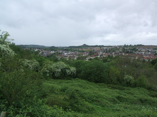
The colliery is gone and its two sites reused. Old Mills Batch, the spoil tip, is a conspicuous conical hill with a largely unvegetated surface above Midsomer Norton and was photographed in May 2007; the disused colliery sites in this group have been developed for light industry, a depot and a superstore, and a warehouse now stands where the pithead baths were.
Old Mills Batch, the distinctive conical spoil tip above Midsomer Norton, and Old Mills Lane, which carries the name. The colliery buildings have gone.
Redevelopment
Light industry, a depot and a superstore on the former colliery sites.
Nearby mines
- Writhlington Colliery — 0.3 miles (0.6 km) NE
- Norton Hill Colliery — 1.3 miles (2.1 km) SE
- Wellsways Colliery — 1.8 miles (2.9 km) S
- Clandown Colliery — 2.2 miles (3.5 km) NE
- Greyfield Colliery — 2.4 miles (3.9 km) N
Straight-line distance, within 9 miles (15 km). Show on the map.
Recorded claims
Individual factual claims, each attached to the source(s) that support it below. Where sources disagree, both are kept.
- The official list of collieries at work in 1880 returns the pit as "Old Mills, Paulton, William Evans and Co." 1
- Old Mills opened in 1860 north of the main road and Springfield in 1872 to the south; the Old Mills shaft was 11 ft in diameter and 1,098 ft (366 yards) deep and Springfield’s 9 ft 6 in and 965 ft (321 yards). Both closed in 1966. 2,3
- The two collieries were originally linked on the surface by a narrow-gauge tramway; an underground connection was made in October 1941, after which the combined collieries were known as Old Mills. 3
- After the Old Mills shaft was closed for coal winding it was used for supplies and for training men for their employment in the Somerset mines, and the north site carried the workshops and classrooms for National Coal Board apprentice electricians and engineers until Radstock Technical College opened. 3
- The collieries were owned by William Evans and Company, returned against Old Mills in the 1880 list of collieries at work and against Springfield in the mine inspectors’ list of 1908, and still recorded in the 1922 list of colliery undertakings. 1,4,2
- Old Mills closed in 1966 and most of its miners were transferred to Kilmersdon and Writhlington, by then the only two pits left in the Somerset coalfield. 3
- Old Mills Batch, the colliery’s spoil tip, is a highly visible and distinctly conical hill with a generally unvegetated surface above Midsomer Norton; the three disused colliery sites in this group have been developed for light industry, a depot and a superstore. 2
Photographs & further reading
The local account of the two pits, with an audio track: the 1941 underground connection that made them one colliery, the shaft depths, the training role the Old Mills shaft took on afterwards, and the Coal Board classrooms on the north site.
View sourceSources
- (secondary) List of coal mines UK 1880 — Coalmining History Resource Centre
- (secondary) Somerset Coalfield — Wikipedia
- (secondary) Old Mills — Somer Valley Audio Trails — Somer Valley Audio Trails
- (primary) 1922 Colliery Undertakings — Grace’s Guide to British Industrial History
- (observational) Old Mills Batch and Midsomer Norton (photographed 12 May 2007) — Nigel Shoosmith, Geograph Britain and Ireland
Record created: 6 September 2026 · Last researched: 6 September 2026